Powered by WUFT
Temporarily change filter
Finding your station


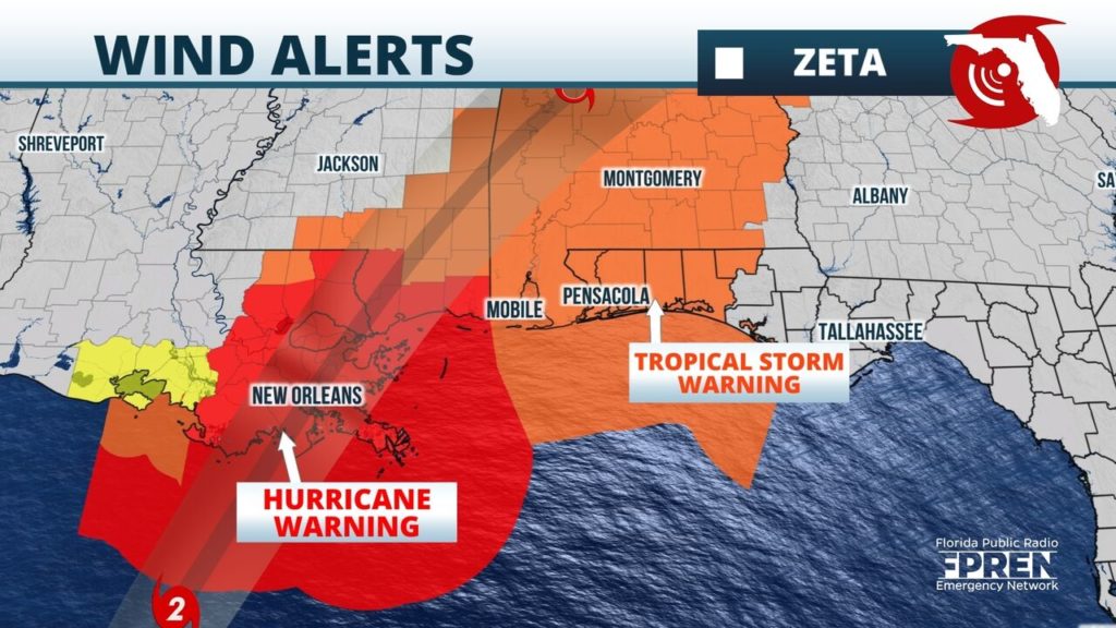
Zeta regained hurricane strength early Wednesday morning over the warm waters of the central Gulf of Mexico. It is forecast to strengthen more and may attain category 2 status prior to landfall along the Louisiana Gulf coast late Wednesday afternoon.
Tropical storm force winds are expected to arrive along the Gulf coast from Louisiana to the western Florida Panhandle between mid-afternoon and sunset Wednesday, before subsiding in the hours prior to dawn on Thursday. Hurricane force winds are most likely in the hurricane warning area over Louisiana and Mississippi early Wednesday evening.
During this time, frequent tropical storm force wind gusts and occasional tropical storm force sustained winds are likely from Pensacola to Destin and Fort Walton Beach. A cold front following Zeta may bring a separate round of scattered thunderstorms over the Florida Big Bend region, including Tallahassee, Perry, and Lake City during the daylight hours of Thursday. Strong winds throughout the atmosphere and daytime heating may result in a couple of strong storms with a brief, isolated tornado threat. The scattered showers and storms are expected to weaken shortly after sunset Thursday as they approach Northeast and North-Central Florida, including Jacksonville and Gainesville.
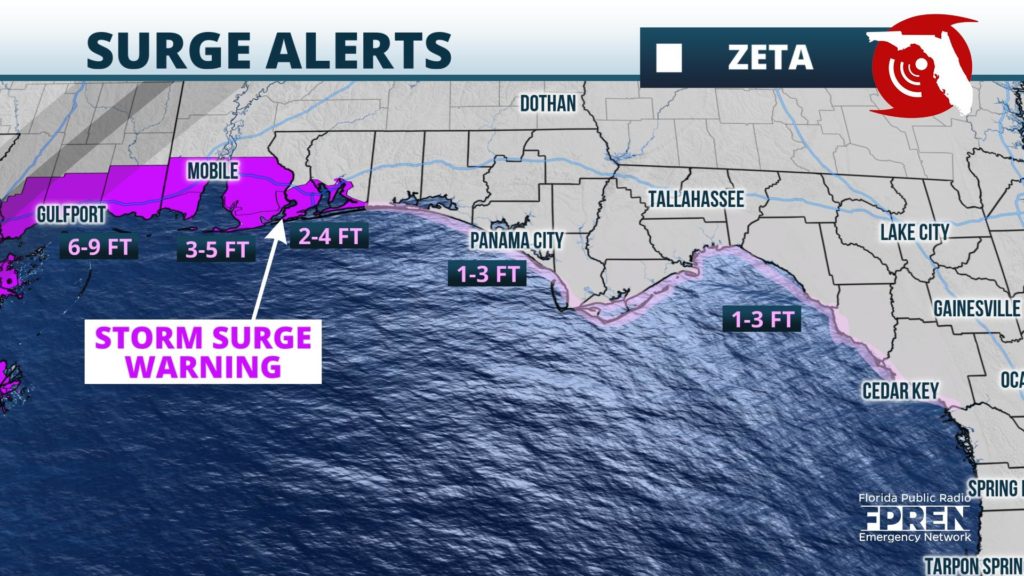
Strong onshore winds are expected to pile water on to the coast. Storm Surge Warnings continued from the Atchafalaya River, Louisiana to Navarre, Florida. 6 to 9 feet of water above normally dry ground is possible along the Mississippi and Alabama coastlines, which are particularly storm surge zone. Water levels as high as 2 to 4 feet are possible into the western Florida Panhandle, especially near the time of high tide within a few hours of midnight. Minor water level rises are anticipated as far east as the Forgotten coast, where Coastal Flood Advisories have been posted.
The storm’s fast forward motion is expected to spread tropical storm force wind gusts well inland over Mississippi, Alabama, and Georgia early Thursday morning. These winds are capable of producing power disruptions to areas far away from the coast. Pockets of flash flooding are possible, but the quick movement of the storm should limit total rainfall amounts to around 1 inch in the western Florida Panhandle to as high as 2 to 4 inches in a swath from southeast Louisiana to Mississippi, Alabama, north Georgia, and the Upstate of South Carolina.
