Powered by WUFT
Temporarily change filter
Finding your station


Yet another storm system is developing out west, and it's arrival Wednesday evening will bring another chance for dangerous thunderstorms.
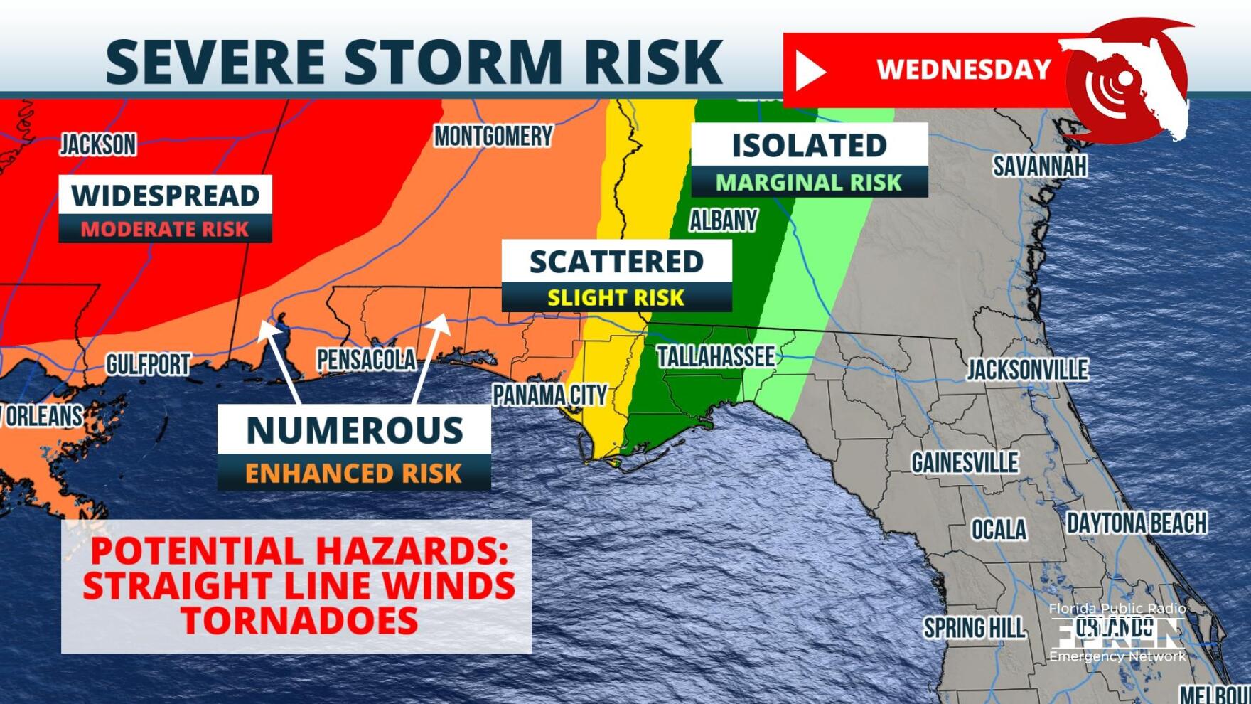
Meteorologists at the Storm Prediction Center say that the region from Panama City to Pensacola is under a Enhanced Risk, or level 3 out of 5, for thunderstorms capable of producing dangerous tornadoes and dangerous straight-line winds Wednesday night. The risk area shifts eastward toward the Forgotten Coast and Big Bend on Thursday. Those areas are under a Slight Risk for dangerous storms, or level 2 out of 5.
A squall line of thunderstorms is expected to develop along an eastward advancing cold front during the day Tuesday. The boundary was located over the western United States early Tuesday morning, but is forecasted quickly lift northeastward throughout the day. Dangerous storms could impact the Central and Southern Plains late Tuesday, before arriving to the Lower Mississippi Valley and Central Gulf Coast Wednesday. By Wednesday evening, an established squall line is expected to push into the western Panhandle, and slowly push from southwest to northeast through the area.
Ahead of the squall line, damaging wind gusts will be possible. Environmental dynamics could encourage some of the cells within the line to develop rotation. This could support tornado formation, and a few could be long tracking. As of the latest model information on Tuesday morning, parameters for those long tracking tornadoes will be strongest not in Florida, but rather over Southern Mississippi and Alabama. Even so, a stray strong tornado cannot be ruled out of the forecast for the western Panhandle.
The squall line should migrate eastward through the Panhandle Wednesday night, arriving near Tallahassee on Thursday morning. It'll then sink into North Florida during the afternoon and likely near the I-4 corridor in Central Florida Thursday night. In these areas, the most prominent hazard will be damaging wind gusts, but again tornadoes cannot be ruled out of the forecast.
In addition to straight-line winds and tornadoes, heavy rain rates are expected from the storms. Water levels are still high from excessive rainfall earlier this month, and local flooding will become likely, especially in low lying and poorly drained locations.
The boundary is expected to stall near Central Florida by Friday, before slowly sinking toward South Florida later in the weekend. As a result, cloud cover and showers should persist over the Florida peninsula on Friday and into the weekend.
9(MDA5NDY0MjA5MDEzMzcwMjQ4MTUxZWMwMg004))
1885 Stadium Road
PO Box 118405
Gainesville, FL 32611
(352) 392-5551
A service of WUFT at the University of Florida College of Journalism and Communications


Partners of the Florida Public Radio Emergency Network include: Florida's Division of Emergency Management, WDNA (Miami), WFIT (Melbourne), WMFE (Orlando), WFSU (Tallahassee), WGCU (Fort Myers), WJCT (Jacksonville), WKGC (Panama City), WLRN (Miami), WMNF (Tampa-Sarasota), WQCS (Fort Pierce), WUFT (Gainesville-Ocala), WUSF (Tampa), WUWF (Pensacola) and Florida Public Media.
This page uses the Google Privacy Policy and UF's Privacy Policy
