Powered by WUFT
Temporarily change filter
Finding your station


Latest forecast data suggests there is an increasing chance that Tropical Storm Dorian will affect parts of Florida this weekend. However, the location, timing and extent of those impacts can not be credibly projected at this time.
Tropical Storm Dorian was moving through the Windward Islands Tuesday morning, and as of the 5 am advisory from the National Hurricane Center, was producing winds up to 50 mph. A Hurricane Watch has been issued for Puerto Rico and the eastern third of the Dominican Republic. Official advisory information has been included in the section below.
Dorian is forecast to be near hurricane strength when it moves close to Puerto Rico and eastern Hispaniola Wednesday. Thereafter, forecasters have expressed “considerable uncertainty” on the track and strength of the season’s fourth tropical storm. Potential interactions with land, and the extent to which Dorian’s structure may be affected, are difficult to ascertain with any confidence at this point.
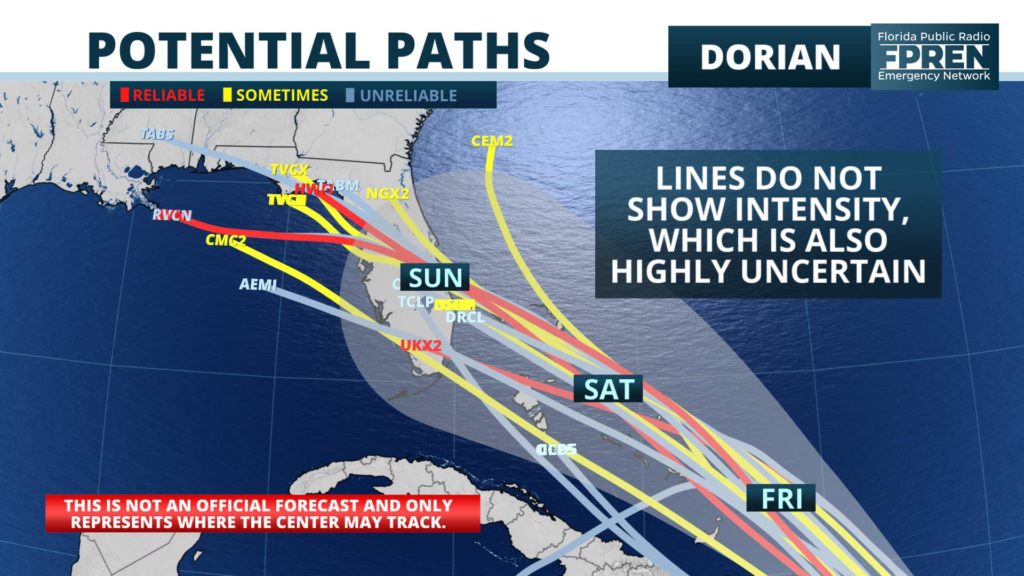
The average forecast track error of a forecast 48 hours into the future is around 60 nautical miles (either side of the line), based on data published by the National Hurricane Center since 1970. The produces a diameter of uncertainty larger than Puerto Rico is wide (west to east), which is about 110 miles. This “cone of uncertainty”, as it is often called, is nearly 400 miles wide at the time Dorian could make landfall in Florida, or roughly the distance from Miami to Jacksonville.
Meteorologist Ray Hawthorne has contributed to this section of the story.
How strong Dorian will be as it moves near or over Hispaniola and Puerto Rico will have significant future implications to Florida, if it affects the state. For the last few days, dry air surrounding the storm has prevented it from significantly strengthening. However, the winds high in the atmosphere above Dorian have been light, which is why it has been able to maintain its intensity. Several of the models forecast Dorian to come close to axis of stronger wind shear as it approaches the Dominican Republic and/or Puerto Rico. These stronger high-altitude winds may entrain even more dry air into Dorian, which would cause weakening.
Hispaniola and Puerto Rico are both mountainous islands. If Dorian moves directly over the rugged terrain, the storm’s spin would become disrupted. It’s also entirely possible the tropical storm will move over the Mona Passage (which is the strip of water between the two islands). Should that scenario occur, Dorian may not weaken quite as much as it otherwise would.
If Dorian survives the wind shear, dry air, and land interaction, the global models forecast a favorable environment for the storm to strengthen Friday into the upcoming holiday weekend. The water temperatures surrounding the Bahamas are in the mid 80s and light wind shear is anticipated. Odds are starting to tilt in favor of the storm holding on and restrengthening near the Bahamas, but this is not yet a guarantee.
The future path of Dorian is much clearer than its future strength. A large ridge of high pressure over the western Atlantic Ocean and Mid-Atlantic states would steer the storm in the general direction of the Florida east coast. A large majority of the most reliable models show this scenario unfolding. Once the storm passes Hispaniola on Thursday, we should have much greater confidence regarding the storm’s strength and potential effects to the Sunshine State.
Due to the expressed high levels of uncertainty in Tropical Storm Dorian’s forecast, all residents of Florida have been encouraged by the National Weather Service to monitor the progress of the storm, stay informed, and ensure their hurricane plan is in place.
1885 Stadium Road
PO Box 118405
Gainesville, FL 32611
(352) 392-5551
A service of WUFT at the University of Florida College of Journalism and Communications


Partners of the Florida Public Radio Emergency Network include: Florida's Division of Emergency Management, WDNA (Miami), WFIT (Melbourne), WMFE (Orlando), WFSU (Tallahassee), WGCU (Fort Myers), WJCT (Jacksonville), WKGC (Panama City), WLRN (Miami), WMNF (Tampa-Sarasota), WQCS (Fort Pierce), WUFT (Gainesville-Ocala), WUSF (Tampa), WUWF (Pensacola) and Florida Public Media.
This page uses the Google Privacy Policy and UF's Privacy Policy
