Repeating rounds of heavy rain could produce flooding across portions of the Florida Panhandle Monday.
A weak, but slow-moving area of low pressure formed near Tallahassee Sunday, and the moisture being drawn into it has already resulted in numerous rounds of heavy rain. A Flash Flood Warning was issued for Gulf County Sunday evening, where the National Weather Service estimates three to four inches of rain fell in under an hour.
Flash Flooding may occur again Monday in other areas of the Florida Panhandle, stretching from the Emerald Coast to Tallahassee. The Weather Prediction Center has highlighted these locations has having a “slight risk” of excessive rainfall, which is a level two out of four on their scale.
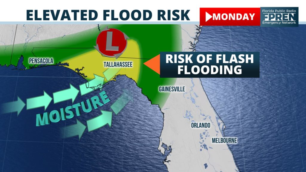
Forecast data does not suggest the heavy rainfall will be widespread, but rather indications are that some locations may receive as much as five inches of rain where the thunderstorm cells are most concentrated or persistent. The highest chances of this happening are in an area highlighted on the map above, roughly near and 50 miles either side of a line from Panama City to Tallahassee.
Pockets of heavy rain may also develop further south and east across Florida’s Big Bend or Nature Coast regions, but the duration and amounts are not likely to be as extreme. Residents in those locations likely don’t want or need any more rain.
More than a foot of water has fallen out of the sky in most of Dixie, Levy and Taylor counties over the weekend, where widespread flooding continues. Leading the list was a WeatherBug station near Steinhatchee, where 30.15 inches of rain has been recorded since Thursday. Several other locations along Florida’s Big Bend and Nature Coast have tallied rainfall totals in the 12 to 20-inch range during the same time period.
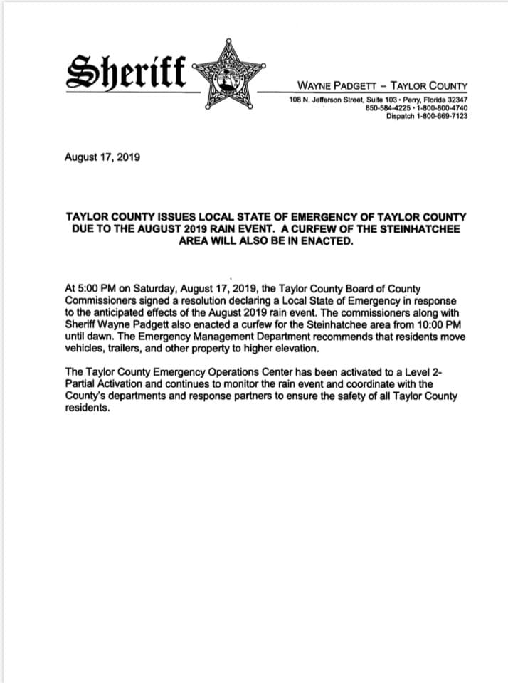
A State of Emergency was declared by Taylor County officials Saturday evening, and is in effect until further notice. Shelters have been opened for residents forced from their homes due to flooding along the Steinhatchee River, and all nearby residents were encouraged to “move vehicles, trailers and property to higher elevation.” During the emergency declaration, a curfew goes into effect at 10 pm every night until dawn.
As of Sunday evening, more than two dozen roads were also closed due to flooding in Levy and Dixie Counties. School districts in both counties have cancelled classes Monday, and most roads in the communities of Cedar Key, Inglis, Yankeetown and Suwannee have “some level of flooding” according to their respective offices of emergency management.
The flood risk may not be as widespread or severe across the Florida Panhandle Monday as it was over the weekend further south, although high rainfall rates may produce flash flooding. This is a more sudden rise in water near creeks, streams and low-lying areas that can sweep across roads and inundate homes with little notice. Flash flooding is the number one weather-related killer in the United States, claiming 1028 lives since 2010 according to data published by the National Weather Service.
Residents who live, work, or drive through areas prone to flooding are encouraged to stay informed of the latest weather situation, check in often for updates, and never attempt to drive through a flooded roadway. 58 percent of the flood-related fatalities mentioned above (since 2010) have occurred while driving.


