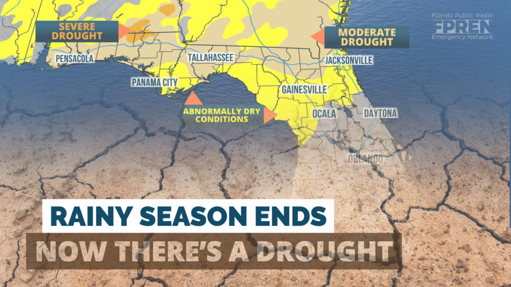
A moderate drought is now affecting much of the Florida Panhandle, and some cities haven’t received a drop of rain in more than four weeks. This comes as Florida’s rainy season ends early and the driest months of the year are still to come.
Rainfall has been below average for the entire state this month, and in some spots, non-existent. As of Thursday, Pensacola and Tallahassee had not received any measurable rain in September. Average rainfall for the month in Pensacola is 5.98 inches, with Tallahassee receiving 4.69 inches on average. A similar situation has developed on the other side of the state in Miami, where there is a September rainfall deficit of 6.62 inches.
Monthly rainfall accumulations as of Sep. 26, compared to normal September values, are provided below.
| CITY | RAIN SO FAR | SEPT. NORMAL |
| Pensacola | 0.00" | 5.98" |
| Tallahassee | 0.00" | 4.69" |
| Gainesville | 0.93" | 4.42" |
| Tampa | 1.45" | 6.30" |
| Orlando | 1.84" | 6.06" |
| Melbourne | 2.09" | 7.64" |
| Jacksonville | 2.35" | 8.19" |
| Fort Myers | 2.86" | 8.31" |
| Miami | 3.24" | 9.86" |
| Fort Pierce | 3.42" | 6.03" |
The departures from normal may look extreme, but it must be noted that average rainfall numbers in September are often skewed by tropical storms or hurricanes.
The National Drought Mitigation Center (NDMC) at the University of Nebraska publishes a weekly Drought Monitor Index to assess how severe the conditions are. In their update Thursday, all of north Florida was considered to be at least “abnormally dry”, and 21% of the state - nearly all areas along and north of I-10 - was classification as being in a “moderate drought”. The NDMC identifies the situation as a “flash drought”, which is used to describe a period of abnormally high temperatures and increased evaporation rates that exacerbated the drought.
Climatology alone would suggest drier days are in Florida’s future, as the rainy season typically ends over the next couple of weeks. However, it seems to have concluded early this year thanks to a quasi-persistent wind pattern that promotes warm temperatures and little rain.
State Climatologist David Zierden says this pattern can be traced back to the beginning of September, when Hurricane Dorian decided to turn north and miss Florida.
“When you get a big, strong, big storm that is that strong, it can kind of pull in dry or air from the north and enhance the ridging,” he says. Zierden is referring to an area of high pressure that causes sinking air and suppresses precipitation. “And then we had Humberto, that didn't come as close, but it still had much the same effect on pulling in a dry and warmer air mass,” he adds.
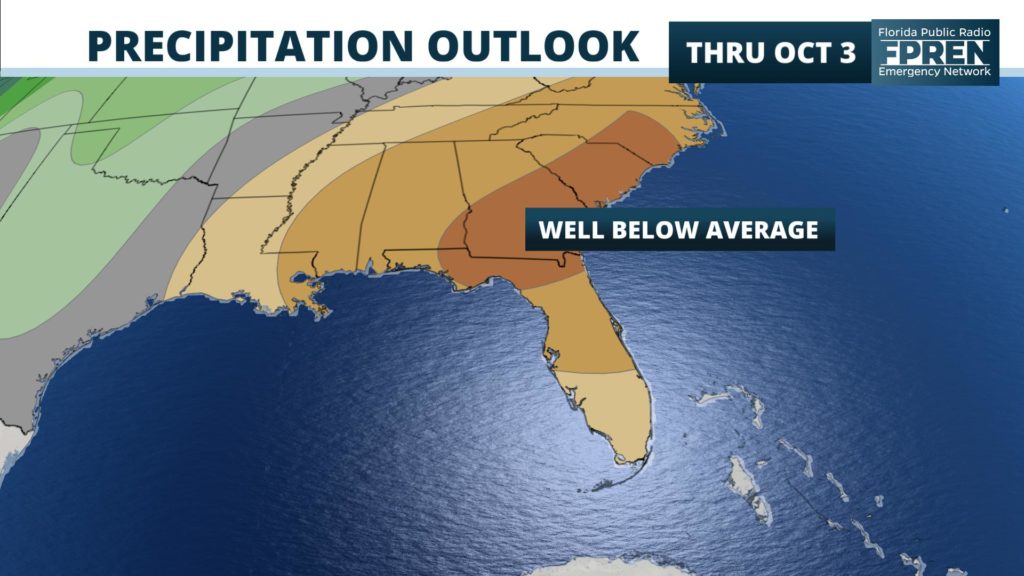
Recent forecast data also suggests the dry pattern will continue through at least the beginning of October, as yet another ridge of high pressure is set to build across the Southeast. Above average temperatures and dry air accompanied by the high will likely persist, allowing the drought to continue or even become more severe.
It would appear the only change for significant rain in Florida’s near future might be from a tropical weather system, which is not expected in the next five days. However, tropical weather activity is still very possible over the next few weeks, based on historical data that suggests the height of hurricane season continues through mid-October.


