Tropical storm conditions and a dangerous storm surge are just hours away from reaching the Florida’s Big Bend and the Nature Coast.
Rainfall intensities and the risk of tornadoes are also on the increase overnight as Tropical Storm Nestor nears Florida's Panhandle by daybreak.
And here's another reminder: The greatest impacts from Tropical Storm Nestor will spread more than 200 miles from the center.
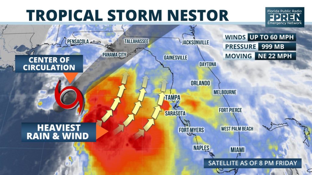
A Storm Surge Warning continues from Indian Pass to Clearwater Beach, where a large and expanding area of onshore tropical storm force winds are expected to push the water into the coast for hours. An inundation of three to five feet above normally dry ground is possible from Indian Pass to Crystal River, including the vulnerable low-lying areas around Cedar Key. An inundation of 2 to 4 feet of water above dry ground is possible from Crystal River to Clearwater Beach, with 1 to 2 feet of surge possible in and around Tampa Bay.
A Tropical Storm Warning is in effect from the Alabama state line to the Nature Coast. Inland Tropical Storm Warnings are also in effect for the entire Floridan Panhandle, including Tallahassee, Marianna and Crestview. By daybreak, the rain bands will only grow stronger and spread farther inland from Panama City to Tampa. Winds of 40 to 50 mph, with occasional gusts to 60 mph will be possible in the areas
PENSACOLA AREA
The Tropical Storm Warning has been cancelled for inland Santa Rosa and Escambia counties, but a High Surf Warning continues along the coast. The heaviest rain and strongest winds are expected to stay well east of the area, but occasional downpours and gusts 30 to 40 mph will be possible overnight. Seas will be rough on Saturday and there will be high risk of rip currents, although skies should gradually clear throughout the day.
PANAMA CITY AREA
Periods of heavy rain will continue through noon Saturday, and most areas will likely receive a storm total of 2 to 4 inches. Tropical storm wind gusts up of in the 40 to 60 mph range could occur in the strongest rain bands, and this is also when an isolated tornado is possible. The highest storm surge of 3 to 5 feet is expected east of Indian Pass, but some coastal flooding is likely near Mexico Beach and Panama City Beach at times of high tide early Saturday morning.
TALLAHASSEE AREA
The heaviest rain bands will begin after midnight and last through noon Saturday. Most areas will likely receive a storm total of 3 to 5 inches. Even though the region has been in a drought, repeating downpours with high rainfall rates could lead to flash flooding in some areas. Tropical storm wind gusts of 40 to 50 mph could occur in the strongest rain bands, and this is also when an isolated tornado is also possible. The highest storm surge of 3 to 5 feet is expected along the Big Bend, east of Indian Pass. The highest water levels will occur around high tide Saturday morning, which is at 5:31 am near St. George Island.
JACKSONVILLE AREA
The heaviest rain will reach northeast Florida in the midday hours Saturday, and storm totals will likely range between 1 and 2 inches in most areas before it ends Saturday night. Wind gusts up to 40 mph and an isolated tornado are also possible when some of the stronger rain bands rotate through.
GAINESVILLE, OCALA AND NATURE COAST
A storm surge of 3 to 5 feet is possible along the Nature Coast, with the water reaching the highest levels during times of high tide at 5 am early Saturday. The heaviest rain bands will move through overnight and last through midday Saturday. Storm totals will range from around 3 or 4 inches near the coast, to 2 or 3 inches farther inland.
Wind gusts of 40 to 50 mph are possible in the stronger rain bands near the coast, with gusts up to 40 mph possible near Gainesville and Ocala, where a Wind Advisory is also in effect. An isolated tornado is possible with any thunderstorm activity early Saturday.
TAMPA, ST PETE AREA
A storm surge of 2 to 4 feet is possible along the coast from Clearwater Beach north, with the water reaching the highest levels during times of high tide early Saturday. Periods of heavy rain will continue through Saturday morning, tapering off some by midday Saturday. Wind gusts up to 45 mph could occur during the stronger rain bands, and this is when an isolated tornado is also possible. The risk of tornadoes is greatest immediately along the coast between 11 pm and 5 am. Rain totals will range from 2 to 4 inches near the coast, tapering off to 1 to 3 inches farther inland.
ORLANDO AREA
The heaviest rain will move through Central Florida Saturday morning and midday, gradually tapering off by early evening. Rainfall totals will likely range between 1 and 2 inches in most areas. Wind gusts up to 30 mph and an isolated tornado are also possible when some of the stronger rain bands rotate through.
SOUTH FLORIDA
A few showers or thunderstorms are possible Saturday and Saturday evening, although the rain is not expected to be widespread. Breezy south winds will gust to 25 mph at times Saturday and Sunday, resulting in rough seas and choppy inland waterways.
The tropical storm is expected to move ashore in the Florida Panhandle Saturday, and this is when a large area of heavy rain and gusty winds will rotate across portions of north and central Florida. The National Weather Service has placed most areas of the state north of I-4 under a “marginal risk” of severe weather, advising that an isolated tornado will be possible with any embedded thunderstorm activity that develops in the heavier rain bands.
The relatively fast movement of the storm is likely to mitigate the inland flood potential, although rainfall rates in some areas might be high enough to cause localized flooding of low-lying or poorly drained areas. Rainfall totals from the storm north of the I-4 corridor are expected to range from 2 to 5 inches near the Gulf Coast, to 1 to 3 inches farther inland. Lesser and more widely scattered amounts of rain are expected across portions of south and southwest Florida.
The tropical storm is forecast to exit the state Saturday afternoon and evening, taking most of the rain and adverse weather with it. A much drier and calmer day is expected across Florida on Sunday, although breezy conditions may continue and the risk of rip currents might be elevated at all area beaches.


