Multiple rounds of showers and thunderstorms are expected across the northern third of Florida through Wednesday, and some of them could produce wind damage or hail. Beneficial amounts of rain are also expected, since the region has been experiencing a drought recently.
The same front that produced dozens of tornadoes from the Mid-South to the Mid-Atlantic states slowed to a crawl as it neared the Florida-Georgia border early Tuesday morning. Moisture from the Gulf of Mexico began moving in along the front, triggering numerous clusters of showers and thunderstorms that stretched from the Nature Coast to the First Coast.
The morning rain have likely stabilized the air temporarily, so any shower or thunderstorm activity that redevelops through early Tuesday afternoon should remain relatively weak. However, the nearby presence of the front and added lift from weak disturbances moving along it will keep the risk of thunderstorms in the forecast for these areas through at least Wednesday.
The onset of each episode of thunderstorms through the period will be when the risk of damaging wind gusts or hail would be greatest. The timing and location of such events is difficult to pin down at the time, based largely on the finicky nature to the disturbances, but there will likely be a general trend of thunderstorms firing first near the Nature Coast or Big Bend region and moving east toward the First Coast. The next round is likely to develop late Tuesday afternoon or evening in the Suwannee River Valley and move generally along the I-10 corridor toward Jacksonville. Subsequent rounds late Tuesday night and Wednesday will likely follow a similar path, with the strongest cells capable of producing heavy rain, frequent lightning, gusty winds and small hail.
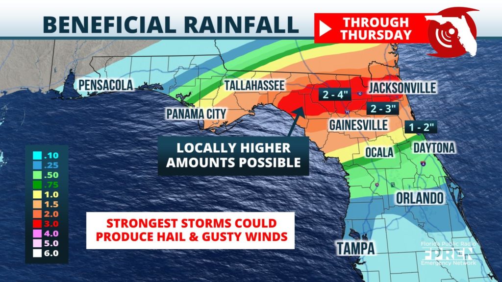
One to three inches of rain is forecast over a wide swath of North Florida through Thursday, with the potential for locally higher amounts near the strongest, most persistent thunderstorms. Rain gauges and radar estimates indicate that 1 to 3 inches of rain has already fallen since Monday morning from the Live Oak and Lake City areas to the Jacksonville metro area and south to Gainesville. These rainfall amounts may cause pockets of flash flooding, but are far more likely to be of help from the developing drought. The most recent drought monitor includes nearly all of North Florida in a moderate drought. The new rain is likely to at least prevent the drought from getting worse, if not temporarily cause improvement.


