Flooding rains along portions of Florida’s Treasure and Gold Coasts are poised to move up the peninsula this weekend.
A cold front which brought cooler, drier air to much of central and north Florida earlier in the week has stalled over south Florida. Deep tropical moisture high in the atmosphere, partially tied to newly-formed Tropical Depression 25 in the western Caribbean, is expected to gradually develop northward over the upcoming weekend.
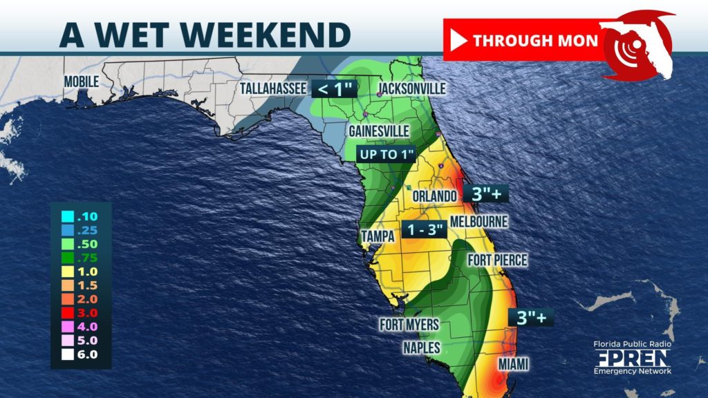
The National Weather Service has continued Flood Watches into the weekend for both the Treasure and Gold Coasts. Many areas in Martin and St. Lucie counties have had more than 9 inches of rain over the past several days, and an additional 2 to 4 inches are possible through Friday night. This new rain may cause flooding of urban areas and exacerbate existing flooding in areas that are already saturated.
Farther north, widespread rainfall of 1 to 3 inches is becoming more likely toward the I-4 corridor, beginning on Saturday and lasting into Saturday night and Sunday. Locally higher totals exceeding 3 inches are possible, if not likely, according to forecasters at NOAA’s Weather Prediction Center. Heavy rain could expand as far north as the First Coast, Gainesville, and Lake City on Sunday, but there is more uncertainty in the threat of flooding in these areas because of dry air that is firmly entrenched in those areas.
Moisture high in the atmosphere from Tropical Depression 25 is likely to enhance rainfall over the Florida Peninsula. However, the latest forecast track from The National Hurricane Center takes the depression westward toward Mexico’s Yucatan Peninsula on Saturday and then farther west into the southwestern Gulf of Mexico early next week. If this track holds, the state of Florida would not experience direct effects from this tropical system.
Much of the Florida Panhandle is likely to stay dry over the upcoming weekend as high pressure nosing southward from the Appalachians maintains greater control over the weather in that part of the state.


