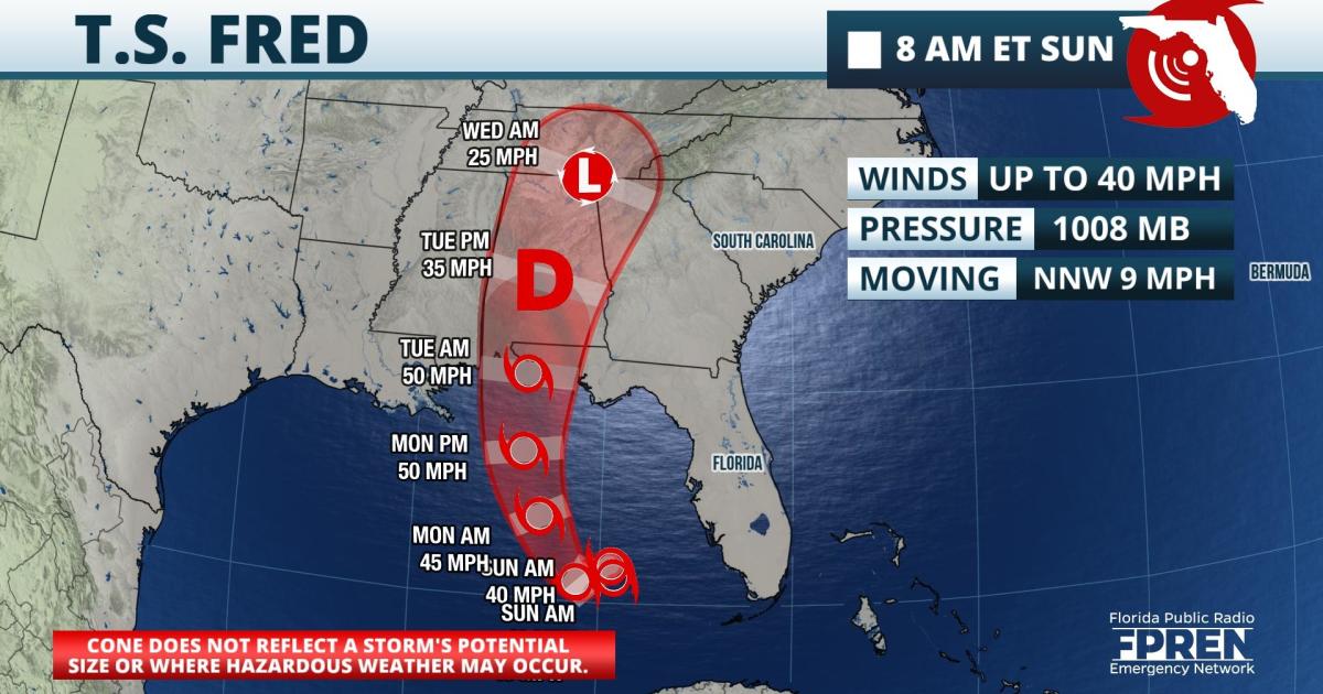
Update as of 9:45 AM Sunday: Hazards such as heavy rain and potential flooding are still possible on Sunday, but the worst effects from Fred are expected to stay out over the Gulf and head for the Panhandle. Flood Watches continue for much of South Florida until Sunday evening, where an additional 2 to 4 inches of rain may fall in a few locations.
Tropical Storm Watches are in effect for much of the Florida Panhandle and the National Hurricane Center says those are likely to be upgraded to warnings later Sunday morning. 4 to 8 inches of rain are forecast in the Panhandle and there is a chance of tropical storm force winds Monday afternoon and night.
Update as of 11:30 AM Saturday: Strong wind shear has taken its toll on Fred and it is no longer a tropical depression based on the 11am advisory from the National Hurricane Center. The tropical wave is forecast to become a tropical storm over the Gulf of Mexico some time late Sunday before heading for the western Florida Panhandle or Alabama on Monday. Regardless of its status, heavy rain is likely to be the primary threat and a few, brief tornadoes are still possible this weekend.
Flood Watches continue in effect for South Florida where 3 to 5 inches of rain and local amounts to 8 inches are capable of causing flooding on already saturated ground.
 Original Story from Friday Evening: Tropical Depression Fred remained disorganized Friday, and the National Hurricane Center (NHC) says forecast confidence continues to be "lower-than-normal". However, hazards such as heavy rain, potential flooding and possible tornadoes are still expected in south and southwest Florida, including the Keys and greater Miami.
The Tropical Storm Warning continues over the Keys and the Straits of Florida, including Florida Bay. A Tropical Storm Watch remains in effect farther north from Blackwater Sound to Bonita Beach.
The primary hazard that will affect most South Floridians from Fred is still likely to be heavy rain and potential flooding. However, tropical storm force wind gusts and high seas are also possible as early as Friday night in the aforementioned areas of Southwest Florida under the warning. Isolated tornadoes are also possible across all of south and southwest Florida Saturday in some of Fred's stronger outer rain bands.
Fred's fragmented center of circulation is now moving due west, skirting the island of Cuba and being hindered by wind shear (varying speeds and direction with height). The storm has also slowed in forward motion over the past 24 hours, and interactions with land have unraveled many of the rain bands or thunderstorms from the center. A somewhat more favorable environment for intensification awaits the season's sixth named storm in the southeastern Gulf of Mexico, but only if it can navigate the Straits of Florida and the Florida Keys Saturday cohesively. Forecasters at the NHC have also noted that recent model guidance suggests a center re-formation may occur, which could further complicate the forecast.
As of 5 pm EDT Friday, the official NHC forecast track of Tropical Depression Fred includes a shift to the left (or west) and much later turn to the north compared to recent advisories. The intensity forecast also now calls for more strengthening prior to landfall in the Florida Panhandle, which would be more likely to occur Monday given the slower near-term motion and more westward track.
None of the complications surrounding Fred's forecast are a surprise, according to the NHC's Senior Hurricane Specialist Dan Brown. In his 5 pm forecast discussion, he noted that "model shifts" are common with disorganized systems and reminded users not to focus on the exact forecast track. He further stated that hazards such as heavy rainfall, gusty winds and a chance of tornadoes are still likely to occur in Florida, despite the recent shift.
9(MDA5NDY0MjA5MDEzMzcwMjQ4MTUxZWMwMg004))
