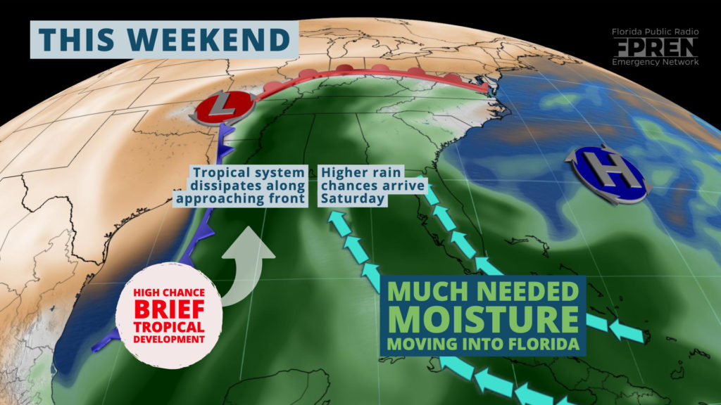
A short-lived tropical depression is likely to form over the Gulf of Mexico Friday, before merging with an approaching front this weekend.
The system is not expected to be a significant threat to Florida, but it could bring more beneficial rain to parts of the Sunshine State through at least Monday.
The National Hurricane Center said showers and thunderstorms over the Bay of Campeche were “becoming better organized” Thursday evening, and that further development was anticipated overnight. Forecasters also mentioned that if a tropical depression formed, it would most likely be short-lived. Regardless, gale force winds were expected across the western Gulf of Mexico Friday and Saturday thanks to an approaching cold front.
Florida is unlikely to be in the crosshairs of any tropical weather hazards, but unsettled weather may develop across portions of the state for a second straight weekend.
Residents of the Florida Panhandle might consider this good news, as many were left with far less rainfall than hoped for last weekend from Subtropical Storm Nestor.
Beneficial rain is in the forecast for several days across Florida, but the weekend is not expected to be a washout in any given location.
The interactions of the approaching front, the potential tropical system, and an area of high pressure over the western Atlantic Ocean will induce a deep southeast flow over Florida. A warm and humid tropical air mass will be transported north by the clockwise circulation to our east and counter-clockwise motion to our west. This pattern is likely to remain in place over the peninsula through at least the beginning of next week.
Rain chances will be at their highest when a piece of energy or frontal boundary lifts the tropical air mass and produces organized areas of showers and thunderstorms. Forecast data suggests this is most likely to occur across portions of South Florida Friday, then spread into central and northern sections of the state late Saturday and Sunday. Pockets of heavy rain will be possible in some areas, especially where stronger thunderstorms occur. Outside of these areas, widely scattered showers are possible across the entire state at any time Friday through at least Monday.
Rainfall amounts are likely to vary greatly across Florida through Monday, but there are two areas more susceptible to meaningful amounts on a wider scale. One of those areas will be southeast Florida near Fort Lauderdale and West Palm Beach, where 1 to 2 inches are projected by the Weather Prediction Center (a branch of NOAA) thanks to the persistent wind out of the southeast from the Atlantic Ocean. The aforementioned front is likely to slow down as it approaches the Florida Panhandle, which is where another widespread area of greater than one inch of rain may fall through Monday.
Rain chances are expected to stay elevated across the northern half of the peninsula early next week, where the front will likely stall. Whereas areas farther north and west will likely dry out for a few days, thanks to drier air moving in behind the front.


