Flooding, high winds, and tornadoes are possible in Florida Thursday as yet another strong storm system sweeps across the state. This will be the fourth front in as many weeks, and it could be the strongest.
The area of low pressure was noted to be rapidly developing in the Gulf of Mexico Wednesday, where it is forecast to quickly strengthen overnight. The center of the low will approach the Florida's Big Bend region Thursday, but impacts will be far-reaching and likely felt across all of Florida.

Flooding is the primary hazard in portions of the panhandle and north Florida, where many rivers are already above flood stage and the flooding is likely to worsen in the days following. Severe thunderstorms capable or producing wide swaths of wind damage or isolated tornadoes are possible in portions of central and south Florida Thursday and Thursday night. And unique to this storm will be the powerful winds behind it, producing dangerously high seas and gale conditions along nearly every coastline.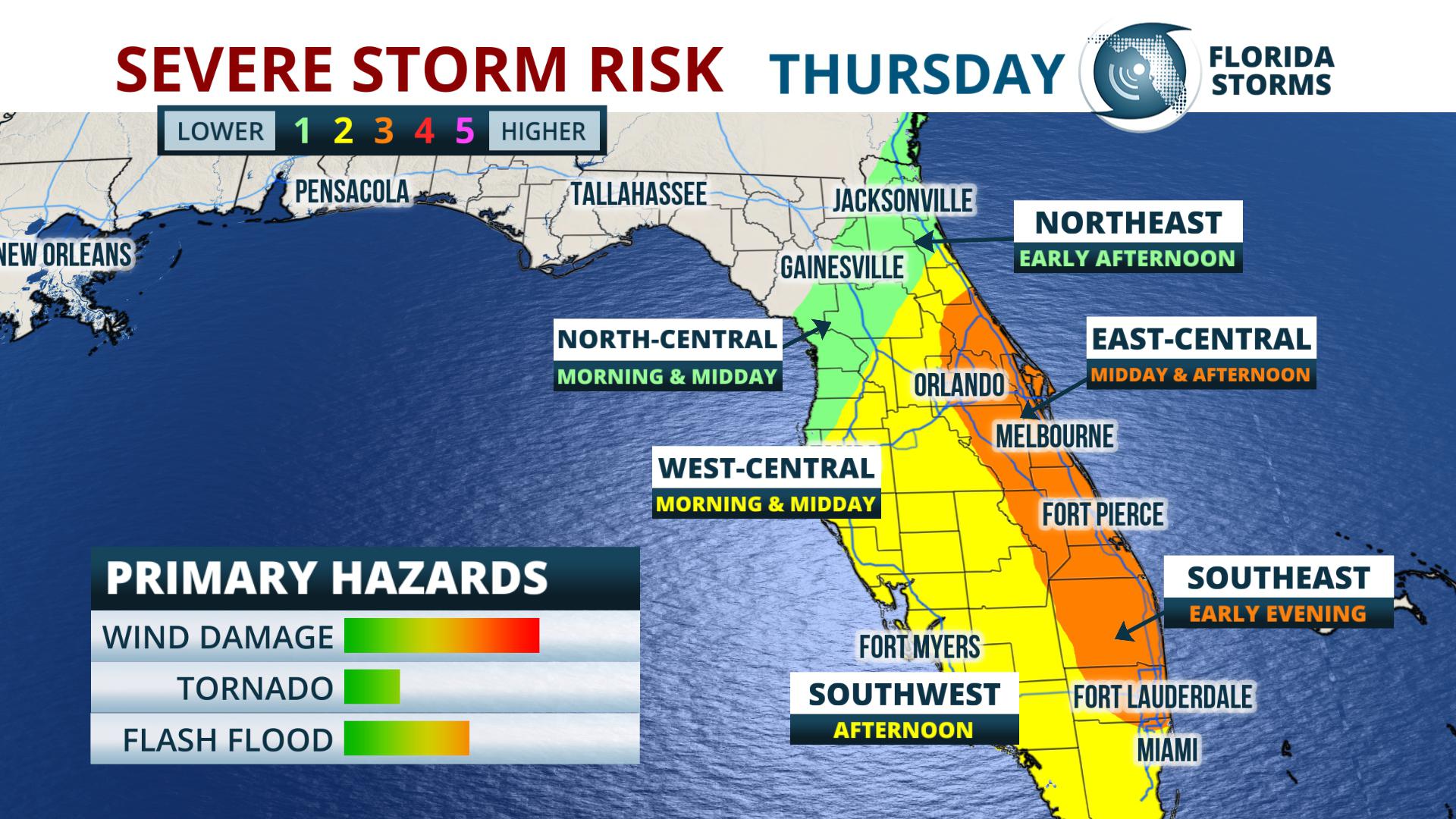
A squall line of thunderstorms is forecast to develop along the advancing front in the Eastern Gulf of Mexico early Thursday morning, then race across central and southern sections of the peninsula during the day. Wind gusts to 70 mph will be possible from the strongest cells, where an isolated tornado can't be ruled out. Some areas may experience multiple rounds of thunderstorms before the front clears the state Thursday evening, and the greatest risk area is across the eastern half of the state from Orlando to Miami, then points east from the First Coast to the Treasure Coast.
A Flood Watch goes into effect overnight from Panama City to Jacksonville, then points south and west to just north of Tampa. Widespread rainfall totals of 2 to 3 inches are expected in the watch area, with isolated amounts of 4 to 5 inches possible in some areas. The rain may fall at a high enough rate to produce temporary urban or small stream flooding, but the larger concern will be the additional water flowing into many rivers that are already above flood stage.
Residents in flood prone areas along the following rivers are urged to prepare now for possible evacuations or inconveniences from the rising waters.
It should be noted that the forecast crests along many of the rivers could be higher, or even further delayed, due to the anticipated rainfall from Thursday's event. Significant rainfall, generally in the 1 to 3 inch range, will also occur across portions of central and south Florida from this front, but many of these areas are experiencing a moderate drought and will benefit from the extra water.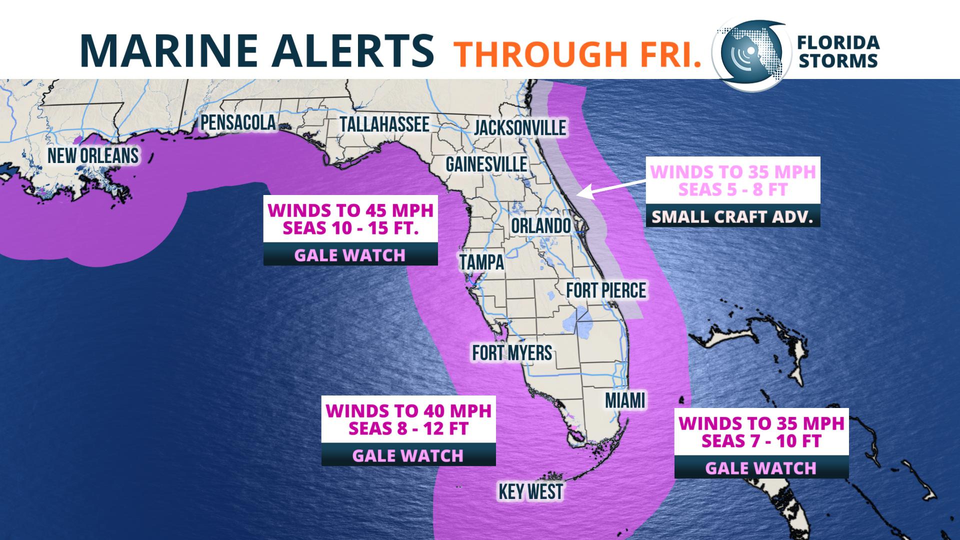
What will make this storm different than the previous three is the strong winds that will follow it. Gale conditions, characterized by wind gusts in the 30 to 45 mph range, are likely along nearly every mile of the Gulf Coast at some point Thursday night and Friday. Gale force wind gusts up to 40 mph are also possible in the offshore waters along the Atlantic Coast Friday and Friday night.
These winds will produce dangerous surf, high seas, a life-threatening rip current risk and coastal flooding in some areas. Peak wave heights will range from 7 to 12 feet along portions of panhandle and Nature Coast, to as high as 12 to 16 feet in portions of west-central and southwest Florida on Friday. Wave heights along the Atlantic beaches are forecast to be 5 to 7 feet high near the First Coast, tapering to the 3 to 5-foot range along the Treasure Coast and in South Florida.


