Another cold front is on the way, but this one deserves context. Millions of Americans in the Midwest likely won't see the mercury rise above zero for days. Thousands of travelers in the Mid-South are about be snarled from snow and a sudden freeze. It's likely to be winter's worst punch for most of the U.S., but it will only be a glancing blow to Florida.
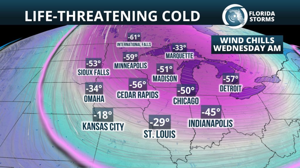
Some of the coldest air in the globe has been recently dislodged from the North Pole, and upper-level steering currents are sending it straight to the United States. The Northern Plains and Great Lakes have already fallen into a deep freeze, and the mercury is likely to keep plummeting here through midweek. Wednesday morning will be downright dangerous to be outside in cities like Chicago, Des Moines, and Minneapolis, where temperatures and wind chills will dive dozens of degrees below zero.
The arctic front is headed south Tuesday, where a couple of inches of snow are expected to quickly accumulate across portions of Louisiana, Mississippi, Alabama and Tennessee. This will be followed by temperatures tumbling below freezing and potentially producing area of black ice from New Orleans to Atlanta.
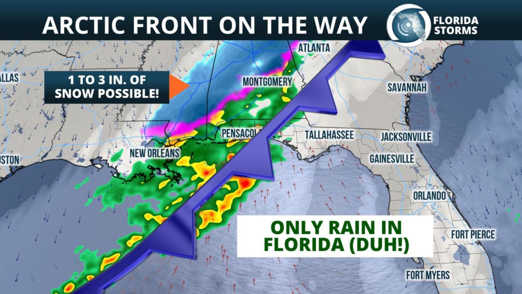
Showers will mark the arrival of the front in much of Florida Tuesday, but the rain will be nowhere near as heavy or long-lasting as Sunday's system. The rain will first enter the Florida Panhandle Tuesday morning, then move across portions of North Florida by late afternoon. The front is then likely to weaken as it passes through central and south Florida, where showers will be sparse.
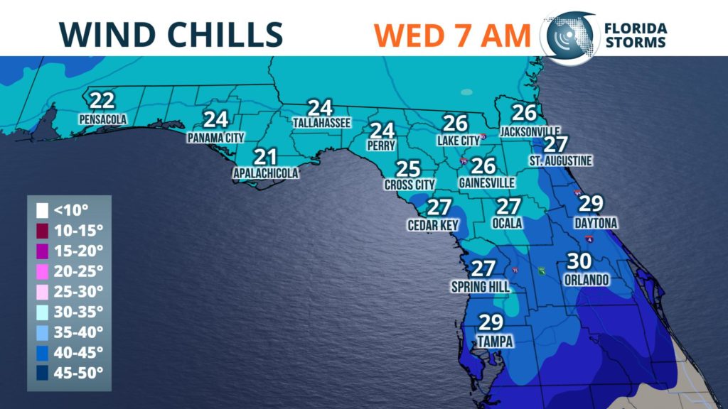
Behind the front, a northerly wind will usher in a brief blast of the modified arctic air. A light freeze is likely across most of the Florida Panhandle, stretching to potentially as far south as Alachua County in northern sections of the state. The wind will make it feel colder at times, and wind chills are expected to fall into the 20's by Wednesday morning for a large area of Florida north of the I-4 corridor. The coldest wind chills are likely to be felt near Pensacola, where the 'feels like' numbers could briefly dip into the upper teens.
Wednesday and Wednesday night will also be quite cold across the Sunshine State, with daytime highs likely struggling to reach the 50's in the panhandle, then only ranging from the middle 50's in north Florida to the 60's further south. A freeze and/or frost is then expected across most inland areas north of I-4 Thursday morning.
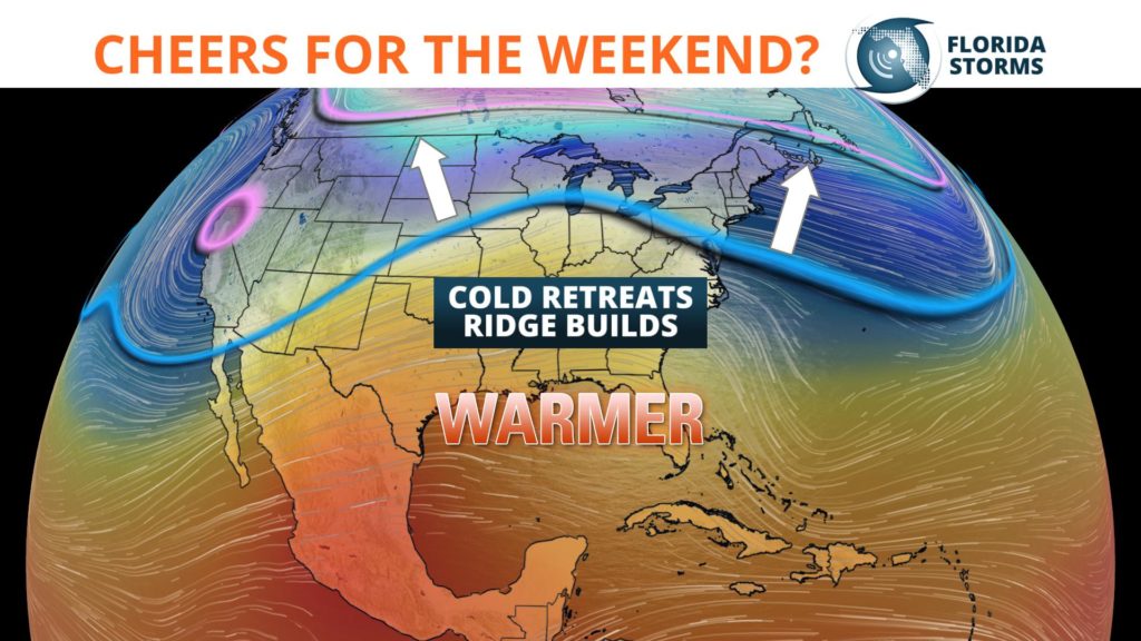
The cold snap that is about to hit Florida is not unusual for this time of year, no where close to breaking records (like it will further north), and it won't last very long. This is because strong upper-level winds from the southwest are expected to replace the arctic intrusion with milder, Pacific air by week's end. In fact, long range forecast data suggests there could be a prolonged period of above normal temperatures headed to the Southeast U.S. starting this weekend. Rain chances might also accompany the warm up though, which has been a recurring theme this winter in Florida.


