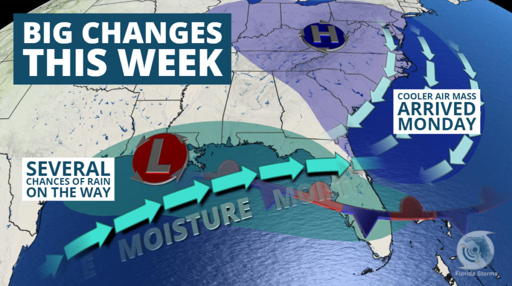
More than 50 record highs have been set in Florida this month, but that will come to an end this week thanks to a shift in the upper-level winds and increasing chances of rain.
Evidence that a change was occurring could already be seen Monday morning, with cooler temperatures running 10 to 20 degrees cooler in many areas behind a cold front.
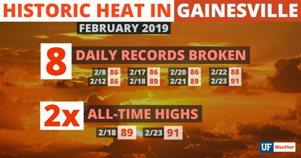
The cooler air that arrived Monday isn’t anything unusual for late February, but it will be noticeable considering how warm it has been across the Sunshine State recently. No city has had a warmer February than Gainesville, where eight day record highs have been broken and the all-time warmest temperature was recorded. Twice.
Gainesville isn’t alone. The February warmth has been widespread. Every climate reporting station across the state has recorded well-above normal temperatures so far this month. Departures from normal and where they rank (as of February 24th) in the history books are listed below.
| Pensacola: +9 (4th) Tallahassee: +9 (3rd) Jacksonville: +8 (3rd) Gainesville: +11 (1st) Daytona Beach: +8 (2nd) Orlando: +7 (2nd) Tampa: +8 (2nd) | Melbourne: +6 (6th) Sarasota: +5 (3rd) Fort Pierce: +7 (8th) Fort Myers: +6 (2nd) West Palm Beach: +6 (5th) Miami: +5 (3rd) Key West: +6 (1st) |
As of February 23, NOAA had verified that 49 daily record high temperatures were set across the state this month alone. We know of at least one more that occurred Sunday in Vero Beach and there are likely to be a few more added after verification. We’ve listed all of the official numbers in the table below.
[table id=7 /]
The record-setting air mass is unlikely to return anytime soon, thanks in large part to added cloud cover and higher rain chances that are in the forecast most of the week. The upper-level winds will steer a series of storm systems across the peninsula over the next six days, with the first slated to arrive Tuesday. The interaction of a nearby front and the approaching disturbance is likely to trigger a few showers across portions of the Florida Panhandle in the morning hours, spreading southeast along the Nature Coast and into much of central Florida by Tuesday afternoon.
Daytime highs will range from the upper 60’s across northern sections of the state, to the middle and upper 70’s elsewhere. This is a far cry from the widespread 80’s experienced in recent days, but much closer to the seasonal norms in Florida for late February.
The active weather is forecast to continue through the upcoming weekend, with several more chances of rain, and even a few thunderstorms at times, keeping daytime temperatures from hitting record levels. Although they are forecast to be near or above average for this time of year.


