Powered by WUFT
Temporarily change filter
Finding your station


Update 5:00 PM Monday: The season’s third tropical depression has formed between the Bahamas and Florida.
The National Hurricane Center says it’s located about 120 miles southeast of West Palm Beach as of the 5 PM advisory. Maximum sustained winds are near 30 mph. The depression is moving toward the northwest at 13 mph.
The depression is not forecast to reach tropical storm status. There are no changes to the forecast of locally heavy rain and gusty winds outlined in the 3 PM update below.
Update 3:00 PM Monday: The strong tropical wave has improved its organization today. For this reason, the National Hurricane Center increased the chances of the tropical wave becoming a tropical depression to 60% in its 2 PM tropical outlook.
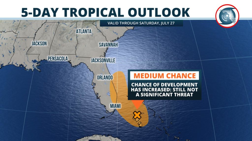
Data from satellite suggest a closed circulation may be forming over Andros Island. If this trend persists and is confirmed by National Hurricane Center forecasters, the tropical wave may become a tropical depression Monday night or Tuesday morning.
Most of the computer model simulations forecast the tropical wave or depression to pass near or just offshore of Palm Beach and Martin counties early Tuesday morning before an approaching front turns it out into the Atlantic. Should this scenario occur, the heaviest rain and some gusty winds will be near the coast or just offshore. However, if the developing system tracks slightly farther west — which is possible but unlikely — heavier rains would move inland and affects parts of Broward and Miami-Dade counties, as well.
The developing system will not have a lot of time to organize: stronger wind shear and the approaching front should prevent this from becoming a strong tropical storm or hurricane as it turns northeastward into the Atlantic later Tuesday into Wednesday.
Meteorologist Ray Hawthorne authored this update. The original story, as posted Sunday evening, is below.
Hurricanes and cold fronts can both produce hazardous weather in Florida. The good news is they usually can’t coexist.
A formidable tropical wave will be approaching Florida this week, while at the same time an unusually strong mid-summer front will be sliding into the Southeast. The front is forecast to win this battle, sparing Florida and the United States a significant tropical threat.
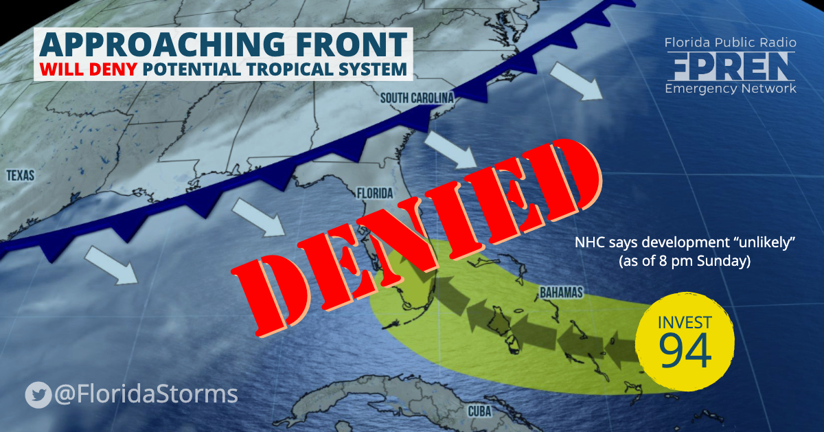
Invest 94 Unlikely to Develop
The tropical wave, referred to as “Invest 94” by meteorologists, was producing a disorganized area of showers east of the Bahamas Sunday afternoon and moving west at 15 mph. Forecasters at the National Hurricane Center said it was “unlikely to develop” over the next five days, according to their 8 pm tropical outlook.
Water temperatures may be warm enough in the western Atlantic Ocean for tropical storm formation, but atmospheric conditions are questionable. Strong upper-level winds, the same winds that are steering in a cold front, are forecast to create an environment unfavorable for tropical development over the region. However, the presence of the front and the added moisture from Invest 94 will almost certainly lead to a wet week across the state.
The Front Wins, then Stalls
The idea that a cold front will move through Florida and cool it off this time of year is usually a farce. That’s also the case with this one. It will be strong enough, however, to break the heat wave that scorched the Midwest and Northeast this weekend, and powerful enough to produce numerous showers and thunderstorms ahead of it.
Starting Tuesday, the thunderstorms will be a little stronger and longer lasting than the typical sea breeze activity across the northern half of Florida. The downpours could also arrive much earlier in the day, especially in locations near the Emerald Coast, Florida’s Big Bend, and the Nature Coast. Multiple rounds of heavy rain might also move over some of the same locations in a short amount of time, leading to a risk of localized flooding in these areas.
The front will then likely put on the brakes, slowing to a crawl and eventually stalling across the northern half of Florida by Wednesday or Thursday. Tropical moisture from the nearby tropical wave, combined with a steady stream of moisture moving in from the Gulf of Mexico along the front, will keep the air over central and northern Florida nearly saturated for several days. Showers and thunderstorms are expected to be widespread each and every afternoon along and north of the I-4 corridor through Friday. The activity will generally develop near the Gulf Coast in the early part of the day, transitioning inland and moving toward the First and Space Coasts by early evening.
Further south, most Floridians may not even notice a significant change to the weather pattern this week. Clouds and showers may be a little more prevalent (than normal) in the morning hours, but the typical inland afternoon sea breeze thunderstorms will generally be the rule. One exception to this generalization might be near Miami, Fort Lauderdale and West Palm Beach, where the moisture and energy from Invest 94 might move close enough to produce some heavier rain bands near the coast or just offshore Tuesday and Wednesday.
The tropical wave and stalled front are forecast to dissipate or move east of Florida by Thursday, with a normal mid-summer weather pattern resuming by the end of the week.
1885 Stadium Road
PO Box 118405
Gainesville, FL 32611
(352) 392-5551
A service of WUFT at the University of Florida College of Journalism and Communications


Partners of the Florida Public Radio Emergency Network include: Florida's Division of Emergency Management, WDNA (Miami), WFIT (Melbourne), WMFE (Orlando), WFSU (Tallahassee), WGCU (Fort Myers), WJCT (Jacksonville), WKGC (Panama City), WLRN (Miami), WMNF (Tampa-Sarasota), WQCS (Fort Pierce), WUFT (Gainesville-Ocala), WUSF (Tampa), WUWF (Pensacola) and Florida Public Media.
This page uses the Google Privacy Policy and UF's Privacy Policy
