The most active part of the hurricane season are the months of August, September, and October. In this “State of the Season” report, we will assess trends in atmospheric and oceanic conditions around the globe that may lend clues on how the waters could behave over the next few weeks.
The Season So Far
Two named storms have formed in the Tropical Atlantic Basin through July 31, which is very normal for this part of the season. Andrea, a short-lived subtropical storm in the North Atlantic, formed on May 20 and dissipated the following day. Barry, the season’s first hurricane, got its start as a depression on July 10. It became a tropical storm the next day, then made landfall as a minimal hurricane near Intracoastal City, Louisiana on July 13.
An alternative metric from Colorado State University suggests the first two months of the 2019 Hurricane Season have been below average in terms of overall activity. The Accumulated Cyclone Energy index, or ACE for short, is widely accepted in the meteorological community as a way to gauge how active the tropics have been based on the intensity, longevity and number of tropical storms and hurricanes. As of August 1, the 2019 Hurricane Season has produced 3.6 units of ACE, which is lower than the 30-year average of 7.3.
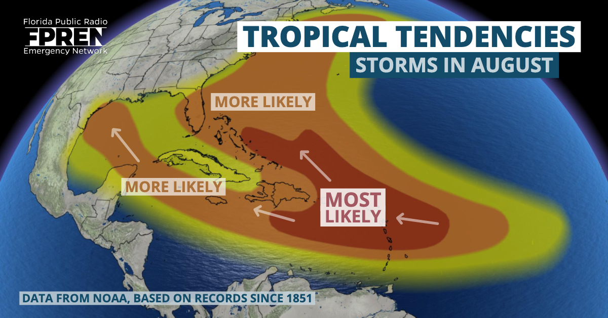
Map represents the general trends of tropical cyclone activity during the month of August.
A Brief Uptick in Atlantic Activity Expected
Sea surface temperatures are warming across the Atlantic Basin, as they always do in late July and August. However, they were much cooler-than-normal over the Main Development Region (MDR) between Africa and the Caribbean in May and June. This has changed dramatically over the past month. The waters are now 1 to 2 degrees (celsius) above normal thanks to changes in global circulation patterns across the North Atlantic Ocean. The anticipated seasonal reduction in wind shear and warming of the waters in the MDR will now make it possible for tropical cyclone activity to develop almost anywhere in the Atlantic, Caribbean or Gulf of Mexico in the next few weeks.
Fluctuations in atmospheric instability can also encourage (or discourage) tropical cyclone development. A type of wave, called a convectively-coupled Kelvin wave (CCKW), can promote tropical cyclone formation if other factors are favorable. CCKWs are tied to thunderstorms near the equator and their release of heat from clouds. They move west to east through the tropics and often difficult to predict, but can be observed. A strong CCKW is moving through the central and eastern Atlantic near the Cape Verde Islands. The combination of warmer waters, low vertical wind shear, and the Kelvin wave are likely to contribute to at least one tropical storm in the Atlantic Ocean during the first week of August.
A strong warming of the upper atmosphere over the North Atlantic and Greenland may have a say on where tropical cyclones may track during the first half of August. This feature, known as the North Atlantic Oscillation (NAO, for short) is not often strong in the summer months, but this season may be an exception. A strong negative phase of the NAO is developing. The negative phase often reinforces troughs of low pressure in the eastern United States and can weaken or disrupt the western extension of the Bermuda-Azores high. Such a pattern often — but not always — causes hurricanes to curve north or northeast before reaching Florida, potentially affecting areas farther north along the eastern seaboard. We want to strongly emphasize that this pattern does not always mean the Southeast U.S. will be spared; it is merely a tendency.
A Lull is Possible by Mid-Month
The strong CCKW should move east and out of the Atlantic Ocean by the second week of August. This would result in sinking air, higher wind shear, and a tendency toward less tropical cyclone development. However, this factor alone does not preclude tropical activity entirely. There are other global waves, such as the Madden-Julian Oscillation (MJO), which can create an environment favorable for tropical storms and hurricanes. At the current time, there is some disagreement between the global models as to where the MJO will be most active, but they seem to favor the area near Indonesia. If this is correct, odds would favor more typhoons in the western Pacific Ocean during the second week of August and less activity over the Atlantic Ocean.
Late August through October
It is nearly impossible to predict what type of impacts equatorial waves (like the MJO and CCKWs) might have on tropical storm and hurricane formation over the Atlantic beyond a few weeks into the future. However, warmer-than-normal water temperatures over much of the Atlantic and a gradually weakening El Nino in the Pacific tend to broadly favor more tropical activity over the Atlantic as we approach the statistical peak of the season.
The next “State of the Season” update is scheduled on or around August 15.
Meteorologist Jeff Huffman contributed to this story.


