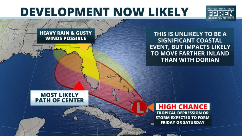
A tropical wave moving through the southeastern Bahamas is likely to bring heavy rain and gusty winds to parts of Florida this weekend, and there is an increasing chance it will become a tropical depression or storm as it does.

The disturbance, now identified by meteorologists as Invest 95, is expected to move toward the west-northwest along the periphery of a strong high pressure ridge. This ridge has been responsible for the stretch of dry, hot weather over the Southern United States in recent days. A weakness in the ridge is expected to develop this weekend, which is key to the future development and track of Invest 95.
The official 5-day tropical outlook is provided in the section below as a point of reference.
Regardless of whether a tropical depression or storm forms, numerous downpours with gusty winds are forecast to develop, especially Friday night and Saturday over the Florida Peninsula. Depending on the track of the tropical system, the unsettled weather may also reach the Panhandle and Big Bend Saturday night or Sunday. The latest official forecast from NOAA’s Weather Prediction Center shows 1 to 3 inches of rain over parts of the state, but that is subject to change pending the track of the tropical disturbance.
The widespread rain (without anything else) would be good news for some residents of the Florida Panhandle. A moderate drought has developed in some counties over the past few weeks according to the U.S. Department of Agriculture's Drought Monitor Index.
4/4 - Either way, some rain appears to be coming. Let's hope it gets to the #BigBend or #Panhandle -- there are some areas there (near #Tallahassee and west of #Marianna) that are in a drought. #flwx #tropics pic.twitter.com/7ebDvTQ9BS
— Ray Hawthorne (@ray_hawthorne) September 11, 2019
Strong westerly upper-level winds and nearby pockets of dry air are the primary reasons why the tropical wave is unlikely to develop through Thursday. However, the upper air environment is forecast to become more favorable for the tropical wave to strengthen starting Friday. An upper-level low pressure area in the eastern Gulf — which is imparting the wind shear — is forecast to weaken and move into the western Gulf. A ridge of high pressure is more likely to build over the tropical wave, reducing the wind shear. The National Hurricane Center forecast as of midday Wednesday has a 60% chance of development this weekend over the eastern Gulf of Mexico.
The forecast models have a variety of possible forecast tracks for this tropical wave. The global model suite run in the United States — called the Global Forecast System, or GFS for short — project a depression or tropical storm to head more toward the central Gulf coast. If this is correct, there would be a greater chance of rain in the Big Bend and Panhandle where pockets of moderate drought have developed according to the latest Drought Monitor. Meanwhile, the European global model — called the ECMWF — and its ensemble suite show also suggest a depression or tropical storm tracking over the far eastern Gulf. Such a path would favor more rain over the Peninsula and Big Bend areas and less over the western Florida Panhandle. These differences in the models are not uncommon, especially in the development phase of a tropical cyclone.
Specifics on the more likely path and strength of Invest 95 may not be responsibly projected until Thursday afternoon or evening. We invite you to check back in with us often as the weekend (and Invest 95) approaches.
