Wednesday morning update: Tropical Storm Imelda came ashore in southeast Texas Tuesday evening and has weakened, but it will continue to produce heavy rain and possible flooding as a remnant tropical low through the day Wednesday.
Tropical Depression Ten intensified early Wednesday morning and became the season's tenth named storm, Tropical Storm Jerry.
Hurricane Humberto intensified into a category 3 storm overnight, becoming the season's second major hurricane.
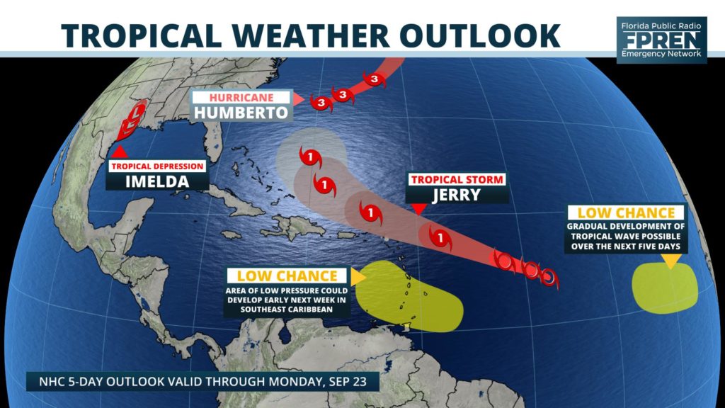
A new tropical storm and tropical depression formed Tuesday, both within a span of two hours. Neither are a threat to Florida at the present time. However, water enthusiasts on the Atlantic coast are still urged to be mindful of dangerous beach hazards from Hurricane Humberto through the end of the week.
The remnants of Tropical Storm Imelda is likely to produce flooding rains across portions of southeast Texas through Wednesday, while Tropical Storm Jerry is poised to strengthen in the central Atlantic Ocean this weekend. Meanwhile, Hurricane Humberto is pulling away from land, but intensified to a category 2 storm Tuesday and is still producing hazardous coastal conditions across the Southeast.
HURRICANE HUMBERTO
Hurricane Humberto is expected to stay over the open Atlantic Ocean, but the storm’s large size has produced dangerous rip currents and large swells from the Mid Atlantic states to South Carolina, Georgia, and Florida. The rip current risk is likely to last a few more days, even as the hurricane moves farther away from the Atlantic seaboard.
A tropical storm warning has been upgraded to a hurricane warning for the island of Bermuda, as forecasters now fear the enlarging wind field will clip the island late Wednesday. Hurricane Humberto is officially forecast to become a major hurricane within the next 24 hours, before weakening over cooler waters in the northern Atlantic late this week.
TROPICAL DEPRESSION IMELDA
Tropical Storm Imelda (pronounced ee-MEHL-dah) was reported to be sitting just offshore of Freeport, TX, about 50 miles southwest of the Houston/Galveston metropolitan area. Forecasters at the National Weather Service are warning of the potential for flash flooding in parts of southeast Texas and southwest Louisiana from the slow-moving tropical storm. Rainfall amounts of 5 to 10 inches, with isolated amounts as high as 15 inches, are expected in these areas through Thursday.
TROPICAL STORM JERRY
Tropical Storm Jerry formed as a tropical depression late Tuesday morning in the deep tropics, roughly midway between the Cape Verde Islands and the Lesser Antilles. Warm ocean waters and light wind shear are expected to create an environment favorable for strengthening, and the latest National Hurricane Center forecast calls for now Tropical Storm Jerry to become a hurricane by Friday morning.
A subtropical ridge of high pressure, which often steers storms through the tropics, is expected to keep the depression moving west-northwestward for the next 4 to 5 days. The official track places the center of what is then likely to be a hurricane over or just north of the northern Leeward Islands on Friday. The projected hurricane is then expected near or north of Puerto Rico and the Dominican Republic this weekend.
A new tropical wave soon to be moving through the far eastern Atlantic has also been identified by the National Hurricane Center as having a “low chance” of developing over the next five days. Rising air motion from equatorial waves and an active train of tropical waves moving off of Africa suggest additional tropical depressions or storms may form next week. However, it is much too early to determine whether Tropical Storm Jerry — or anything that forms behind it — will ever affect the United States mainland.


