An arctic front will send freezing temperatures deep into the Southeast this week, including portions of the Florida Panhandle by Wednesday morning. The front’s arrival Tuesday will be marked by showers or even a brief thunderstorm, followed by a 20-degree temperature drop within just a few hours.
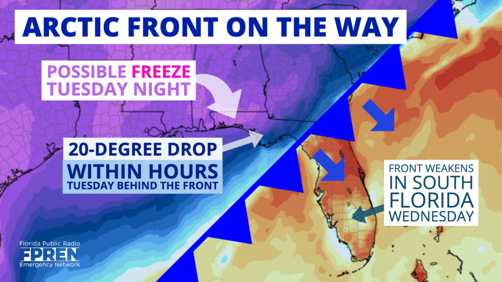
Monday will be a noticeably warmer day across much of the northern third of Florida ahead of the front. Afternoon highs will be in the middle and upper 70’s from Pensacola to Jacksonville, possibly even hitting 80 in a few spots south of I-10. These numbers are near average for mid-November, but normalcy on the thermometer is unlikely to return in these areas the rest of the week.
The powerful front will arrive by daybreak Tuesday in Pensacola, where temperatures are expected to suddenly fall into the 40s by mid-morning, then stay there all day. Farther east, a shocking daytime drop in the mercury is expected from Panama City to Tallahassee, where a brief morning stint in the 60s will be quickly replaced by afternoon temperatures plunging into the 40s.
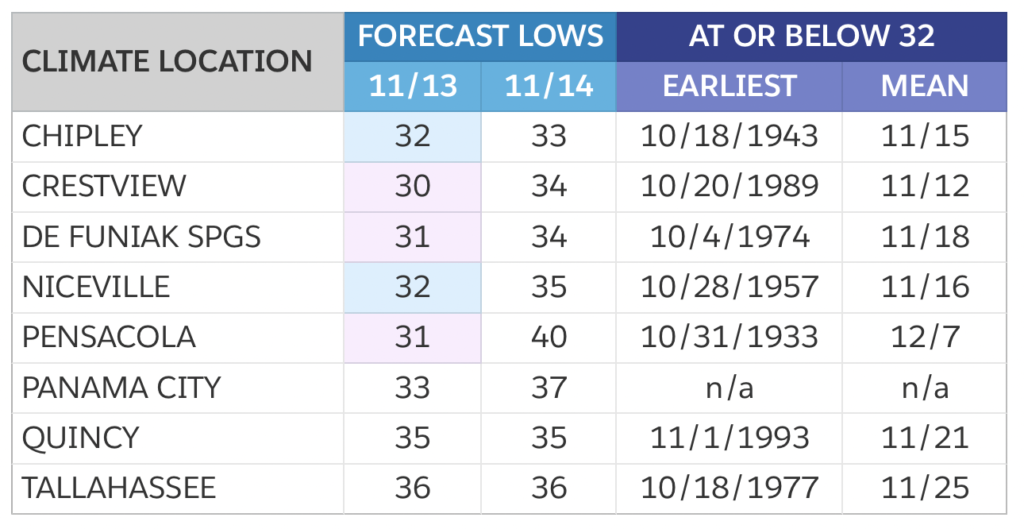
The early winter blast will continue into Wednesday morning, when many locations are likely to experience their first freeze of the season. While this first occurrence of subfreezing temperatures may occur earlier than normal in some locations, the cold snap is not likely to be record-setting. The numbers below were gathered from the National Weather Service climate reporting station data and used for comparison with the projected numbers Wednesday and Thursday morning.
The colder air is likely to spread into north and central Florida Wednesday, where temperatures will also fall below normal for a few days. Afternoon temperatures from Gainesville to Jacksonville might not even hit 60, and Wednesday’s highs in central Florida are likely to stay below 70. Early morning lows in these areas will range from the upper 30s and lower 40s in north Florida to the middle and upper 50s along and north of I-4.
Temperatures are expected to moderate quickly, as they typically do this time of year, across most of Florida by Thursday and Friday. However, the numbers will likely fall short of the seasonal norms through at least Saturday across much of the state due to an increase in cloud cover and possible chances of precipitation beginning Friday.


