A strong storm system is expected to bring tornadoes, hail, and damaging winds to portions of Louisiana, Mississippi, and Alabama Monday afternoon. It could then trigger a few strong storms capable of producing damaging wind gusts in the Florida Panhandle late Monday night or early Tuesday morning.
The factors that are forecast to come together to produce the tornado risk over portions of the Deep South will not be as well aligned for the thunderstorms that move into the Florida Panhandle after early Tuesday morning. However, unstable air streaming northward from the Gulf of Mexico and strong winds aloft have prompted the Storm Prediction Center to place areas west of the Apalachicola River under a “slight” (level 2 of 5) risk for severe weather. In their early morning outlook, forecasters say there is the potential for scattered damaging winds and an isolated tornado, despite the slightly less favorable conditions than farther west.
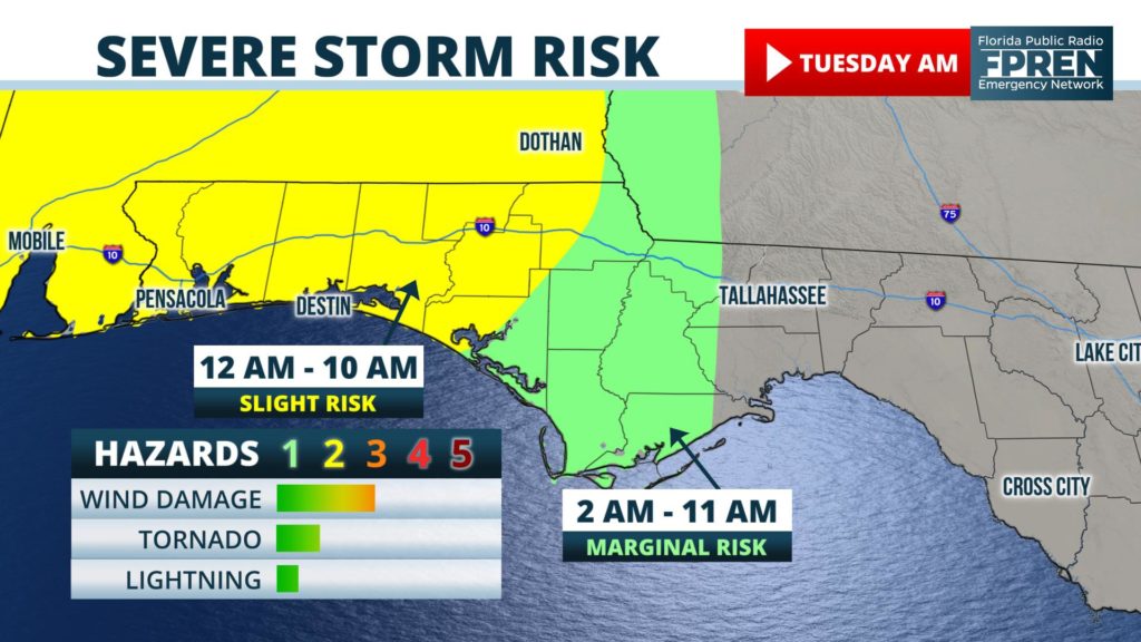
High-resolution computer models show the thunderstorms reaching the Pensacola region between 10 pm and 6 am. They will then spread east into areas from Panama City to Marianna between 2 am and 8 am, followed by the Tallahassee area around or shortly after sunrise Tuesday. Occasional storms may not clear the capital city region until mid-afternoon. Gusty winds, downpours, and lightning are possible with these storms, but the risk of damaging thunderstorms is considerably lower over the central and eastern regions of Florida’s Big Bend.
Much colder air will flow in behind the cold front Tuesday night and Wednesday. A light freeze is even possible over much of the Florida Panhandle, Big Bend, and North Florida by Thursday morning. The greatest chance of freezing temperatures is away from the immediate Gulf coast and closer to Interstate 10, areas that have already experienced a freeze this season.


