English English Spanish Español
Powered by WUFT
Temporarily change filter
Finding your station
THIS STORY HAS EXPIRED

Updated Arrival Times of Saturday’s Squall Line

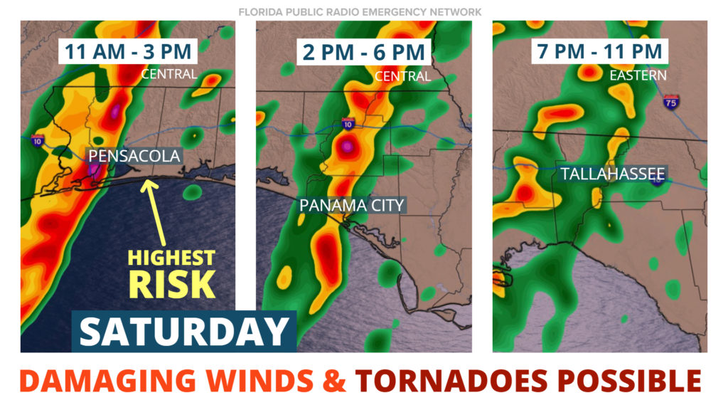
Forecast data continues to suggest a line of destructive thunderstorms will move through portions of the Florida Panhandle Saturday. Confidence is also increasing on when the strongest cells will arrive, which we’ve listed below...

Pensacola: 11 am to 3 pm
Panama City: 2 to 6 pm
Tallahassee: 7 to 11 pm

There are two primary hazards posed by this storm system. First, thunderstorms that develop ahead of the squall line could rotate and produce a tornado. Second, damaging wind gusts in excess of 60 mph are possible along and directly ahead of the leading edge of the squall line.

These hazards will be most likely in the Panhandle. By the time the front arrives to the Big Bend and Northern Florida early Sunday morning, it is expected to have weakened significantly, or dissipate entirely.

LOCAL ALERTS
WEATHER
NEWS
TRAFFIC
Sources include nearest National Weather Service office, National Hurricane Center, and the Florida Public Radio Emergency Network (@FloridaStorms).
Sources include nearby emergency management agencies, FEMA, and your local NPR affiliate. 
Sources include the Florida Department of Transportation, Florida Highway Patrol and other nearby traffic information.

1885 Stadium Road
PO Box 118405
Gainesville, FL 32611
(352) 392-5551

A service of WUFT at the University of Florida College of Journalism and Communications 

Partners of the Florida Public Radio Emergency Network include: Florida's Division of Emergency Management, WDNA (Miami), WFIT (Melbourne), WMFE (Orlando), WFSU (Tallahassee), WGCU (Fort Myers), WJCT (Jacksonville), WKGC (Panama City), WLRN (Miami), WMNF (Tampa-Sarasota), WQCS (Fort Pierce), WUFT (Gainesville-Ocala), WUSF (Tampa), WUWF (Pensacola) and Florida Public Media.

Loading...
linkedin facebook pinterest youtube rss twitter instagram facebook-blank rss-blank linkedin-blank pinterest youtube twitter instagram