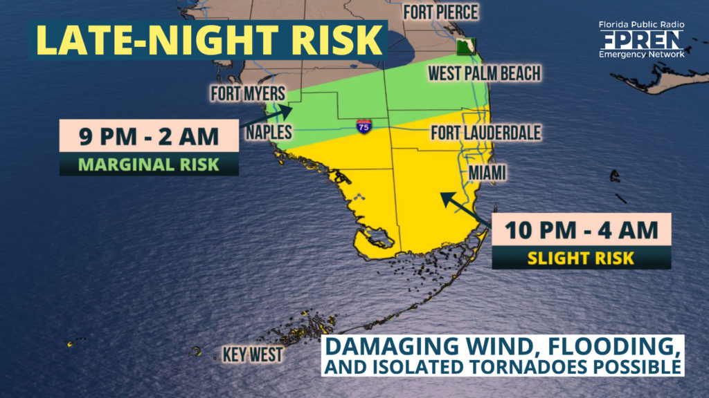
A Severe Thunderstorm Watch is in effect for much of South Florida, including Collier, Monroe, Broward, and Miami-Dade counties until 3 AM.
A line of strong thunderstorms over the Gulf of Mexico is expected to move near Key West around 9:30 PM and progress across the remainder of South Florida between 10 PM and 3 AM.
Damaging, straight-line winds are possible with the strongest storms in the line. The Storm Prediction Center says an isolated tornado cannot be ruled out, but damaging winds are the primary hazard with these storms. Localized flooding is also a concern with the heavy rain accompanying these storms.
Strong thunderstorms are possible across South Florida Friday night into Saturday; a few of which could be capable of producing brief tornadoes. Wind damage and heavy rain are also possible from the strongest cells, all in response to a storm system moving in from the Gulf of Mexico.

Forecasters at the Storm Prediction Center (SPC) and National Weather Service have placed areas near and south of a line from Naples to Fort Lauderdale under a slight risk for severe thunderstorms Friday night, which is a level two out of five on their probability scale. This includes the Florida Keys and Miami. A marginal (lesser) risk is in place for cities farther north, such as Fort Myers and West Palm Beach. There is a similar risk of severe thunderstorms in Saturday’s outlook from the SPC, lasting until the storm system passes early Saturday evening.
The primary risk from the strongest storms are a few reports of damaging wind gusts. SPC forecasters said the tornado risk is greatest between midnight and dawn. During this time, the strongest winds in the lower atmosphere may briefly line up with higher moisture and an upper air disturbance moving through South Florida to produce a brief tornado or two.
Heavy rain and localized flooding is also a concern. Even if tornadoes do not occur, rainfall amounts of 1 to 2 inches are possible over a large area and may cause areas of flash flooding, particularly in vulnerable and urban areas. Locally higher rainfall amounts are possible with persistent thunderstorms that train over the same location.
A lull in the rain and thunderstorms may occur for a brief time on Saturday morning before another disturbance high in the atmosphere arrives during the late morning or afternoon hours. Another round of thunderstorms is expected during the afternoon, which may produce a few more reports of damaging gusts. The threat of tornadoes may be lower with the second round as the winds in the lower atmosphere blow primarily from one direction.
Meteorologists at the Florida Public Radio Emergency Network will be monitoring forecast trends throughout the day Friday, providing updates in this story, on the Florida Storms social media accounts, and in the Florida Storms app. Residents of South Florida in the areas highlighted at risk are encouraged to ensure they have a way of staying informed, and being alerted late at night, to the possible approach of dangerous storms Friday night and Saturday.
