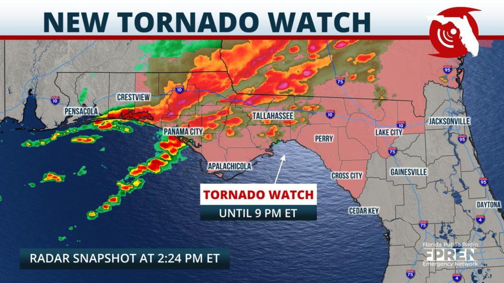
Update Tuesday 2:30 pm ET: A new Tornado Watch has been issued for most of North Florida until 9 PM EST. The watch includes the following counties: Baker, Franklin, Jefferson, Liberty, Taylor, Columbia, Gulf, Lafayette, Madison, Wakulla, Dixie, Hamilton, Leon, and Suwannee.
Update Tuesday 1 pm ET: Forecasters at the National Weather Service have upgraded the previous risk area from “slight” to “enhanced” (or level three out of five) for central portions of the panhandle including areas around Tallahassee.
A Tornado Watch has been issued for the following counties in the Florida Panhandle and Big Bend of Florida until 4 PM EST: Bay, Holmes, Washington, Calhoun, Jackson, Gulf, Walton, Gadsden, Leon, and Liberty.
Locations in the western Panhandle, around Pensacola, are under a “slight” risk along with the Apalachicola region, Lake City, and stretching out towards the Atlantic coast . A “marginal” risk is in place for Florida’s Big Bend and most of northeast Florida including the cities of Jacksonville, Gainesville, Clearwater, and Spring Hill.
A few strong thunderstorms are possible across portions of the Florida Panhandle Tuesday afternoon, then in northeast Florida Tuesday evening. Damaging wind gusts are the primary hazard with the strongest storms, although a brief tornado or small hail cannot be ruled out.
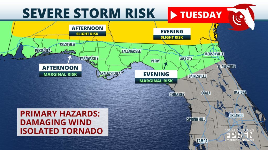
Locations north of the I-10 corridor and near the Alabama and Georgia borders have the greatest chance of a strong storm, where forecasters at the National Weather Service have designated the risk as “slight” (or level two out of five). Residents in the Florida Panhandle, Florida’s Big Bend and most of northeast Florida are under a “marginal” risk.
A storm system was developing over the Rockies Monday, and was joining forces with a warm front stretched across the Gulf Coast states. Clusters of severe storms are expected to form along and ahead of the front from Kansas to Mississippi Monday night, spreading east into portions of Alabama and Georgia Tuesday.
A weak cold front is also projected to sweep across the northern third of the Sunshine State Tuesday into Wednesday, and this will be the primary driver of the scattered thunderstorm activity as it relates to Florida.
The unsettled weather is first likely to arrive in the western sections of the panhandle, near cities like Pensacola and Crestview, Tuesday morning. It will then spread east toward cities like Panama City and Tallahassee in the afternoon hours, followed by areas of northeast Florida from Lake City to Jacksonville in the evening an overnight hours.
A few showers could develop ahead of the cold front in Central Florida Wednesday, but they are expected to stay weak and pose no severe risk. The cold front is projected to exit the state Wednesday night, and be followed by notably cooler and dry conditions through the end of the week.


