FPREN - Scientists say this year’s Atlantic hurricane season could be more active than normal, but stress the role uncertainty plays 60 days out.
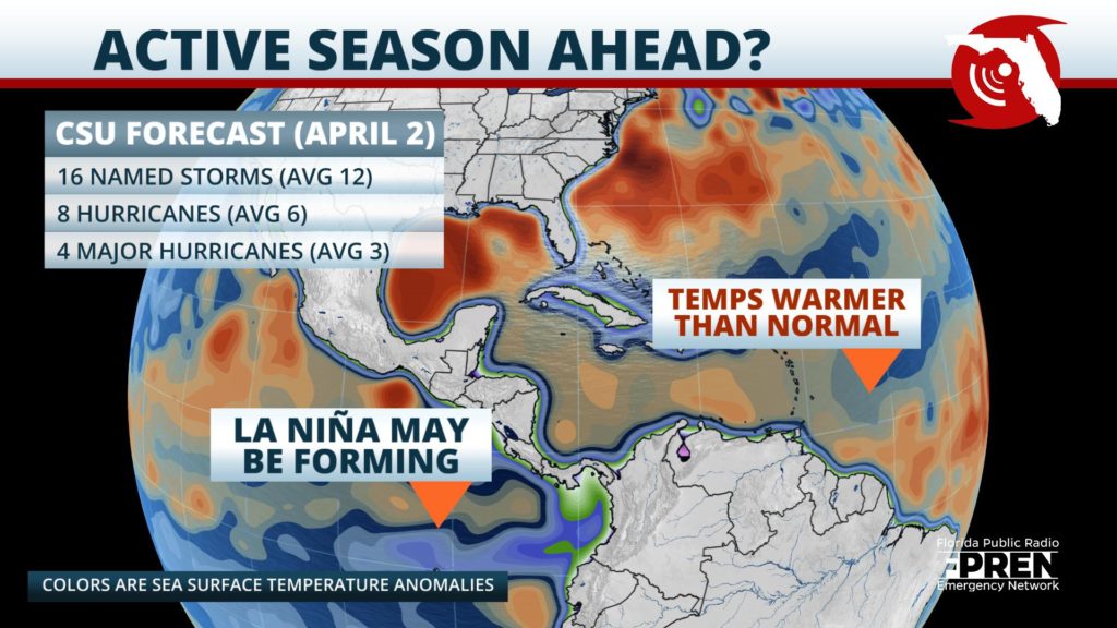
The Colorado State University (CSU) Tropical Meteorology Project team, led by Dr. Phil Klotzbach, is predicting 16 named storms, eight hurricanes, and four to reach major hurricane strength with winds 111 mph or greater. A normal season usually consists of 12 named storms, six hurricanes and three major hurricanes.

Phil’s team points to the increasing chances that a La Niña will develop in the Eastern Pacific this summer and the already above normal sea surface temperatures in the Central Atlantic as the primary reasons for their early projections. A La Niña event typically correlates to an increase in hurricane quantities in the Atlantic and a decrease in the Pacific.
CSU bases its forecasts on models that includes 38 years of historical data, such as sea surface temperatures, sea level pressure, upper-level winds, and oscillations in the relationship between these factors.
Klotzbach also pointed out on Twitter that one of the reasons for the above-average forecast is the lack of an El Niño that developed last fall, and that an El Nino “generally increases vertical wind shear in the Atlantic, tearing apart hurricanes.“
The researchers have also noted that the sea surface temperatures in the tropical Atlantic and the subtropical Atlantic are already above normal for this time of the year. Sea surface temperatures of at least 80 degrees Fahrenheit (26.5 Celsius) is a primary ingredient for tropical storm and hurricane formation.
Water temperatures in the Gulf of Mexico are also warm, running as high as two degrees above normal as of April 2.
During a teleconference chat with Dr. Klotzbach Thursday from the National Tropical Weather Conference, he emphasized there was less of a correlation to the anomalies in that body of water compared to the Atlantic overall
“Yes, the waters [there] are warm, but it’s really more about whether a disturbance can move into the Gulf this time of year, and at the same time if the wind shear is low enough.”
Klotzbach encourages residents to remain vigilant and be prepared before the official start of the hurricane season, which begins June 1st.
“It does not matter how many hurricanes are forecasted; it takes only one storm to put people in danger,” Klotzbach says.
A tropical or subtropical storm has formed outside the designated start date over the last five years consecutively. In the past decade, nine named system have formed outside of the June 1st start date.
Florida’s chances of a hurricane landfall this year are at 68%, which according to Klotzbach, is far more than any other state. This is an increase of 17% from an average of 51%. There is a 31% chance (average is 21%) that a major hurricane could directly impact the Sunshine State, which is a 10% increase from normal.
The CSU report also includes the probability of major hurricanes making landfall along all coastlines in the North Atlantic Basin.
The forecast team also tracks the likelihood of tropical storm-force, hurricane-force, and major hurricane-force winds occurring at specific locations along the coastal United States, the Caribbean and Central America through its Landfall Probability website.
This is the 37th year that the CSU hurricane research team has issued their Atlantic basin seasonal hurricane forecast. Bill Gray, the founder of the seasonal forecasts, launched the report in 1984 and continued to author them until his death in 2016.
Meteorologists from Accuweather, including top hurricane expert Dan Kottlowski, released their 2020 Atlantic hurricane forecast at the end of March, also calling for an ‘above-normal’ season.
Kottlowski’s team is calling for 14-18 tropical storms during the upcoming season. Seven to nine are forecast to become hurricanes, and two to four are predicted to strengthen into major hurricanes.
“There are a number of analog years we looked at that certainly show high-impact storms affecting the United States,” Kottlowski explained.
“These could be direct hits or a storm scrapping the coast but still causing impacts.”
The hurricane forecasts provided by each meteorological agency are intended to provide a best estimate of activity across the entire Tropical Atlantic Basin during the hurricane season. It is not a prediction on where a storm might track, how strong it could become, or when it might impact any given location.
There is no strong correlation between the number of hurricanes and landfalls in any given season. This is why coastal residents should prepare each year no matter the forecast.
The 1992 hurricane seasons is an example of why coastal residents need to be prepared regardless of the seasonal forecast. The season produced only six named storms and one subtropical storm. However, one of those storms was Hurricane Andrew, which devastated South Florida as a Category 5 hurricane and claimed 26 lives.
In contrast, the 2010 Atlantic hurricane season was considered active, with 19 named storms and 12 hurricanes. Despite the large quantity of storms that year, only one tropical storm made landfall in the United States.
The next credible hurricane forecast will be released by the National Oceanic and Atmospheric Administration (NOAA) in late May. CSU will release their next seasonal forecast on June 4, 2020.
