A Tornado Watch has been issued for all of Central Florida until 11 am EDT Friday morning, as a dangerous line of severe thunderstorms moves inland from the Gulf of Mexico.
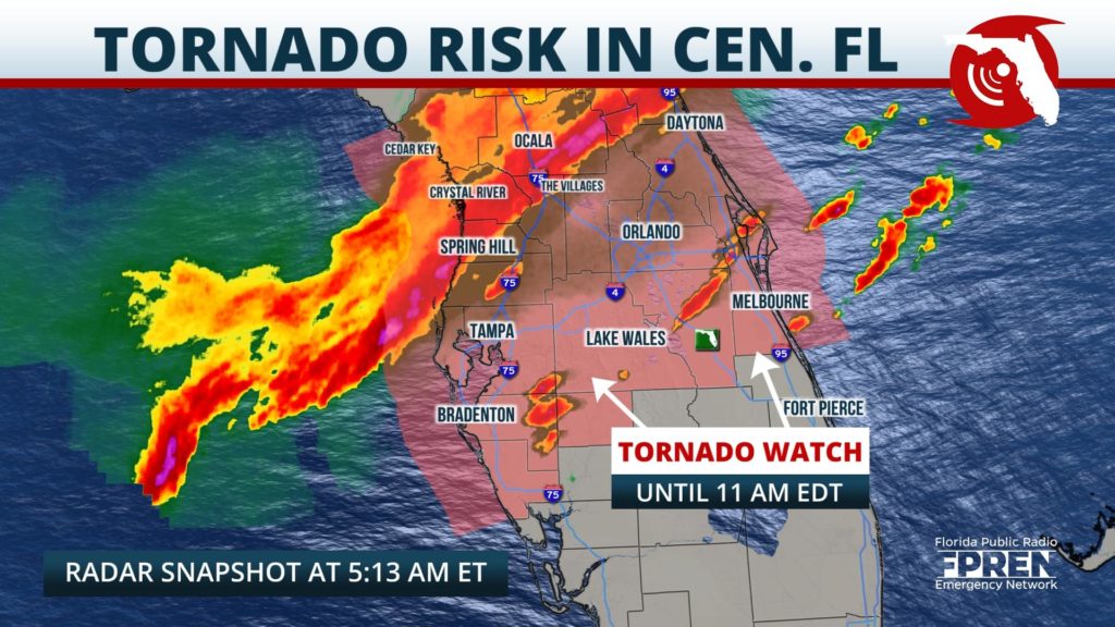
The watch includes the cities of Tampa, Lakeland, Ocala, Orlando, Daytona Beach, Melbourne and Sarasota. Damaging wind gusts up to 60 mph and embedded tornadoes are possible from the strongest cells, along with very heavy rain and frequent cloud-to-ground lightning.
As of 5:30 am EDT, the line of storms stretched from Daytona Beach to The Villages, then farther southwest toward Spring Hill and Clearwater. Thunderstorm cells embedded in this line were moving east at 40 mph, while the entire complex of rain and thunder was propagating southeast at a slightly slower pace.
The storms are on track to move through the Tampa and St. Petersburg metro areas between 6 and 7 am, then cross the I-4 corridor between Lakeland and Orlando between 7 and 8 am.
Forecasters and emergency operation officials recommend residents have multiple ways of receiving warnings, including via cell phone, radio, and television. Residents should be prepared to seek shelter in the lowest level of their home, in an interior room, and away from windows. Updates from the Florida Public Radio Emergency Network will be available on the Florida Storms mobile app and social media accounts.


