Recent track forecast improvements prevented millions of Floridians from unnecessarily evacuating ahead of Hurricane Dorian last year, but a new report also reveals record-setting errors in its intensity forecast.
Hurricane Dorian defied forecasts in multiple ways along its journey, but there were some meteorological success stories as well. The system’s track and intensity were not well forecast as it moved through the eastern Caribbean and southwest Atlantic. However, despite becoming the strongest hurricane in modern records to hit the northern Bahamas, most Floridians were spared significant harm and unnecessary evacuations, thanks to a projected northward turn that verified.

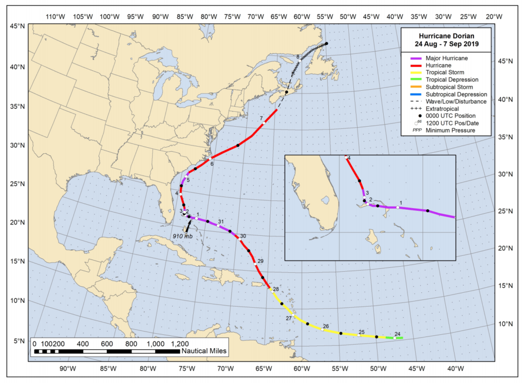
The report, which was released by the National Hurricane Center (NHC) April 27, details the life cycle of the historic hurricane; from its formation in the tropics, to its devastating impact on the Bahamian Islands, ending with its dissipation in the North Atlantic.
Dorian was a tropical storm when it passed through the Leeward Islands on Aug. 27, and its fate appeared to be largely tied to future interactions with the mountainous islands of Puerto Rico or Hispaniola. Instead, Dorian’s circulation remained to the right of the projected track and was largely unaffected by the smaller U.S. and British Virgin Islands. The storm was then able to quickly intensify into a hurricane, resulting in a “lack of adequate warning” for some of the islands, the report says.
Hurricane Dorian became a large and extremely dangerous Category 5 storm as it approached the northern Bahamas on Sept. 1. The storm was only 180 miles from Miami when winds peaked at 185 mph, yet no hurricane watches or warnings had been posted yet. It is historically uncommon for a westward moving hurricane in The Bahamas -- especially one that is potentially catastrophic -- to not require watches or warnings in South Florida.
“I don’t remember that happening in modern times,” says Brian Norcross, a hurricane specialist at Local 10 News in Miami says.
Norcross emphasizes that even with the slight forecast miss offshore of Florida and dramatic deviation in the Caribbean, the overall average track forecast errors for Dorian were quite low.
Dorian’s extremely slow forward speed, which at times was nearly stationary, allowed emergency managers enough time to make better decisions.
National Hurricane Center Storm Surge Specialist Jaime Rhome says recent improvements in storm surge forecasting and communication also gave officials better support to make critical decisions.
“We estimate that approximately 3 million evacuations were prevented, compared to historical evacuations during similar storms,” Jaime said during a recent presentation at the National Tropical Weather Conference. “This was based on an analysis conducted with the state and county emergency managers,” he added.
Beginning with the advisory issued at 11 a.m. EDT Aug. 31, forecasters at the National Hurricane Center started expressing confidence in a northward turn, sparing Florida a direct hit. If Dorian would have deviated from that track, there would have still been ample time to warn Floridians and call for evacuations. But it didn’t. However, out of an abundance of caution, hurricane and storm surge warnings were eventually issued for coastal locations from Palm Beach County to Ponte Vedra Beach since the storm’s wind field was likely to expand in size by the time it made the turn.
Despite the far better outcome for the United States, especially the state of Florida, the National Hurricane Center admits there were critical challenges with Dorian’s intensity, speed and track forecasts before it arrived in the Bahamas.
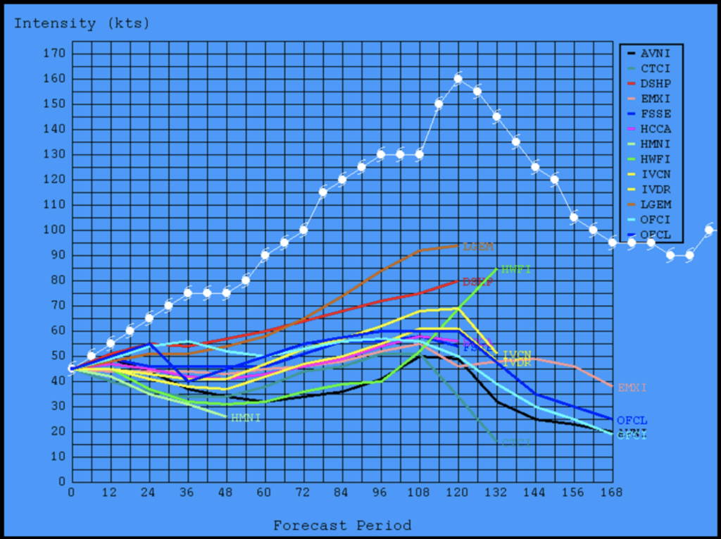
The most anomalous errors were related to rapid intensification. The report notes that “none of the intensity models were able to capture the intensity trend” five days prior to reaching its peak intensity in The Bahamas. In fact, NHC Branch Chief Michael Brennan says the errors were historic.
“Dorian had the three largest NHC 5-day intensity forecast errors since NHC began making public 5-day forecasts in 2003,” he said.

The overall track forecast for Dorian verified with far fewer errors than the running 5-year mean, the report states. However, a significant shift was necessary when the tropical storm’s center reformed farther north (to the right of its trajectory) after crossing St. Lucia. Dr. Brennan says this is why the intensity forecast errors were so large, because the center would not cross the more disruptive island of Hispaniola, which was the original forecast.
“This enabled Dorian to take full advantage of the very favorable atmospheric and oceanic conditions in the southwestern Atlantic as it approached the Bahamas,” he added.
Forecast models did indicate that Dorian’s forward speed would decrease upon approach to the Northern Bahamas, however, none of them indicated that Dorian, as a Category 5 hurricane, would stall over the islands.
Hurricane Dorian made landfall with maximum winds of 185 mph (298 km/h) in Elbow Cay on Grand Abaco September 1st. Dorian spent more than a day destroying the island, moving at less than 5 mph to the west before stalling over Grand Bahama the next morning. The lowest estimated barometric pressure reading was 910 mb, which ranks as fifth lowest at landfall and twelfth lowest overall in the Tropical Atlantic Basin.
Dorian weakened to a Category 2 storm as it made the much-anticipated turn to the north on Sept. 3, roughly 60 miles east of the Treasure Coast. It then paralleled the Southeast coast of the United States and made landfall in Cape Hatteras, North Carolina three days later. The storm accelerated to the northeast as it moved back over water and toward Nova Scotia, where it produced hurricane force wind gusts on September 7th. Dorian then dissipated over the North Atlantic on September 9th.
An estimated 200 people lost their lives in The Bahamas from Hurricane Dorian, according to the country’s health minister. However, it may never be known the true number of deaths from the violent storm. An estimated 75% of the homes on Great Abaco Island were damaged or destroyed, where Dorian produced at least tropical storm force winds (39 mph or greater) for three days straight.
Total damages in the Bahamas are estimated to be around $3.4 billion US dollars. Dorian left 29,000 people homeless and/or jobless, according to the Inter-American Development Bank. The effort to rebuild is now only beginning, and has recently been slowed due to the COVID 19 pandemic.
“For perspective, think about our friends on Abaco and Grand Bahama Islands and what they’re facing, when what we’re going through feels like too much,” Norcross says.
The 2020 Atlantic Hurricane Season will begin June 1, and many reputable forecasters believe it will be an active season overall. The National Hurricane Center and Federal Alliance for Safe Homes have launched preparedness campaigns to help residents in hurricane prone areas get ready. The Florida Public Radio Emergency Network will be sharing those ideas to help you and your family prepare for the season ahead in the coming weeks.
