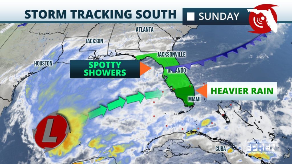
Beneficial rain is still in the forecast in South Florida Sunday and Sunday night, where some of it could be heavy. However, lesser amounts are now expected across the rest of the peninsula, thanks to a southward shift in the projected path of an approaching storm system from the Gulf of Mexico.

Showers are first expected to develop across portions of North Florida Saturday night, behind a slow-moving front. Cities such as Gainesville, Jacksonville, Ocala, and St. Augustine will likely wake up to some wet weather early Sunday. In these areas, only spotty rain showers are then expected during the day on Sunday, and even those may completely dry up by late afternoon.
It isn’t until midday Sunday, when a disturbance develops along the southward sagging front, that the heaviest rain is expected to fall across Central Florida. Downpours will likely develop over cities such as Tampa, Orlando, and Melbourne by Sunday afternoon, then across much of South Florida from Fort Myers to Miami by Sunday evening. A few strong thunderstorms with gusty winds are also possible across the Florida Keys Sunday night.
The rain event will be rather brief in most spots north of The Everglades, lasting only a few hours before quickly exiting to the east. However, locations along and south of I-75 in Collier, Monroe, and Miami-Dade counties may see several more hours of heavy rain Sunday night. This is due to more instability and moisture being present closer to where the storm system tracks, which is most likely to be across the Florida Straits early Monday.

Rainfall accumulations will likely be less than inch in most of north and central Florida, but could be as high as two inches in the aforementioned areas of South Florida near and south of I-75. Locally higher rainfall amounts will be possible, especially in areas that receive multiple rounds of showers and thunderstorms. This appears most likely across the Florida Keys and in southern portions of Miami-Dade County.
Sunday and Monday’s rain will alleviate some of the drought conditions that have developed over much of the Sunshine State, especially across Southwest Florida where the largest rainfall deficits have been this year. The storm system should exit Florida’s Atlantic coast before sunrise on Monday, with drier air presiding across the state through midweek.
