Skies over the Caribbean have become filled with dust, as the thickest Saharan Air Layer (SAL) in over half a century continues to march west from massive dust storms in West Africa.
The haze will begin to fill the skies in parts of the Florida Panhandle Thursday, then spread across the rest of the state through the weekend.
The dust layer is so large that astronauts stationed at the International Space Station were able to capture images of the dense plume as it approached Puerto Rico and portions of the Dominican Republic Sunday.
“Amazing how large an area it covers!” wrote astronaut Col. Doug Hurley on Twitter, who recently launched from Florida’s Cape Canaveral.
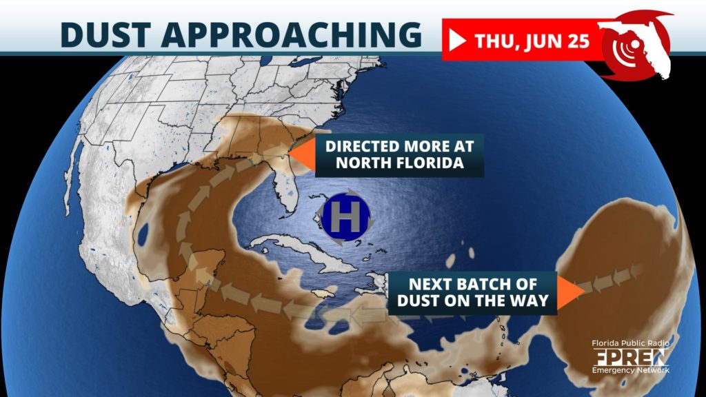
Residents of the Florida Panhandle will likely notice the dust first Thursday, whereas much of South Florida may not see it until the weekend. This is a bit backwards from a typical event, and largely attributed to the wind pattern around a strong high pressure system parked near The Bahamas.
The core of the SAL plume has stayed south of Florida so far, as easterly winds around the high pushed it westward into the southern Gulf of Mexico. The dust will begin to turn north Thursday, moving around the western side of the high pressure system and approach the northern Gulf Coast states of Louisiana, Mississippi and Alabama. This is when it will also become apparent in the skies over the Florida Panhandle.
The highest concentrations of SAL will remain across the northern third of the state through Friday, before it gradually sags south into portions of Central Florida this weekend. Much of South Florida will likely not see significant effects from the dusty air until at least Sunday, and even then there is uncertainty to what extent it will remain in the atmosphere.
Hazy skies, lower rain chances, and hotter temperatures are the typical meteorological effects from the Saharan air when it arrives in Florida. This event is particularly strong, and it could also lead to unhealthy air quality for those with sensitive respiratory conditions.
This dusty air creates a very dry environment, with the highest concentrations of particles found about 10,000 to 20,000 feet in the atmosphere. This usually prevents thunderstorms from developing or lasting very long, and will drastically lower rain chances for a few days in most areas. However, if a thunderstorm can form and survive in this type of environment, it could produce strong winds due to the cooling effect of evaporating rain as it falls.
Although rain is unlikely with SAL overhead or nearby, the air closer to the surface of the Earth can still become oppressively hot and humid, leading to dangerous heat index values or “feels like” temperatures. This is expected to occur across portions of west-central Florida Thursday.
One benefit to the SAL is the picture-perfect sunrises and sunsets it could produce.
“Solar light scatters off the dust particles in the atmosphere which display red and orange colors on the visible light spectrum”, Meteorologist Tim Sedlock from the National Weather Service in Melbourne explained to the Gadsden Times.
However, there is a fine balance with how much dust can be in the atmosphere before the vivid oranges and reds disappear and the sky becomes hazy and brown. A light dust layer, which is expected across the Florida Panhandle Thursday, will create the perfect setting for the bright reds and oranges, provided the sky is relatively free from cloud cover at sunset or sunrise.
Another silver lining to this extremely dry environment is that it inhibits tropical cyclone activity. The dust depletes deep moisture which tropical systems need to from and strengthen. Therefore, large scale weather systems, such as hurricanes, usually do not form in these dry environments.
The SAL plume, which is over 2,000 miles wide, was lofted into the air by large thunderstorm complexes a week ago over the dry deserts of West Africa.
“Traveling dust plumes typically occur between the spring and fall months, according to David Wally, a meteorologist with the National Weather Service office in Upton, New York.
Intense winds from the thunderstorms blow dust from the Saharan Desert out over the eastern Atlantic Ocean. These fine particles of dust, sand and dirt are then transported thousands of miles to the west by the trade winds.
”Dust layers often reach the Caribbean islands, but will sometimes make it as far west as the United States,“ David added.
So how exactly does dust create those beautiful colors? The process begins with sunlight traveling to the Earth which contain different colors, each of which have a different wavelength. The shortest wavelength color is blue, which is absorbed by air molecules and scattered across the sky when the sun is high in the sky.
As the sun sets, creating a smaller angle upon the surface, the light must travel through more of Earth’s atmosphere. This allows longer wavelength colors to be visible to the naked eye, such as oranges, pinks and reds. When Saharan dust is present in the atmosphere, the colors of the sunset are enhanced to look deeper and darker in color due to the tiny dust particle scattering more of the sunlight across the sky.
This week’s air quality fell to hazardous levels across the Caribbean from the dust, and experts are reporting that they have not seen this density of dust in half a century.
“This is the most significant event in the past 50 years,” said Pablo Méndez Lázaro, an environmental health specialist at the University of Puerto Rico. “Conditions are dangerous in many Caribbean islands.”
Lázaro commented that the concentrations of dust and dirt in the atmosphere was so high that he was concerned it could have adverse effects on healthy individuals.
Limited visibility and extremely hazy conditions were reported across the Lesser and Greater Antilles where the event is expected to last through Tuesday.
The National Weather Service in San Juan, Puerto Rico said visibility had been reduced across the island down to only five miles Monday as the region was engulfed in a thick layer of haze and dust.Too much dust can also be a hazard under water, long after it disperses from the atmosphere.
John Walsh and Karen Steidinger studied the effects of Saharan dust and the red tides being produced along Florida’s Gulf coast. Saharan dust delivers nutrients, particularly iron, into the Gulf of Mexico. When the dust descends onto the waters of the Gulf it attracts a cyanobacteria, known as Trichodemium which uses the iron to convert any nitrogen in the water to form a food-like substance that can be consumed by other marine organisms, including algae that produces the red tide.
Respiratory problems may also pose problems to those in the path of the Saharan dust plume but Sedlock says Floridians should not be concerned and will pose little threat to their respiratory health.
"Maybe in the Caribbean islands, but it's not generally expected to have any effects for respiratory issues across Florida," Sedlock said.
However, health officials are still warning those with underlying lung conditions to avoid outdoor activities and wear masks with air filters, the New York Times reports.
Dr. Sandro Galea, dean of the Boston University School of Public Health still suggested that people monitor the “level of air particles in their area and take precautions in working or being outside as this passes through.”
Dr. Len Horovitz, a pulmonary specialist at Lenox Hill Hospital in New York City, also said on Monday that “particulate matter of this dust cloud contains more silica, and is a hazard to those with underlying lung conditions. But even normal healthy people are subject to irritant effects.”
Horovitz recommends wearing masks and using air filters, as well as avoiding outdoor activities for those with respiratory problems.
Dry and dusty skies will linger across portions of the state through at least the weekend and possibly into early next week, keeping shower chances unusually low but not completely diminishing them. Hot temperatures with high heat index values ranging from 100 to possibly 110 are likely to continue into the weekend. Once the dust clears, moisture will be able to ascend back into higher layers of the atmosphere, leading to higher rain chances and lower heat index values by Monday or Tuesday.


