Showers and thunderstorms will likely become more numerous across the Sunshine State over the next several days, potentially putting a damper on some holiday weekend plans.
An uptick in afternoon thunderstorm chances are expected in most locations, and portions of Central and North Florida may see heavier and longer lasting episodes of rain Saturday and Sunday.
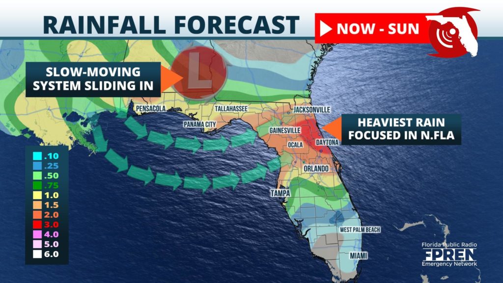
On Wednesday, the Saharan dust plume, which was first introduced into the Florida Panhandle last Thursday, was observed to be moving away from Florida. At the same time, a potent trough in the mid-levels of the atmosphere was dipping into the Mid Atlantic from the Northeast, while a cold front at the surface was sagging into the Southeast. The circulation around these two features will draw in rich Gulf of Mexico moisture across the northern half of Florida.
The unsettled pattern is expected to remain in place over the Southeast through the holiday weekend, enhancing the diurnal sea breeze thunderstorms across the northern two-thirds of the state each afternoon. Periods of rain might also develop in the overnight and early morning hours near the Gulf Coast from the disturbance.
This is welcome news for residents in west-central Florida, where rainfall has been well below normal since mid-June. Three-day rainfall totals from the Nature Coast to the First Coast, stretching as far south as the I-4 corridor near Orlando, are expected to be in the one to three-inch range. Locally higher amounts will be possible where multiple downpours occur. Lesser rainfall amounts of around an inch are possible across surrounding areas of the Florida Panhandle and Northeast Florida.
Central and South Floridians are not expected to receive an abundant amount of moisture from the storm system, therefore rainfall chances and amounts are likely to be closer to normal for this time of year in cities such as Fort Myers and Miami.
Temperatures will cool down a bit in the areas that experience the most widespread rain and cloud cover. However, much of South Florida is likely to continue baking in well-above normal temperatures through at least Sunday where rain chances will be lower.


