A tropical storm or hurricane is not expected to threaten Florida this weekend. However, an abundance of tropical moisture from a nearby tropical wave could lead to repeating downpours and possible flooding in portions of the state.

The National Weather Service issued a Flood Watch Thursday afternoon for all counties along Florida's Gulf Coast from Tampa to Fort Myers, where meteorologists say current forecast data suggests enough rain may fall on already saturated ground to cause flooding. A tropical wave is expected to traverse the state Saturday, further enhancing some of the rainfall, thus the watch is in effect through Sunday morning.
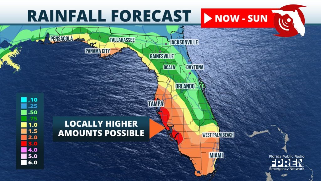
Rainfall amounts through Sunday are likely to range from 2 to 4 inches along and west of I-75 from Tampa to Naples, with locally higher amounts possible in some areas. Generally, 1 to 3 inches of rain is expected over the three-day period across the western half of the peninsula and along coastal sections of the Florida Panhandle. Lesser amounts of rain are expected along Florida's Atlantic Coast, except for portions of South Florida where amounts up to 2 inches will be possible.
Elsewhere in the tropics, there are multiple areas being monitored for possible future development in the next five days. However, none of them are an immediate threat to the Sunshine State. Tropical storms Paulette and Rene also continue to spin across the central Atlantic, but are not likely to affect any land areas of North America.
The next tropical storm of the 2020 Atlantic Hurricane Season would be named “Sally”. The current record for earliest “S” named storm belongs to Stan which formed on October 2, 2005. There have already been an impressive fourteen records for earliest named storms this year in the tropical Atlantic basin.


