Days of heavy rain may lead to historic flooding over parts of the central Gulf coast, including the western Florida Panhandle.
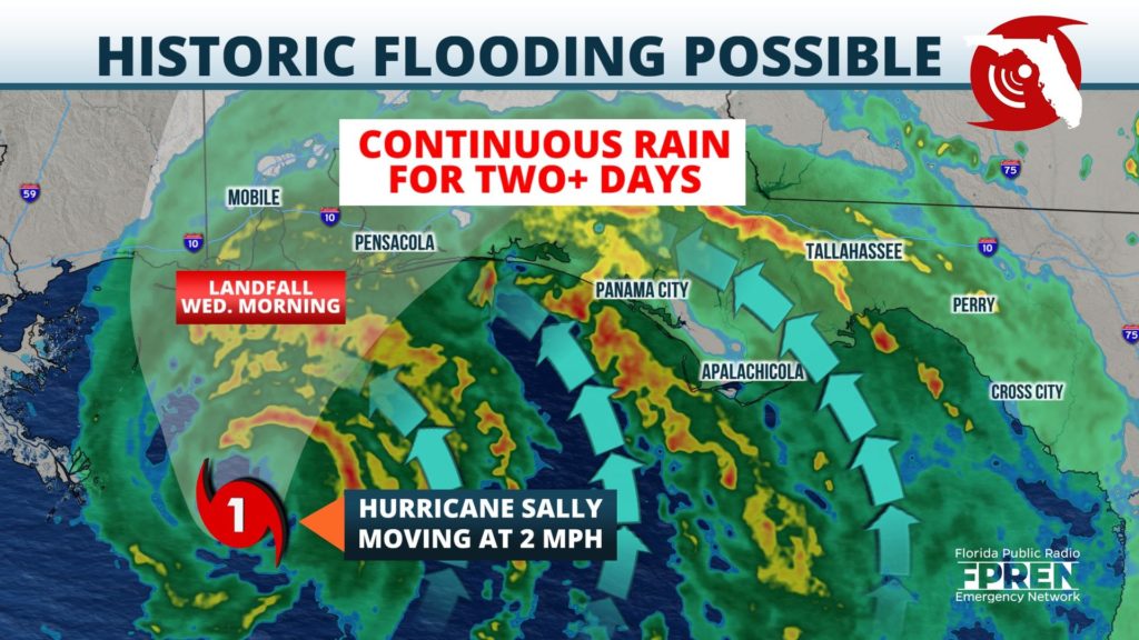
The National Hurricane Center said extreme life-threatening flash flooding is likely through Wednesday in their early morning advisory. As of the its midday update Tuesday, maximum sustained winds were near 85 mph. It is moving slowly toward the northwest at 2 mph.
Rain bands from the storm are already onshore. The strongest bands were a few miles offshore and are expected to move inland Tuesday afternoon through Wednesday. Coastal Hurricane Warnings are in effect from Navarre westward. Coastal Tropical Storm Warnings were in effect east of Navarre to just west of St George Island. Hurricane Warnings were also in effect inland for Escambia and Santa Rosa counties, and a Tropical Storm Warning was in effect for inland Okaloosa county.
Sally is forecast to make landfall on Wednesday as a category 1 hurricane between Biloxi and Pensacola, but Sally’s slow movement means water, not wind, will be the primary hazard from the storm.
Storm Surge Warnings are in effect from the Okaloosa/Walton county line and westward. The official forecast from the National Hurricane Center is projecting surge of 2 to 4 feet of water above normally dry ground, particularly in northern Escambia Bay near the Escambia and White Rivers; in Blackwater Bay near the Yellow and Weaver Rivers; and near the Blackwater River in Santa Rosa county. Other areas of surge are likely along the barrier islands in places from Perdido Key to Pensacola Beach to Santa Rosa and Okaloosa islands. Peak surges of 1 to 3 feet are possible eastward toward Panama City, Apalachee Bay, and the Big Bend coastline. High surf and dangerous rip currents are expected to pose a danger to swimmers, as well.
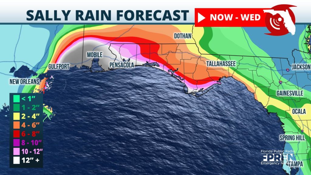
Rainfall amounts of 10 to 20 inches are anticipated in Escambia, Oklaoosa, and Santa Rosa counties, with isolated amounts up to 30 inches possible. These amounts were expected to lead to widespread and potentially historic flash flooding in some areas, forecasters said. Amounts of 5 to 10 inches are possible for the Panama City to Marianna areas. The Tallahassee to Apalachicola area was expecting 2 to 5 inches of rain through Thursday. Flash Flood Watches are in effect for much of the panhandle.
NOAA’s Storm Prediction Center said a couple of tornadoes may occur Tuesday and Wednesday over the Florida Panhandle associated with Sally’s rainbands. The center issued a Tornado Watch, mainly for the Apalachicola River and westward until 6 PM Tuesday. Oftentimes, tornado watches are extended in slow-moving storms like Sally when the tornado threat is likely to continue past the expiration time.
Sally is expected to merge with a cold front and move off the Carolina coast on Friday. Slightly drier air is likely over the Panhandle this weekend, but the cold front may produce areas of rain over the Florida peninsula this weekend even after Sally’s departure.


