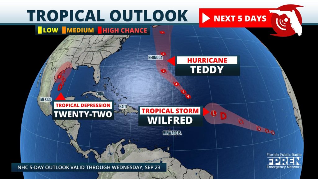
Two new tropical storms and a new tropical depression have formed in the past 24 hours, joining Major Hurricane Teddy in an already historic hurricane season.
Hurricane Teddy is the strongest of the current storms, a Category 4 hurricane, and is located over the open waters of the Central Atlantic. It is forecast to track northwestward this weekend before being deflected due north by a frontal system exiting the United States. Teddy is expected to near Bermuda early next week, and could deliver another round of heavy rain and storm surge to the island that was impacted by Category 1 Hurricane Paulette on September 14. Forecasters at the National Hurricane Center say that Teddy could still be a hurricane toward the middle of next week as it approaches Nova Scotia.
NO CURRENT STORMS IN ATLANTIC BASIN
Tropical Storm Wilfred, the last storm name from the Latin alphabet, formed in the eastern Atlantic on Friday morning. Wilfred will likely not exhibit too much additional strengthening as moves westward over the weekend. By early next week, forecasters at the National Hurricane Center say that Wilfred will likely degenerate into a remnant low.
Tropical Storm Wilfred, the last storm name from the Latin alphabet, formed in the eastern Atlantic on Friday morning. Wilfred will likely not exhibit much additional strengthening as moves westward this the weekend. By early next week, forecasters at the National Hurricane Center say that Wilfred will likely degenerate into a remnant low.
Tropical Depression Twenty-Two has the nearest proximity to the United States: On Friday morning it was located over the western Gulf of Mexico, about 250 miles southeast of the Texas and Mexico border. This system has exhibited signs of organization, and forecasters expect it to strengthen into a tropical storm late Friday or early Saturday. Once this occurs, it will acquire a name Beta.
NO CURRENT STORMS IN ATLANTIC BASIN
Subtropical Storm Alpha also formed on Friday and was located off the coast of Portugal during the early afternoon. This marks the first time since 2005, and only the second time in history, that the Greek alphabet has been employed to name storms. Alpha will likely be a short-lived system, but is expected to douse Portugal with heavy rain and create rough seas.
Regardless of when or if Tropical Depression Twenty-Two intensifies, the system is expected to remain over the western Gulf of Mexico through at least the middle of next week. After that, remnant moisture and energy from the system could track toward the Central or Eastern Gulf Coast, including Florida's Gulf Coast. Should this occur, rain chances will likely increase and dangerous surf could develop at the beaches. Interests in these areas should follow the forecast closely in the coming week.