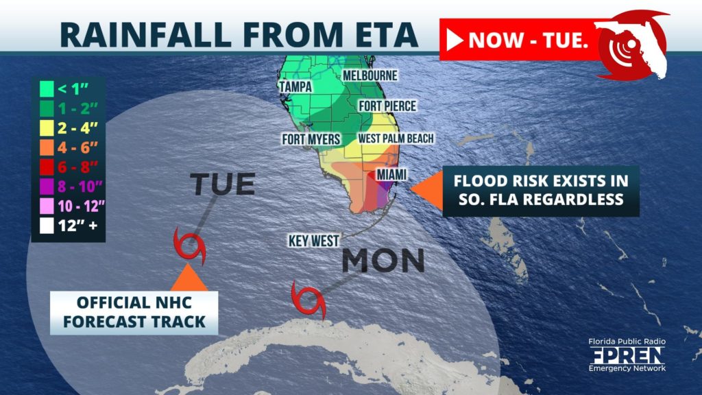
Days of heavy rainfall may increase the risk of flooding over saturated South Florida this weekend, ahead of what is likely to be the approach of Tropical Storm Eta from the Caribbean.
Eta made landfall as a powerful category 4 hurricane Tuesday in Nicaragua, but weakened to a tropical depression Wednesday night over Central America. Forecasters at the National Hurricane Center said it's possible there is no longer a low-level circulation because of its continued interaction with higher terrain. Its remnant circulation is forecast to move back over warm waters of the northwest Caribbean Sea on Friday, where atmospheric conditions make restrengthening into a tropical storm a possibility.
The latest Hurricane Center forecast track takes the center of the Eta near or over Cuba on Sunday, but heavy rain is expected to arrive well in advance of Eta. Persistent easterly winds were already causing showers to affect South Florida Thursday and the rain is forecast to increase in areal coverage and intensity as the influence from Eta increases over the weekend.

The forecast path of Eta is more uncertain than usual which will alter rainfall amounts, but around a foot of rain is possible in Southeast Florida starting Friday and lasting through the mid next week. Rainfall amounts of 3 to 6 inches are possible as far north as the Space and Treasure coasts and extending westward through the Florida Heartland into Southwest Florida. Over the past 30 days, data from rain gauges and radar indicate parts of Miami-Dade, Broward, and Palm Beach counties have experienced 200 to 300 percent of their average rainfall. Meanwhile, the Treasure Coast has had about 150 percentage of its average during that time. Flooding is possible anywhere over South Florida, but these areas are particularly vulnerable because of the wet conditions so far this fall season.
Eta's effects are likely to last well into next week. The forecast cone has the center of Eta anywhere between the northwest Bahamas and the southeast Gulf of Mexico. A few computer model simulations are suggesting a broader range of possibilities, including a turn back toward the central Gulf. Forecasters encourage everyone in Florida to continue to carefully monitor the forecast for changes because of the low predictability of Eta and its potential impacts across different parts of the state.
