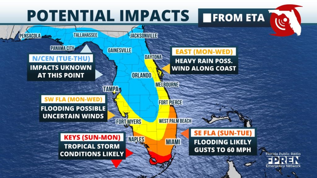
Days of occasional heavy rainfall may increase the risk of flooding over saturated South Florida late this upcoming weekend into early next week ahead of what is likely to be Tropical Storm Eta in the Caribbean. Tropical storm conditions are also possible along both the Atlantic and Gulf coasts as forecast trends bring the center of storm closer to the peninsula.

Eta weakened to a depression over Central America, but has since moved back over the warm water of the northwest Caribbean Sea. Atmospheric conditions make re-strengthening into a tropical storm a good possibility later Friday or Saturday.
The latest Hurricane Center forecast track takes the center of the Eta near or over Cuba on Sunday, but heavy rain is expected to arrive well in advance of Eta. Persistent easterly winds will likely causing showers to affect South Florida Friday and the rain is forecast to increase in areal coverage and intensity as the influence from Eta increases, especially Saturday evening into Sunday.
The forecast path of Eta is more uncertain than usual which will alter rainfall amounts, but 6 to 10 inches of rain is possible in Southeast Florida starting Friday and lasting through the middle of next week. Rainfall amounts of 3 to 6 inches are possible as far north as the Space and Treasure coasts and extending westward through the Florida Heartland into Southwest Florida. Over the past 30 days, data from rain gauges and radar indicate parts of Miami-Dade, Broward, and Palm Beach counties have experienced 200 to 300 percent of their average rainfall. Meanwhile, the Treasure Coast has had about 150 percent of its average during that time. Flooding is possible anywhere over South Florida, but these areas are particularly vulnerable because of the wet conditions so far this fall season.
Eta's effects are likely to last well into next week. The forecast cone brings the center of the storm into the Gulf of Mexico or near southwest Florida on Monday and Tuesday. Regardless of the exact track, periods of heavy rain and flash flooding are a possibility over much of the state, but it is difficult to say exactly where conditions may be the worst. Forecasters encourage everyone in Florida to continue to carefully monitor the forecast for changes because of the low predictability of Eta and its potential impacts across different parts of the state.
