Tropical Storm Eta officially made landfall at 4am Thursday morning near Cedar Key, Florida. The center of Eta officially exited the state near Jacksonville by early afternoon.
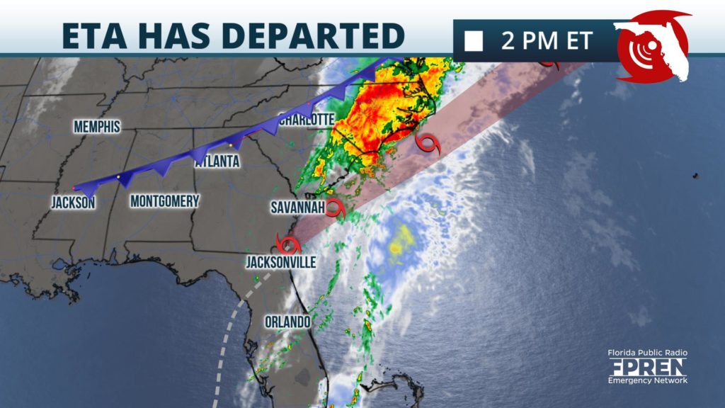
Dry air in the upper atmosphere and strong wind shear caused the storm to weaken before it made landfall on the Nature Coast. Occasional downpours and wind gusts to around 40 mph are still possible along the I-4 corridor through early Thursday evening due to a trailing trough of low pressure left by the storm. Since most of the rain and strong winds were ahead of the storm, conditions have been improving rapidly behind the storm from west to east across the peninsula.
Widespread wind gusts between 50 and 60 mph were observed from Sarasota and Manatee counties northward into the Tampa/St. Pete metropolitan areas Wednesday afternoon and evening. Wind gusts as high as 66 mph were reported near Beverly Hills in Citrus county from a private weather station. Gusts to near 50 mph were reported in Cedar Key and tropical storm force gusts in excess of 40 mph were recorded officially in Gainesville before sunrise Thursday. Tropical storm force gusts extended south into the Fort Myers area Wednesday afternoon when Eta was at its closest approach to Southwest Florida.
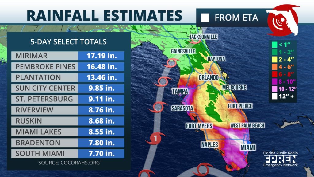
Official observing sites and radar estimations suggest more than a foot of rain fell in portions of Miami-Dade and Broward counties over the past five days, with much of that occurring Sunday and Monday. Numerous reports of flash flooding were received by local officials in and around the communities of Miami Lakes, Pembroke Pines, Davie and Fort Lauderdale. Flash flooding from an estimated 4 to 8 inches of rain also occurred southeast of Eta's second landfall in west-central Florida Wednesday and Wednesday night.
The National Weather Service passed along reports of storm surge flooding in Sarasota county near Longboat Key, which required the evacuation of some 50 to 100 people there. Additional surge flooding was reported between several inches deep and waist-deep in Pinellas, Hillsborough, and Pasco counties based on National Weather Service reports. Many of these reports occurred within a few hours of midnight, when high tide was expected along the west coast.
Drier conditions are anticipated across most of the state on Friday, except for a few remaining downpours across parts of water-logged South Florida.
Elsewhere in the tropics, a new tropical storm is likely to form in the eastern Caribbean within the next day or two. If it does, it would be the 30th tropical cyclone of the 2020 Atlantic Hurricane Season, which adds to the record that was previously broken with Subtropical Storm Theta in the north-east Atlantic. The previous record of 28 storms was set in 2005.


