A slow-moving cold front could produce numerous rounds of thunderstorms across parts of the Sunshine State to ring in the New Year.
On Thursday, a low pressure system lifting from Mexico into the Gulf Coast of Texas was intensifying into a winter storm as it moved northeastward into the Tennessee and Ohio Valleys. A cold front associated with the storm is expected to approach the western Florida Panhandle by Thursday night, just in time to ring in the New Year.
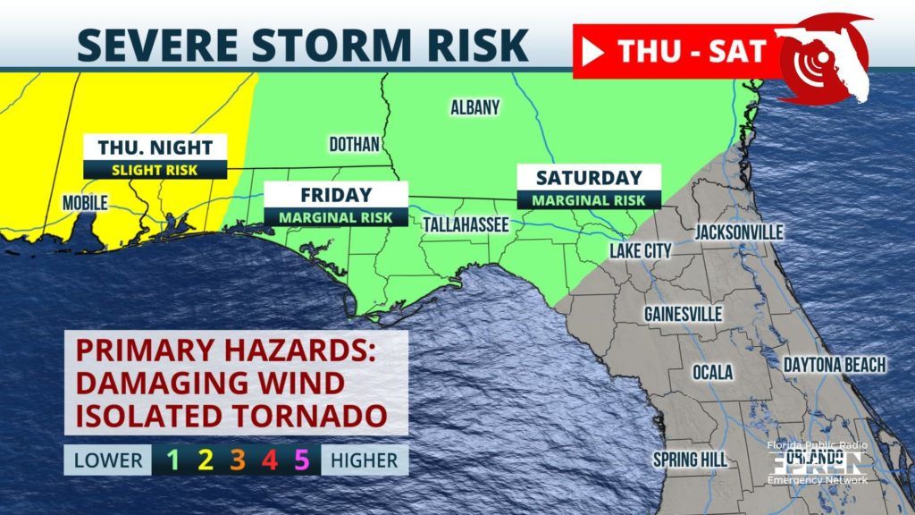
The Storm Prediction Center has issued a slight risk (risk level 2 out of 5) for portions of the far western Panhandle for Thursday and overnight into Friday. This risk area encompasses the cities of Pensacola and Destin. Strong storms are possible during the overnight hours Thursday, some of which may deliver heavy rainfall, potentially damaging wind gusts, and the chance for isolated tornadoes.
The low pressure system will continue northeast into the Great Lakes region Friday and into Saturday but the cold front, which will continue to extend down into the Central Gulf of Mexico, will make very little progress on its journey eastward. The front is expected to move through the western Florida Panhandle early New Year’s Day before slowly inching towards northern parts of the Peninsula late Friday night and into Saturday. A marginal threat (risk level 1 out of 5) is in place for Friday for the Apalachicola region and the Big Bend for the chance of heavy rainfall and strong straight-line winds. This threat extends eastward to encompass North Florida overnight into Saturday morning.
The cold front is expected to continue southeast crossing through Central Florida Sunday morning before moving into the Atlantic and away from the Sunshine State overnight into Monday. Near seasonal temperatures and drier conditions will return state-wide upon the passage of the front.


