Wind damage, hail, and even a few tornadoes are possible in portions of north and central Florida Saturday night ahead of a strong cold front approaching the Sunshine State. A few strong thunderstorms are also possible in South Florida Saturday afternoon, then again Sunday morning from the same storm system.
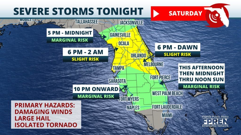
Forecasters at the Storm Prediction Center have identified a region roughly between Gainesville and Melbourne, stretching from the Gulf Coast to the Atlantic Coast, as having a "slight risk" (level 2 out of 5) for severe thunderstorms Saturday evening and overnight. This risk level includes the metro areas of Tampa, Orlando, Ocala and Daytona Beach as well. A "marginal" (level 1 out of 5) risk has been drawn to include locations farther south, such as Fort Myers and West Palm Beach.
Multiple rounds of thunderstorms are possible across Florida ahead of the approaching front through Sunday morning. A few cells could develop along a retreating warm front across portions of east-central Florida (near Orlando, Melbourne and Fort Pierce) in the afternoon and early evening hours Saturday. Small hail or damaging wind gusts are possible with the strongest storms with this round.
The more widespread thunderstorm activity is expected to develop along the approaching front near the Nature Coast Saturday evening. Clusters of strong storms capable of damaging winds, small hail, or even an isolated tornado are then expected to move across the peninsula, impacting the following communities at the most likely times listed below:
Scattered showers and thunderstorms are expected to continue progressing into South Florida during the morning and midday hours Sunday. Although these storms may not be as strong, gusty winds and heavy rain are possible in some areas before they weaken or dissipate entirely Sunday afternoon.
Floridians in the path of the strong storms tonight are encouraged to have multiple ways of staying informed. The Florida Storms mobile app is a free service of the Florida Public Radio Emergency Network and reliable resource for storm alerts for your location.


