The month of February has been very wet for much of the Sunshine State. Parts of North Florida and the Florida Panhandle have seen double the average of rain generally experienced during the the second month of the year. However, drier conditions are finally on the way once a cold front tracks through the state beginning Monday morning.
University of Florida student forecaster Anthony Bordanaro posted a map on Twitter Saturday from the Climate Prediction Center, highlighting the above normal rainfall that has fallen across the northern half of Florida recently.
A low pressure system over the central United States was continuing to move eastward Sunday into the Mississippi River Valley. Ahead of the cold front winds will shift to become more southerly across Florida, increasing atmospheric moisture and surface temperatures. Afternoon high temperatures could rise slightly above average for some locations. Mid to upper 60s are expected for the Florida Panhandle with mid to upper 70s across the Peninsula. A few areas could enter into the lower 80s Monday afternoon ahead of the cold front.
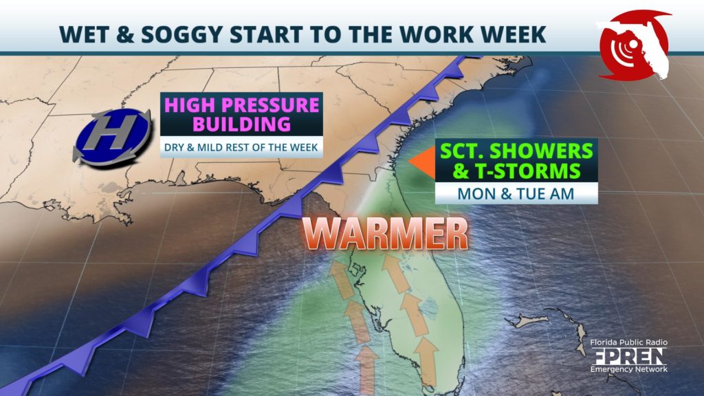
The cold front, by day break Monday, should extend from the low pressure system near the Great Lakes southwestward across the lower Mississippi Valley and into the northwest Gulf of Mexico. Scattered showers will begin first along western portions of the Florida Panhandle Monday morning before spreading eastward into the northern Peninsula in the afternoon and evening. Moderate atmospheric forcing is anticipated which will allow for widespread showers to develop ahead of the frontal boundary. Fortunately, upper level wind shear is expected to remain minimal and be confined offshore in the Gulf of Mexico. This should keep the severe risk minimal across Florida throughout the event, although an isolated strong to severe thunderstorm cannot be ruled out.
The heaviest rainfall is expected across portions of the Big Bend and north and central parts of the Peninsula as a prefrontal trough ahead of the cold front develops over the northeastern Gulf of Mexico and encompassed a large portion of the Florida Peninsula by the early evening. Waves of low pressure energy are expected to develop along the prefrontal trough, especially where it intersects the advancing cold front. Although thunderstorm activity will be minimal the threat for isolated flooding will remain for Monday afternoon and overnight into Tuesday.
The cold front will continue southeastward through Central Florida late Monday night and begin to move into South Florida early Tuesday morning before exiting into the Atlantic. Tuesday will mark the first day of what could be several days of dry and mild conditions across Florida as a surface high pressure system builds in from the west. Temperatures on the backside of the cold front will be cooler, dipping slightly below average, before rising back to near-average Wednesday.


