Severe thunderstorms capable of producing strong tornadoes, large hail and damaging winds are becoming increasingly probably over a large area of the Deep South Wednesday, and a few of these storms may affect portions of the Florida Panhandle.
A strong low pressure area over central California Monday morning is expected to move eastward toward the lower and middle Mississippi River Valley by Wednesday. Warm, humid, and unstable air -- the fuel needed for thunderstorms -- will be in place over large portions of Mississippi, Alabama, Georgia, and neighboring states. Strong wind shear, which is an increase in wind speed or direction as one goes up in the atmosphere, is forecast to be in about the same location as the unstable air. The end result is an increasing risk for dangerous severe storms as soon as Wednesday afternoon, lasting into Thursday.
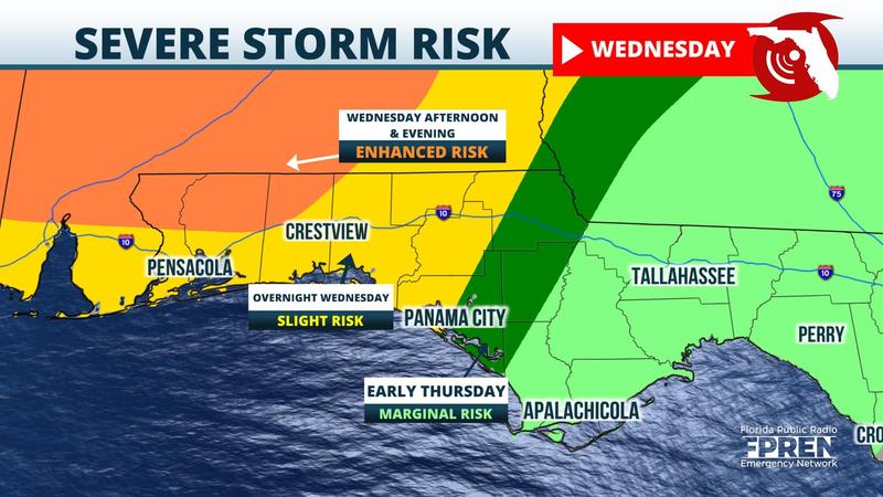
The Florida Panhandle will also have a risk for severe weather, but it may be somewhat less than areas farther north in Mississippi, Alabama, and Georgia. The start time of the greatest risk is subject to change, but the greatest potential appears to be from Wednesday afternoon until about dawn Thursday from Panama City and Marianna west to the Crestview, Destin, Fort Walton Beach, and Pensacola areas. If severe weather occurs in the Tallahassee and Big Bend areas, it would most likely happen after sunrise Thursday morning until about midday. Other parts of North Florida, including Lake City, Gainesville, and Jacksonville, could see strong storms Thursday afternoon. It is unclear at this time how widespread the severe weather could be Thursday afternoon since the greatest energy associated with the storm is more likely over Georgia and the Carolinas.
Everyone over North Florida and the Panhandle is encouraged to check in on the forecast in the coming days, especially on Wednesday and Thursday when tornado watches and severe weather warnings could be issued. Now is a good time to review or develop your severe weather and tornado safety plans in case protective action is needed later this week.


