An active weather pattern is possible for parts of the Sunshine State this weekend as a strong cold front moves in from the west.
High pressure to the northeast of the state Thursday will continue to keep most of the region dry through the end of the work week. However, beginning Friday night, a warm front stretching from a low pressure system in the southern Plains will begin to lift northeastward across the Florida Peninsula. A few showers will be possible along this frontal boundary as it lifts northward through the state.
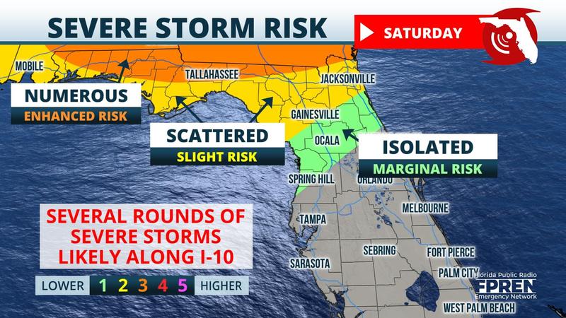
The severe weather risk will begin to increase Saturday, especially across the Florida Panhandle as the warm front situates itself to the north of the state and a cold front approaches from the west. This will place most of the Panhandle and North Florida in a “warm sector”. Within this section temperatures and moisture will be high allowing for the development of showers and thunderstorms.
Weather models are indicating moderate wind shear with atmospheric instability increasing in the afternoon. This environment will be favorable for severe thunderstorms capable of producing strong winds, small hail, and isolated tornadoes. Heavy rainfall will also be a concern, especially for areas that have received an abundant amount of rainfall from the previous event which took place last weekend. Isolated flash flooding will be possible through the weekend.
The Storm Prediction Center, as of Thursday afternoon, has so far issued a Slight Risk (hazard level 2 out of 5) for the entire Florida Panhandle and Big Bend area for Saturday. A Marginal Risk (hazard level 1 out of 5) extends into parts of North Florida extending from Cedar Key, through Gainesville, and towards Jacksonville. This could change over the next few days as the event draws closer. However, residents in the Florida Panhandle and North Florida should be prepared for the chance of strong to severe thunderstorms mainly for Saturday.
The cold front is anticipated to move through the western Florida Panhandle during the morning hours on Saturday before approaching the Big Bend and North Florida towards the afternoon and evening. Overnight into Sunday the cold front will continue to move steadily southeastward towards Central Florida. The frontal boundary should exit into the Atlantic by the end of the day Sunday allowing for high pressure to build back into the Sunshine State making for a sunnier and drier start to the new work week.


