The official start to the 2021 Atlantic Hurricane Season is less than a month away, and with several forecast agencies predicting another active year, now is the time to prepare.
Hurricanes are not just a coastal problem. Life and property can also be at risk hundreds of miles inland. The hazards, however, are not the same for all locations.
Most residents in hurricane prone areas understand how intense the winds can be but many may not realize, or prepare for, other hazards a storm presents.
Understanding one’s risk is the first step to preparing for the possible life-altering effects from a storm.
Storm surge is the abnormal rise in seawater level during a storm, measured as the height of the water above the normal predicted astronomical tide. The surge height can be up to two stories tall along the coast and can flood communities and neighborhoods several miles inland. The water is often driven by hurricane force winds, moving at a rate of up to one mile every four minutes. It can also be filled with dangerous debris, sewage, and electrical currents from fallen power lines.
According to a National Hurricane Center study, out of the 2,325 direct fatalities recorded between 1963 and 2012 roughly 90% occurred in water-related incidents, most by drowning. Storm surge was responsible for about half of all fatalities (49%).
The Federal Alliance for Safe Homes (FLASH) says that the first step to understanding your storm surge risk is to know your evacuation zone. You can find your zone in the Florida Storms app by tapping the menu item “Evacuate”.
Tropical cyclones are known for their powerful winds, and they are not just confined to coastal areas. Hurricane-force winds can travel far inland after a hurricane makes landfall, causing considerable structural damage and power outages that can last days, sometimes weeks.
The Saffir-Simpson Hurricane Wind Scale categorizes a storm from 1 to 5 based on the intensity of the winds. However, when the National
Hurricane Center issues a statement to the public concerning the wind and category, that value is for sustained winds only. The hurricane scale does not include gusts or squalls.
The highest wind speeds are typically found in the eye wall of the hurricane and generally in the area to right of the eye, known as the right-front quadrant. This section of the storm tends to also have the most damaging storm surge. Areas that are forecast to go through this quadrant typically experience the heaviest damage. This powerful quadrant can sustain its strength over land for some time before the tropical cyclone begins to weaken.
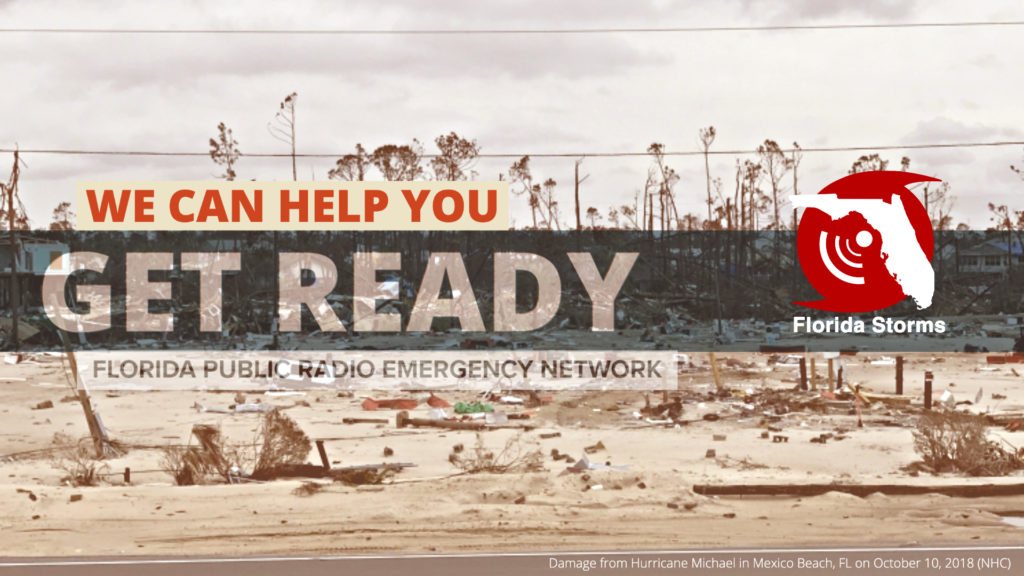
Category 5 Hurricane Michael came ashore near Mexico Beach, Florida in October 2018. Areas along the shoreline experienced catastrophic damage from winds up to 160 mph. The storm maintained its major hurricane strength as it pushed into Georgia, more than 60 miles from where it came ashore, continuing to flatten homes and topple trees. The strong winds from Michael also caused extensive power outages as far north as Virginia, more than 24-hours after landfall.
The two most important steps to prepare for the wind is to strengthen your home and build a supply kit. Supply kit checklists, such as this printable one from FEMA, are a great resource to have in hand while shopping.
Tropical cyclones also threaten the United States with torrential rains and flooding. Even after the strong winds have diminished, the flooding potential of these storms can remain for several days.
A common misconception is to believe that the higher the category of a storm, the greater the potential for flooding. This is not always the case. In fact, large and slow-moving tropical cyclones, regardless of strength, are the ones that usually produce the most flooding. This was evident with Tropical Storm Allison in 2001 which devastated portions of southeast Texas with severe flooding, despite only having maximum winds of 60 mph.
Sixteen years later it would happen again, in the same area. In 2017, Hurricane Harvey came ashore as a major Category 4 hurricane before quickly weakening over southeast Texas. Although Harvey quickly weakened to a Tropical Storm, the system became almost stationary over the region for days. Southeast Texas saw the worst of the flooding as heavy rains delivered more than 40 inches of rain to some areas in less than 48-hours.
Since 1970, nearly 60% of the 600 deaths due to floods associated with tropical cyclones occurred inland from the storm’s landfall. Of that 60%, almost a fourth (23%) of U.S. tropical cyclone deaths occur to people who drown in, or attempting to abandon, their cars.
A homeowner’s insurance does not always cover flooding. It is also widely believed that the federal government can pay for your damages after a flood. While some agencies do provide assistance after a major event, the amount typically comes up far short of what it actually costs to fully restore one’s property or livelihood. When preparing for the season ahead, consider purchasing flood insurance from the National Flood Insurance Program (NFIP) as soon as possible.
Tropical cyclones often produce tornadoes, which can contribute to the overall destructive power of a storm. Similar to storm surge and extreme wind, tornadoes are more likely to occur in the right-front quadrant of the hurricane relative to its motion. However, they can also be found throughout the storm.
Tornadoes associated with tropical cyclones are usually less intense than those that occur in Tornado Alley and Dixie Alley. Although these tornadoes are generally weak, the effects of tornadoes can produce substantial damage for anyone in the path of an approaching hurricane. Residents are advised to have multiple ways of receiving alerts during a hurricane, such as tornado warnings, should there be a loss of power. The use of a battery-powered NOAA weather radio or a mobile app with push notifications is encouraged.
Developing and reviewing an evacuation plan is crucial as hurricane season draws near. Learn your evacuation zone and know where to go in the event of an evacuation order.
Collect and assemble a disaster supply which includes food, water, medication, important documents, and sentimental items.
Strengthen your home and check on family, friends and neighbors. Help individuals collect supplies before the storm and assist them with evacuation if ordered to do so. Check in on them, especially the elderly, after the storm has passed and it is safe to do so.
The official start of the Atlantic Hurricane Season begins June 1st and lasts through November 30th. However, the Atlantic has produced early-season cyclones over the last six consecutive years. The time to prepare is now, before the formation of a storm.


