Uncertainty is "larger than usual" in the long-range forecast for Hurricane Elsa, according to the National Hurricane Center. However, forecasters say storm surge, wind, and rainfall impacts are all possible across portions of Florida early next week.
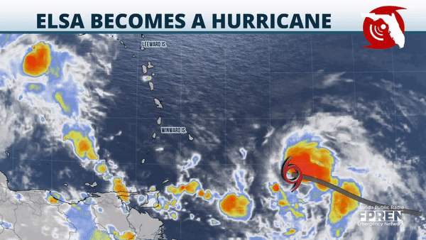
The season's fifth tropical storm was racing toward the Lesser Antilles early Friday, with maximum winds of 75 mph and a motion to the west-northwest at 28 mph. Tropical Storm Warnings were upgraded to Hurricane Warnings for the central Windward Islands and a Hurricane Watch was issued for the southern coast of Haiti.
The official forecast track brings Elsa into the eastern Caribbean late Friday, with a trek to the west-northwest Saturday south of Hispaniola, followed by a deceleration and slight northwest turn near the southeastern coast of Cuba Sunday. Gradual intensification is expected over the next 48 hours due to warm sea-surface temperatures, light wind shear and adequate moisture. However, uncertainty abounds on the track, strength and speed of the storm thereafter.
The storm's fast forward speed is one of the many factors contributing to the low-confidence forecast. Strong easterly steering winds could make it difficult for the low- and mid- level circulations to remain in sync along its journey through the eastern Caribbean Sea. Conversely, much weaker upper-level winds are expected to have less of an influence over Elsa when it reaches the northern Caribbean Sea, making subtle changes in its trajectory difficult to pin down.
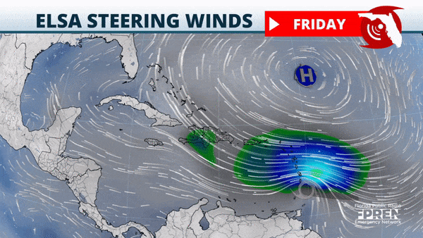
At the same time, however, the lighter winds aloft and warmer sea-surface temperatures could enable the storm to intensify at a faster rate than what is explicitly forecast. But complicating matters further are the possible land interactions Elsa may have with the mountainous terrain of Cuba and/or Hispaniola, which could disrupt Elsa's circulation and cause the storm to weaken.
All of these factors yield significant variations in possible affects Floridians might experience from Hurricane Elsa. Therefore, vigilance over action is the best approach for now.
Floridians are encouraged to consider preparations they might be able to complete over the holiday weekend if Elsa were to become a more significant threat by Monday. Periods of heavy rain and strong thunderstorms may make this difficult at times across sections of North Florida and in the Panhandle due to an approaching front. This activity withstanding, a near-normal weather pattern for mid-summer will stay in place through the duration of the upcoming holiday until potential influences from Hurricane Elsa in South Florida Monday.
Elsa became the earliest fifth named storm on record for the tropical Atlantic basin, surpassing the previous calendar year record set in 2020 by Tropical Storm Edouard on July 5. Updates on Tropical Storm Elsa will be available around the clock and from official sources in the Florida Storms mobile app.


