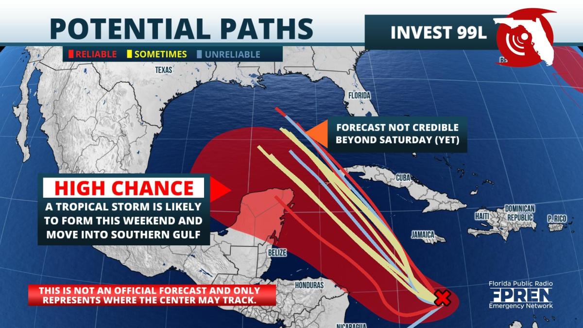
Update as of 8:30am Thursday: A new tropical depression or tropical storm is likely to form Thursday afternoon or evening over the western Caribbean. Atmospheric conditions favor strengthening once it enters the southern or western Gulf of Mexico this weekend.
For tracking purposes and to run models on the developing system, meteorologists are calling this disturbance "99L". Nearly all of the major global models bring the storm near or over western Cuba Friday evening and over the Gulf of Mexico on Saturday. The water is plenty warm enough for strengthening, but wind shear may limit its rate of intensification for another day or so. Upper-level winds in the Gulf, combined with the very warm water, will favor significant intensification over the Gulf of Mexico.
The National Hurricane Center is advising all interests along the Gulf coast from Texas to the western Florida Panhandle to monitor future forecasts for possible rain, wind, or surge impacts that could occur as soon as late Sunday.
Original story as of 9:00am Wednesday: A new tropical depression is likely to form late this week or weekend over the western Caribbean. Atmospheric conditions favor strengthening once it enters the southern or western Gulf of Mexico by Sunday.
Showers and thunderstorms associated with the tropical wave near the coast of northern Columbia are more concentrated Wednesday morning. Most of the reliable global models are forecasting the wave to become a tropical cyclone Friday or Saturday in the western Caribbean. It is likely to pass close to the Yucatan Peninsula or western Cuba during the time before entering the Gulf of Mexico later this weekend.
A ridge of high pressure is forecast to extend from Florida into Georgia and the Carolinas. Normally, a ridge in that position directs storms toward the central or western Gulf of Mexico. The warm waters of the Gulf and low wind shear strongly suggest this system will strengthen after it gets there. There are still plenty of questions regarding exactly where this storm will form and just how strong the high pressure ridge will be. These two factors will play a large role in determining where the system eventually ends up.
Emergency management professionals and meteorologists advise residents along or near the Gulf and Atlantic coasts to have a hurricane preparedness plan and kit well before a storm becomes a threat to land areas.
 There are two other areas forecasters are monitoring. A trough of low pressure about 800 miles southeast of Bermuda is likely to develop into a depression or named storm over the weekend, but is likely to stay out at sea east of Bermuda through early next week. A separate tropical wave several hundred miles west-southwest of the Cabo Verde Islands has a small chance of developing over the next day or two before stronger upper-level winds arrive this weekend and likely prevent further development.
9(MDA5NDY0MjA5MDEzMzcwMjQ4MTUxZWMwMg004))
