Hurricane Ida has come ashore in southeast Louisiana, but the indirect hazards are just beginning in portions of the Florida Panhandle. Flash flooding, coastal flooding, and isolated tornadoes remain possible through Monday along the Emerald Coast as Ida moves inland.
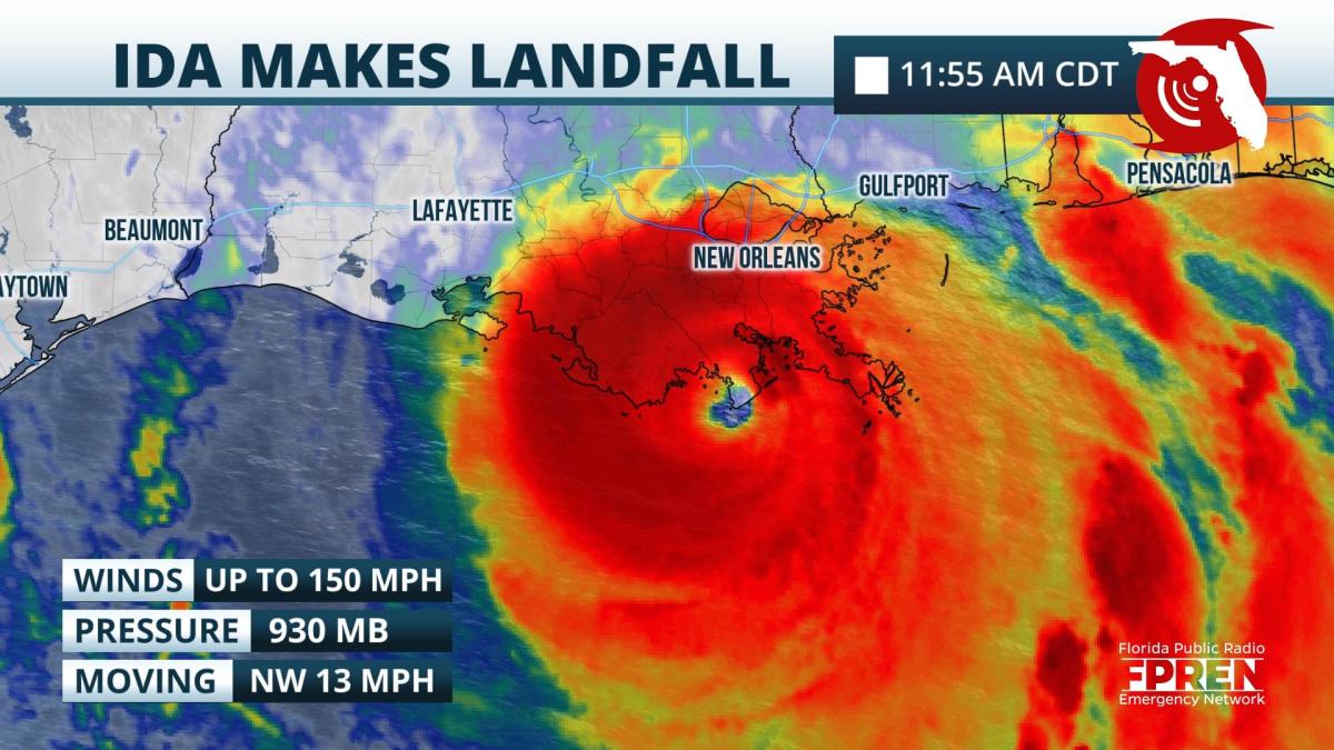
Hurricane Ida made landfall near Port Fourchon, LA shortly before 12 pm CDT Sunday, according to a special update from the National Hurricane Center. At the time, maximum winds were estimated to be at 150 mph and the pressure as low as 930 mb. Life-threatening storm surge and inland flooding, along with potentially catastrophic wind damage is still expected from the hurricane as it moves inland Sunday afternoon and evening near and west of New Orleans to Baton Rouge.
Outer rainbands from Ida moved through much of the Florida Panhandle Sunday morning, and in a few cases prompted tornado and flash flood warnings.
This trend is likely to continue through Monday night, with the heaviest and most persistent bands coming in two general waves. As Ida's circulation moves inland and expands Sunday afternoon, another outer rain band or two will rotate across the Panhandle through the early evening hours. A lull in activity is expected overnight Sunday as Ida tracks a little west of north through Louisiana. However, as the storm's center moves more east of north, into portions of Mississippi on Monday, rain bands will move back in the direction of Pensacola and the Emerald Coast. This is when the flash flood risk will be enhanced, especially in areas that receive heavy rain from both rounds.
The following alerts have been issued by the National Weather Service for portions of the Florida Panhandle:
Outer rainbands from Hurricane Ida are likely to begin approaching Florida's Emerald Coast and Pensacola as early as Sunday morning. As some limited sunshine destabilizes the atmosphere a bit more farther east, additional rain squalls are likely to develop and intensify near Panama City and Tallahassee by late Sunday afternoon, potentially stretching as far south as the Nature Coast, Tampa and Sarasota by early evening.
Isolated tornadoes will be possible in the strongest cells associated with Ida's aforementioned outer rainbands Sunday, especially near and west of Tallahassee. The tornado risk may continue in some of these areas Tuesday.
A Flash Flood Watch has been issued for Escamba, Santa Rosa and coastal Okaloosa counties in Florida through Tuesday morning. In these locations, rainbands will be more persistent Sunday night and Monday, closer to where Ida's center of circulation moves inland. Rainfall accumulations of 4 to 6 inches are expected in the watch area, with locally higher amounts up to 8 inches possible. Rainfall accumulations of 8 to 16 inches are expected closer to where the center of Hurricane Ida tracks through southeast Louisiana and southern Mississippi.
A life-threatening storm surge of 8 to 16 feet above normally dry ground is expected at times of high tide from Morgan City, LA to the Mouth of the Mississippi River. The water inundation is likely to be 5 to 8 feet in Lake Pontchartrain and 6 to 12 feet east to the Mississippi-Alabama border. A water rise of 2 to 4 feet is possible farther east to the Alabama-Florida border, with 1 to 3 feet possible near Pensacola and along the Emerald Coast.
Significant wind damage and widespread power outages are expected across southeast Louisiana, where hurricane warnings are in effect. Sporadic outages and minor wind damage are possible east of across portions of coastal Mississippi and Alabama, where tropical storm warnings have been issued. An occasional wind gust to 40 or 50 mph cannot be ruled out in the Florida Panhandle from Ida, but it would be more isolated and primarily associated with the heavier outer rain bands.
Hurricane Ida is expected to weaken rapidly after landfall, but still be capable of producing rough seas and heavy rain bands across the Florida Panhandle Monday and Tuesday. The remnant moisture feed on the storm's eastern side is also likely to move back in the direction of Florida Tuesday, leading to higher-than-normal rain chances across north and central sections of the state through Wednesday.
Updates on Hurricane Ida, including the latest advisory and any urgent alerts related to the storm, are available in the Florida Storms mobile app. This is a free download from the Florida Public Radio Emergency Network.
9(MDA5NDY0MjA5MDEzMzcwMjQ4MTUxZWMwMg004))


