English English Spanish EspaƱol
Powered by WUFT
Temporarily change filter
Finding your station
THIS STORY HAS EXPIRED

Heavy Rain Shifts Southeast, Tropics Stay Active This Week

September 19, 2021

Two days of heavy rain prompted flood watches and warnings across the northern third of Florida this weekend. The heavy rain risk will shift south this week, while the tropics stay active but non-threatening.

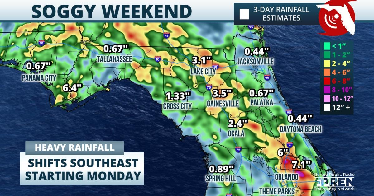
Three to five inches of rain has been observed or radar estimated across inland areas of north and central Florida since Friday, and isolated amounts over three inches have also been noted in the Panhandle. The tropical moisture responsible for the weekend washout is forecast to shift east and south in the coming days, enhancing the daily shower and thunderstorm activity across central and south Florida by midweek. Localized flooding will be possible where storms repeatedly produce heavy rain over the same areas multiple days in a row.

PGRpdiBpZD0iYmFyb24td2lkZ2V0LWRpdi1tYXAtZGVza3RvcC1oIiBzdHlsZT0iaGVpZ2h0OiA2MDBweDsgd2lkdGg6IDEwMCU7IiBjbGFzcz0iYmFyb24td2VhdGhlci13aWRnZXQiPjxkaXYgaWQ9ImxlYWRlcmJvYXJkLWFkLWNvbnRhaW5lci1tYXAtZGVza3RvcC1oIiBzdHlsZSA9ICJ0ZXh0LWFsaWduOiBjZW50ZXI7Ij48L2Rpdj48aWZyYW1lIGlkPSJiYXJvbi13aWRnZXQtZnJhbWUtbWFwLWRlc2t0b3AtaCIgbmFtZT0ibWFwLXdpZGdldCIgc3JjPSJodHRwczovL3N0YXRpY2Jhcm9ud2ViYXBwcy52ZWxvY2l0eXdlYXRoZXIuY29tL2RpZ2l0aWFsX3d4L3BhZ2VzL24yLmFkYXB0aXZlL21hcC9pbmRleC5odG1sP2luaXRqc29uPWh0dHBzOi8vc3RhdGljYmFyb253ZWJhcHBzLnZlbG9jaXR5d2VhdGhlci5jb20vZGlnaXRpYWxfd3gvd2lkZ2V0cy9kY21zLzUyZTVjM2VkLWRhNTAtNGYyNy05MzEzLWNkZjVjMzQ2ODFlYy9saXZlL2luaXQuanMmaW5pdGpzb252YXI9aW5pdGRhdGEiIG1hcmdpbndpZHRoPSIwIiBtYXJnaW5oZWlnaHQ9IjAiIGhlaWdodD0iMTAwJSIgd2lkdGg9IjEwMCUiIGZyYW1lYm9yZGVyPSIwIiBzY3JvbGxpbmc9Im5vIiBzdHlsZT0iei1pbmRleDogMTsgcG9zaXRpb246IHN0YXRpYzsgdG9wOiAwOyBsZWZ0OiAwOyBmbG9hdDogbGVmdDsiPm5vIGlmcmFtZSBzdXBwb3J0ITwvaWZyYW1lPjxkaXYgaWQ9InNreXNjcmFwZXItYWQtY29udGFpbmVyLW1hcC1kZXNrdG9wLWgiIHN0eWxlID0gImZsb2F0OiBsZWZ0OyI+PC9kaXY+PHNjcmlwdD4oZnVuY3Rpb24oKSB7IHZhciBza3lzY3JhcGVyID0gZG9jdW1lbnQuZ2V0RWxlbWVudEJ5SWQoJ3NreXNjcmFwZXItYWQtY29udGFpbmVyLW1hcC1kZXNrdG9wLWgnKTsgdmFyIGlmcmFtZSA9IGRvY3VtZW50LmdldEVsZW1lbnRCeUlkKCdiYXJvbi13aWRnZXQtZnJhbWUtbWFwLWRlc2t0b3AtaCcpOyB2YXIgd3JhcHBlcldpZHRoID0gZG9jdW1lbnQuZ2V0RWxlbWVudEJ5SWQoJ2Jhcm9uLXdpZGdldC1kaXYtbWFwLWRlc2t0b3AtaCcpLm9mZnNldFdpZHRoOyB2YXIgc2t5c2NyYXBlcldpZHRoID0gc2t5c2NyYXBlci5vZmZzZXRXaWR0aDsgdmFyIGlmcmFtZVdpZHRoID0gd3JhcHBlcldpZHRoIC0gc2t5c2NyYXBlcldpZHRoOyBpZnJhbWUuc2V0QXR0cmlidXRlKCJ3aWR0aCIsIGlmcmFtZVdpZHRoKTsgdmFyIGxlYWRlcmJvYXJkID0gZG9jdW1lbnQuZ2V0RWxlbWVudEJ5SWQoJ2xlYWRlcmJvYXJkLWFkLWNvbnRhaW5lci1tYXAtZGVza3RvcC1oJyk7IHZhciB3cmFwcGVySGVpZ2h0ID0gZG9jdW1lbnQuZ2V0RWxlbWVudEJ5SWQoJ2Jhcm9uLXdpZGdldC1kaXYtbWFwLWRlc2t0b3AtaCcpLm9mZnNldEhlaWdodDsgdmFyIGxlYWRlcmJvYXJkSGVpZ2h0ID0gbGVhZGVyYm9hcmQub2Zmc2V0SGVpZ2h0OyB2YXIgaWZyYW1lSGVpZ2h0ID0gd3JhcHBlckhlaWdodCAtIGxlYWRlcmJvYXJkSGVpZ2h0OyBpZnJhbWUuc2V0QXR0cmlidXRlKCJoZWlnaHQiLCBpZnJhbWVIZWlnaHQpOyBpZiAod2luZG93LmFkZEV2ZW50TGlzdGVuZXIpIHsgd2luZG93LmFkZEV2ZW50TGlzdGVuZXIoIm1lc3NhZ2UiLCBmdW5jdGlvbihldmVudCkgeyBiYXJvbl93ZWF0aGVyX21hcG1heGltaXplKGV2ZW50LmRhdGEsIGV2ZW50Lm9yaWdpbik7IH0sIGZhbHNlKTsgfSBlbHNlIHsgd2luZG93LmF0dGFjaEV2ZW50KCJvbm1lc3NhZ2UiLCBmdW5jdGlvbigpIHsgYmFyb25fd2VhdGhlcl9tYXBtYXhpbWl6ZSh3aW5kb3cuZXZlbnQuZGF0YSwgd2luZG93LmV2ZW50Lm9yaWdpbik7IH0pOyB9IGZ1bmN0aW9uIGJhcm9uX3dlYXRoZXJfbWFwbWF4aW1pemUoZG9tYXgsIG9yaWdpbikgeyBpZiAoZG9tYXgudG9TdHJpbmcoKSA9PSAidHJ1ZSIpIHsgaWZyYW1lLnN0eWxlLnBvc2l0aW9uID0gImZpeGVkIjsgaWZyYW1lLnNldEF0dHJpYnV0ZSgid2lkdGgiLCAiMTAwJSIpOyBpZnJhbWUuc2V0QXR0cmlidXRlKCJoZWlnaHQiLCAiMTAwJSIpOyB9IGVsc2UgaWYgKGRvbWF4LnRvU3RyaW5nKCkgPT0gImZhbHNlIikgeyBpZnJhbWUuc3R5bGUucG9zaXRpb24gPSAic3RhdGljIjsgaWZyYW1lLnNldEF0dHJpYnV0ZSgid2lkdGgiLCBpZnJhbWVXaWR0aCsicHgiKTsgaWZyYW1lLnNldEF0dHJpYnV0ZSgiaGVpZ2h0IiwgaWZyYW1lSGVpZ2h0KyJweCIpOyB9IH0gfSkoKTs8L3NjcmlwdD48L2Rpdj4=
FLORIDA STORMS
Tap to open or download our mobile app

The greatest coverage and intensity of Monday's storm activity will be across northeast and central sections of the peninsula, where a southwesterly wind enhances storm coverage along the Atlantic sea breeze by late afternoon. The heaviest downpours are likely Monday near or east of I-75 from Lake City to The Villages, then along and north of the I-4 corridor from Lakeland to Orlando, and up I-95 from Daytona Beach to Jacksonville. Elsewhere across Florida, showers are possible in the morning hours closer to the Gulf Coast, with spotty thunderstorms expected across inland areas by afternoon.

On Tuesday and Wednesday, the axis of heavier afternoon and evening rains will spread southeast to include the Space Coast, the Treasure Coast and portions of South Florida. Meanwhile, a shift in the winds will allow drier air to work its way into the northern half of Florida, effectively limiting afternoon sea breeze activity to only a few brief and spotty showers near and north of I-4. This trend is likely to continue through Friday, and may even be reinforced by the approach of a true fall front moving into the northern third of the state.

In the tropics, two new tropical storms formed over the weekend in the Atlantic Ocean. Neither are expected to be a threat to the United States. Tropical Storm Peter was located 350 miles east of the northern Leeward Islands Sunday evening, while Tropical Storm Rose was 370 miles south of the Cabo Verde Islands. Both storms are forecast to move more north than west and stay over the open waters of the Atlantic in the next five days.

NO CURRENT STORMS IN ATLANTIC BASIN

Two other areas of disturbed weather were also being monitored for possible development by the National Hurricane Center Sunday evening. The remnant circulation and moisture from Odette was moving south of Newfoundland and had a "low" chance of reacquiring tropical characteristics. The second area noted was a tropical wave expected to move into the eastern Atlantic Ocean from Africa, where forecasters say it has a "medium" chance of developing into a tropical depression or storm by Friday. Neither of these disturbances poses a threat to land through over at least the next seven days.

WATCHING CLOSELY
NHC: Low chance of tropical development in next five days.
LOCAL ALERTS
WEATHER
NEWS
TRAFFIC
Sources include nearest National Weather Service office, National Hurricane Center, and the Florida Public Radio Emergency Network (@FloridaStorms).
Sources include nearby emergency management agencies, FEMA, and your local NPR affiliate. 
Sources include the Florida Department of Transportation, Florida Highway Patrol and other nearby traffic information.

1885 Stadium Road
PO Box 118405
Gainesville, FL 32611
(352) 392-5551

A service of WUFT at the University of Florida College of Journalism and CommunicationsĀ 

Partners of the Florida Public Radio Emergency Network include: Florida's Division of Emergency Management, WDNA (Miami), WFIT (Melbourne), WMFE (Orlando), WFSU (Tallahassee), WGCU (Fort Myers), WJCT (Jacksonville), WKGC (Panama City), WLRN (Miami), WMNF (Tampa-Sarasota), WQCS (Fort Pierce), WUFT (Gainesville-Ocala), WUSF (Tampa), WUWF (Pensacola) and Florida Public Media.

Loading...
linkedin facebook pinterest youtube rss twitter instagram facebook-blank rss-blank linkedin-blank pinterest youtube twitter instagram