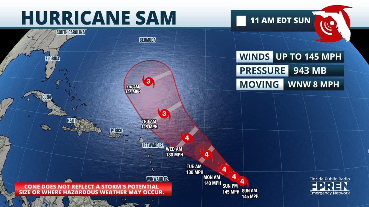
Update as of 11am Sunday: Sam continued to strengthen Saturday afternoon and evening, attaining category 4 intensity on the 5pm Saturday advisory. Sam had top sustained winds of 145 mph as of Sunday morning. Its intensity is forecast to fluctuate, but the Hurricane Center forecast maintains Sam as a major hurricane — category 3 or higher — through the upcoming week.
All model simulations that compromise of the U.S. and European ensemble are now forecasting Sam to miss the northern Leeward Islands Wednesday and Thursday, when the storm is likely to be at its closest approach. A turn more toward the north-northwest is forecast on Friday, which would hold the storm well south of Bermuda through that time.
The Southeast U.S. coast is not likely to see any direct impacts from Sam, but increasing swell may start arriving on Atlantic beaches from Florida to the Carolinas on Thursday. The swell is likely to increase Friday into next weekend. Swimmers and visitors to Atlantic beaches next weekend should bear this in mind and check on forecasts later in the week.
 Two other disturbances closer to the coast of Africa have a chance of becoming tropical depressions during the middle or latter part of the week.
Original story from Saturday afternoon: Hurricane Sam reached category 3 status late Saturday morning, becoming the fourth Atlantic hurricane to achieve major hurricane status in 2021.
As of midday Saturday, Sam was located a little less than 1100 miles east of the Lesser Antilles with top sustained winds of 120 mph. It is moving toward the west-northwest at about 10 mph. The National Hurricane Center is forecasting Sam to attain category 4 intensity on Sunday, slow its forward motion, and turn more toward the northwest on Monday. The hurricane itself is compact: hurricane force winds extend outward up to 25 miles from the center and tropical storm force winds extend 105 miles away from Sam's eye.
The forecast track keeps the eye of Hurricane Sam north and east of the Leeward Islands by Thursday. It is still unclear how close the center will come to those islands, but there is still a chance of peripheral effects from the hurricane. Nearly all of the global models and their ensembles predict Sam to turn toward the north and stay over the open Atlantic through the upcoming week. It is not possible to confidently say whether Sam will miss the U.S. coastline, but longer term models are favoring that scenario.

A strong hurricane over the Atlantic almost always generates swell, much like Hurricane Larry did earlier in the month. The most recent simulations from America's global model shows long-period swell reaching the Atlantic coastline of the United States next weekend. Those planning to enter the Atlantic Ocean next weekend to swim or surf should monitor forecasts later this week as rip currents could become a concern.
Subtropical Storm Teresa formed late Friday afternoon north of Bermuda. It weakened to a subtropical depression Saturday morning and will move out into the open Atlantic. The remnant of what was once Tropical Storm Peter has a small chance of regenerating well south of Bermuda early this upcoming week, but it is not expected to threaten land areas. Finally, another tropical wave is expected to move off the coast of Africa on Monday. It has a good chance of becoming the season's next tropical depression during the middle of the week over the Tropical Atlantic.
9(MDA5NDY0MjA5MDEzMzcwMjQ4MTUxZWMwMg004))


