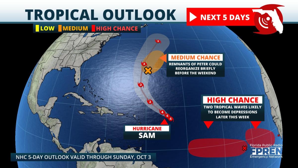
Update as of 9:30am Tuesday: Sam remains a major hurricane about 600 miles from the Leeward Islands. It briefly weakened to a category 3 hurricane Monday, but regained category 4 intensity Tuesday morning. It is forecast to move northwestward and miss the Leeward Islands through Thursday, followed by a northward turn this weekend. The latest track keeps Hurricane Sam east of Bermuda. Swells are still forecast to reach the Atlantic coast Thursday and Friday. These swells should peak Saturday morning and slowly diminish on Sunday. Swimmers at Atlantic coast beaches are encouraged to monitor beach conditions.
A tropical wave a few hundred miles south-southeast of the Cape Verde Islands, now classified as "Invest 90L", is still likely to become a depression Wednesday or Thursday. Most forecast models turn 90L toward the north over the open waters of the eastern Atlantic over the upcoming weekend.
Another disturbance is located a few hundred miles south-southwest of the Cape Verde Islands. This disturbance is recognized as "Invest 91L" for tracking purposes. It, too, is likely to become a depression according to the National Hurricane Center either Wednesday or Thursday. Some models turn 91L northward, while others keep it moving toward the Caribbean by early next week.
Original Story from Monday morning: Hurricane Sam matched Hurricane Ida as the season's strongest hurricane late Sunday, but is forecast to stay at sea. Two new tropical depressions are likely to form behind Sam, closer to the coast of Africa this week.
Sam's sustained winds topped out at 150 mph Sunday, but those winds have come off their peak by Monday morning thanks to a process called an eyewall replacement cycle. Typically, hurricanes will form concentric eyes, where the inner eye weakens and gives way to a larger, outer eye. The new larger eye then contracts and the same process can happen several times during a hurricane's lifecycle. These eyewall replacement cycles will cause Sam's intensity to fluctuate upward and downward over the next few days. The official forecast from the National Hurricane Center keeps Sam at a major hurricane — category 3 intensity or greater — through Friday.
A strong trough of low pressure moving off the U.S. East coast is expected to block Sam, and instead direct it northward later this week into the weekend. On its projected path, the powerful hurricane will bypass the Leeward Islands to the north Wednesday and Thursday, and likely pass east of Bermuda over the weekend. However, a small portion of the forecast cone covers Bermuda, so impacts are still possible over the island.
Even though Sam is not expected to directly impact the Southeast U.S. coastline, swells from the hurricane may contribute to dangerous rip currents along the Atlantic beaches, especially Friday through the upcoming weekend. Those planning to enter the ocean should check forecasts later this week, swim near lifeguards, and watch for beach flags that will inform swimmers of expected conditions.
There are two disturbances behind Sam that are likely to become tropical depressions. Both are forecast to stay over the deep tropics through the upcoming weekend. The remnant of what was once Tropical Storm Peter is located about 300 miles east-southeast of Bermuda. The National Hurricane Center says it could briefly become a tropical depression again Tuesday or Wednesday before moving to the northeast, out into the open Atlantic Ocean.
9(MDA5NDY0MjA5MDEzMzcwMjQ4MTUxZWMwMg004))
