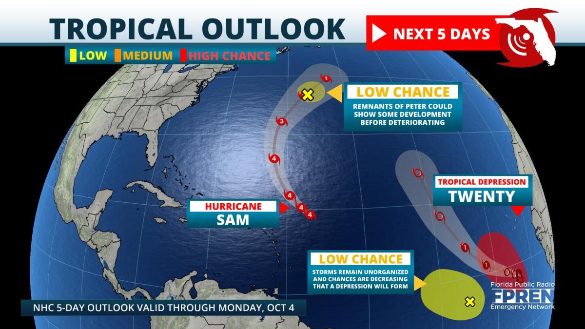
Update as of 11am Wednesday: The tropical wave, referred to as "Invest 90L", south of the Cape Verde Islands has become Tropical Depression Twenty according to the National Hurricane Center. It is forecast to become a tropical storm later Wednesday, and a hurricane by Friday. The forecast track keeps it out over the open Atlantic, far away from the U.S. coastline. The next name on the list is "Victor"; it is the second to last name on the primary season's list.
Original story from 9:45am Wednesday: Hurricane Sam is not expected to reach the U.S. coast, but beachgoers will feel the effects in the form of swell starting in a day or two.
Hurricane Sam is near its closest approach to the Caribbean; it's about 450 miles east of the Leeward Islands. It's expected to miss those islands and turn northward on Friday and then northeast a couple hundred miles to the east of Bermuda on Saturday. Swells from Sam will gradually reach the Atlantic coastline from the Carolinas to Florida Thursday and Friday, then peak on Saturday. The swell will continue on Sunday, but gradually diminish early next week.
Heavy showers and thunderstorms are located off the coast of Africa that are tied to a natural phenomenon called the monsoon trough. The trough forms where northeasterly trades and southeasterly trades meet up near or south of the Cape Verde Islands. Forecasters have been monitoring two disturbances within the monsoon trough: "Invest 90L" and "Invest 91L". 90L is situated a couple hundred miles south of the Cape Verde Islands, and is most likely to become a tropical depression later Wednesday. The development of 91L, which is a few hundred miles west of 90L, is a lot less likely than it appeared just yesterday. Both systems are currently forecast to turn northward and not get on this side of the Atlantic Ocean.
Global models are forecasting a substantial increase in moisture from the central Caribbean northward to near the Carolina coast next week. There are no indications of a tropical system forming at this time, but this area is climatologically favored for development in October and will have to be monitored for possible changes.
9(MDA5NDY0MjA5MDEzMzcwMjQ4MTUxZWMwMg004))
