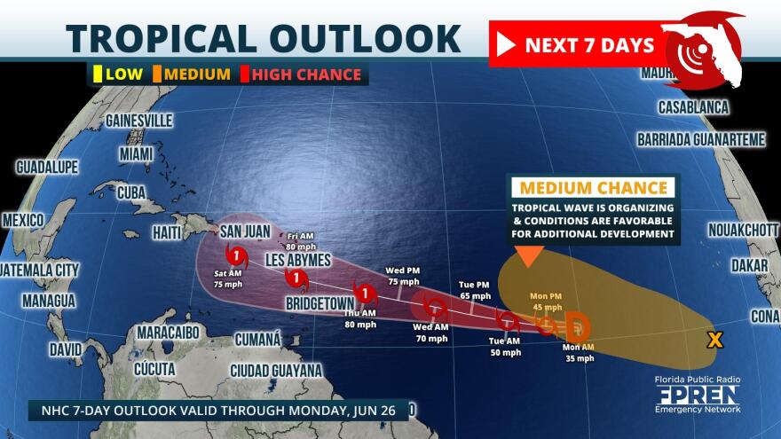
Tropical Depression Three has formed in the Central Tropical Atlantic and continued strengthening is likely. Most tropical model guidance keeps the system on a slow track toward the Caribbean through the end of the week. Conditions are favorable for further development the next few days, so there’s a high chance it will become a tropical storm, or even our first hurricane (Bret) of the season.
As the depression attempts to close in on the Lesser Antilles and Caribbean, conditions become a little less favorable for intensification, but abnormally warm waters may offer plenty of fuel.
Another wave in the Eastern Tropical Atlantic has become better organized today, and conditions support evolution into a depression later this week.

Although both waves will be moving through the overall Main Development Region (MDR) of the Atlantic hurricane season, this not the most likely area during June. Only 6% of all tropical systems form in June, and of the storms that do evolve, the majority form in the Gulf of Mexico. Climatology shows the 3 earliest named June storms in tropical Atlantic are:
TS Bret: June 19, 2017
TS Ana: June 22, 1979
1933 Trinidad Hurricane: June 25

El Nino has officially kicked in this season which historically decreases tropical cyclone activity in the Atlantic Basin. However, historically warm sea surface temperatures across the MDR that are already in place, may continue to enhance development the next several months.
There is still lots of uncertainty with both tropical systems, so please download the Florida Storms app to track the tropics and keep you prepared at all times.

