The peak of the Atlantic hurricane season is approaching, and despite a recent lull in activity, the National Oceanic and Atmospheric Administration (NOAA) still expects an above-average season. Among other factors, La Niña continues to play a significant role in tropical development for the remainder of the season.
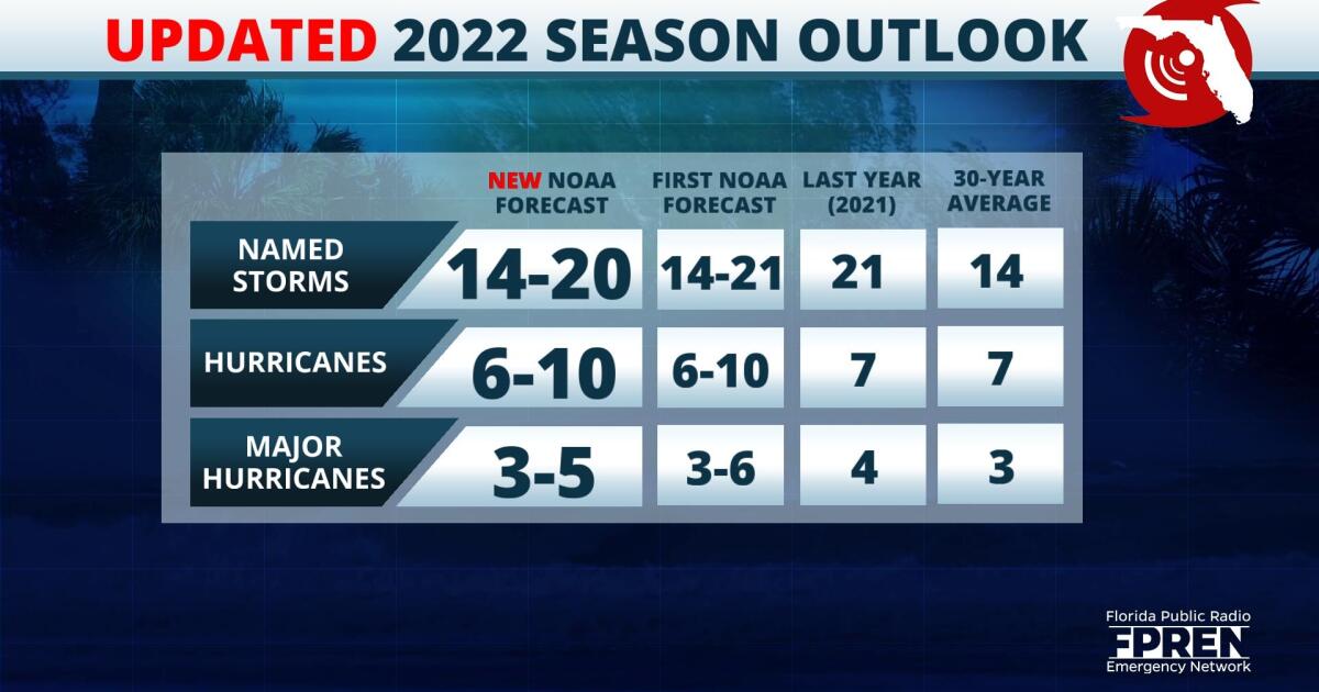
Forecasters at NOAA's Climate Prediction Center released their mid-season outlook Thursday and little has changed from their first outlook issued in May. If the forecast verifies, it will mark the seventh consecutive year of above-average tropical activity. The number of forecasted named storms shifted slightly down from the original outlook and is now expected to fall within a range of 14-20 named storms. Of those, 6-10 are expected to become hurricanes and 3-5 of those are likely to become major hurricanes.
,Favorable atmospheric conditions coupled with an ongoing La Niña are still expected to lead to an above-average hurricane season. The impact La Niña has on the tropics is significant, as this phase of the El Niño-Southern Oscillation weakens westerly winds in the upper atmosphere. This results in a wind pattern over the Atlantic basin that is favorable for an increase in tropical activity and typically stronger hurricanes.
Forecasters also look at sea surface temperatures when developing their seasonal outlook, as warm waters assist in the genesis and strengthening of tropical cyclones. The latest data depicts temperature anomalies of up to 3 degrees Celsius over parts of the Main Development Region (MDR), which is the area of the Atlantic basin where nearly 75 percent of major hurricanes originate. Forecasters say that although outbreaks of cooler water are possible over parts of the MDR in the coming months, the region should generally exhibit above average temperatures. These positive anomalies are expected to prime the environment for tropical cyclone activity.
Another factor in the expected above-average hurricane season is an active West African monsoon, which generates African easterly waves. These waves travel from the west coast of Africa into the tropical Atlantic Ocean and are often the seed of many of the strongest and longest-lived hurricanes according to NOAA.
However, over the past few weeks, surges of dry Saharan air have rolled off the West African coast, effectively putting a lid on any potential development in the basin. This early season lull is not uncommon since Saharan Air Layer (SAL) activity generally lasts from late June to mid-August, with new outbreaks of dry air occurring every three to five days. As the SAL layer wanes in the coming weeks, African easterlies are expected to continue ejecting off the continent. With decreasing atmospheric dust in the column and warm sea surface temperatures in the region, tropical development will become increasingly possible.
Although the forecast is for above average activity, NOAA does not make predictions on if or where storms will make landfall. Regardless, now is the time to asses your risk and prepare your family and property for a tropical cyclone. Make sure to have a hurricane kit and make a plan. It's important to stay vigilant and stay informed of any potential storms heading your way approaching the peak of hurricane season.
9(MDA5NDY0MjA5MDEzMzcwMjQ4MTUxZWMwMg004))


