Subtropical Storm Alberto has made a turn to the north and will likely make landfall Monday afternoon near Fort Walton Beach, Florida. Conditions were already deteriorating quickly near Panama City and Apalachicola Monday morning, with wind gusts between 40 and 50 mph being noted just offshore.
Tropical storm force wind gusts are being reported near #SaintGeorgeIsland in the #FLPanhandle. Stronger winds sitting just offshore will rotate northward toward shore over the next few hours. #flwx pic.twitter.com/IoWCebqY0Y
— Florida Storms (@FloridaStorms) May 28, 2018
A slight slow down and wobble to the west is why Alberto's arrival may be a bit later than previously anticipated. Other than that, the forecast from the National Hurricane Center has changed very little in the past 24 hours, and Alberto is still likely to come ashore a strong subtropical storm.
Wind gusts up to 65 mph, a storm surge of 2 to 4 feet, isolated tornadoes and heavy rain are all still expected near and east of where Alberto makes landfall. Franklin, Gulf, Bay and Walton counties will be hardest hit by early afternoon as the center of Subtropical Storm Alberto begins to approach. Mandatory evacuations have been ordered in coastal areas that are prone to flooding from the anticipated 2 to 4 feet of storm surge inundation, and Governor Rick Scott declared a state of emergency for the entire peninsula Sunday in advance of the storm.Outer rain bands are also forecast to drench inland areas from Tallahassee to Crestview, where a Flash Flood Watch continues through Tuesday morning. Rainfall totals of 4 to 8 inches over the next 48 hours could not only cause area rivers to flood, the intensity of the rain might lead to rapid rises of water in low-lying areas, especially in urban areas near small creeks and streams.
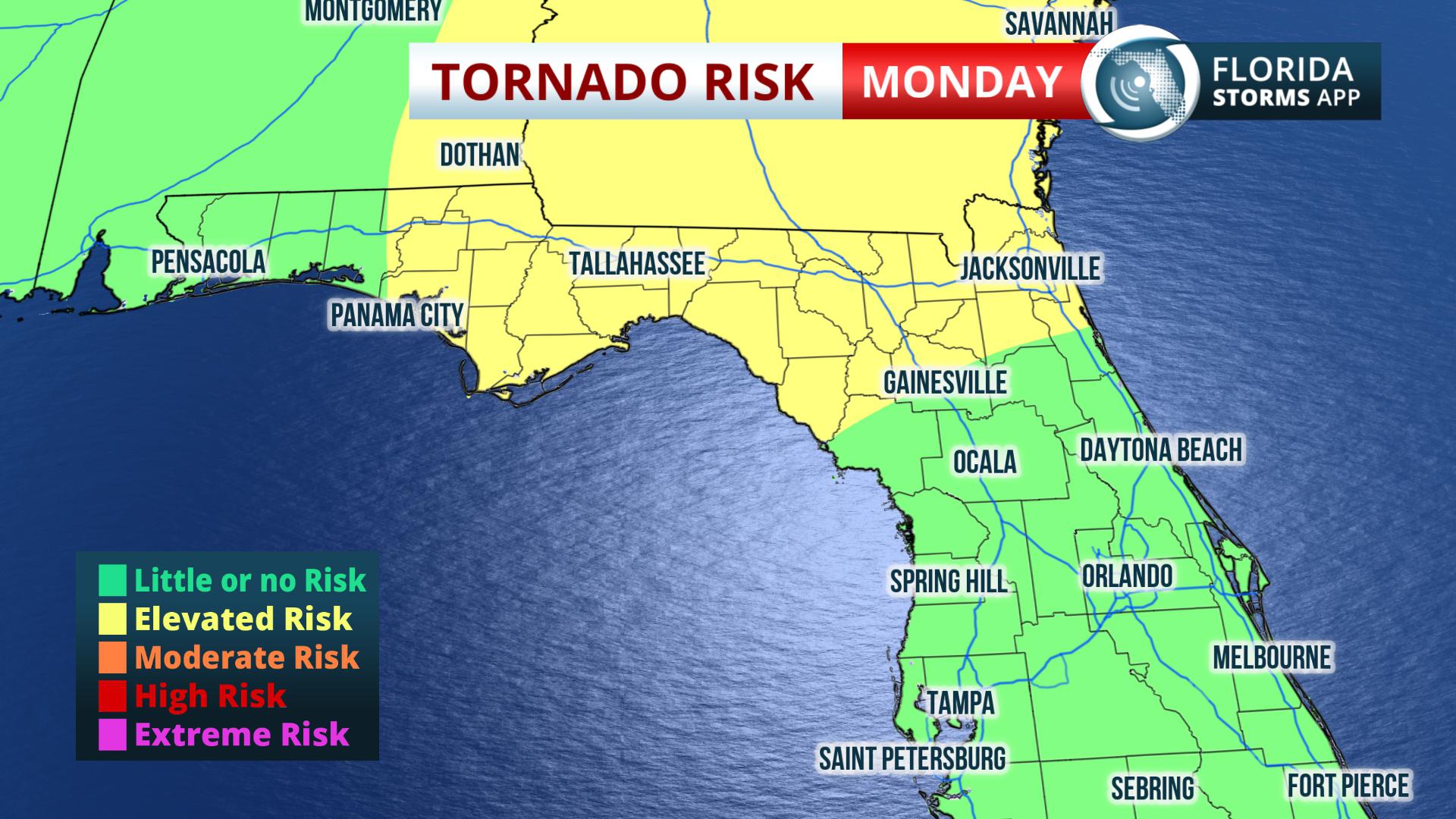 Elsewhere across Florida, the impacts from Alberto may not be as significant but still notable. The Storm Prediction Center has placed portions of north and northeast Florida under a marginal risk for severe thunderstorms and isolated tornadoes through Monday evening. While it was dry in many of these areas this morning, new bands of showers and thunderstorms are expected to develop in an increasingly unstable air mass from the Nature Coast to the First Coast Monday afternoon, with each individual cell capable of rotating and posing a damaging wind or tornado risk.

Further south, the rain just doesn't seem to want to stop. A Flood Watch continues for parts of east-central through Monday evening, and a new wave of heavy rain is likely to develop thanks to the seemingly relentless flow of tropical moisture. The heaviest rain with this next episode is expected to fall across Miami-Dade, Broward, and Palm Beach Counties Monday afternoon evening, where an additional 1 to 3 inches could further aggravate an ongoing flood risk in these areas.
Subtropical Storm Alberto is expected to accelerate north of Florida Tuesday, taking much of the hazardous weather concerns with it. However, rain chances will be higher than normal across the state all week, due primarily to high amounts of moisture leftover from the storm.
Frequent updates on Subtropical Storm Alberto, the tornado risk in north Florida, and the ongoing heavy rain episodes in South Florida are available on the Florida Storms Facebook and Twitter accounts, or via the mobile app Florida Storms.


